
Images


February 10, 2022 - Water in Lake Eyre
 Tweet
Tweet
Lake Eyre, Australia’s largest salt pan, sits in the dry outback about 647 km (402 miles) north of Adelaide in the state of South Australia. Also called Kati Thanda or Kati Thanda-Lake Eyre, the large lake sits 15 meter (49 ft) below sea level in one of the biggest internal drainage systems in the world. The Lake Eyre Basin stretches over southeastern Northern Territory, southwestern Queensland, northwestern New South Wales, and northeastern South Australia.
Normally the lake is nearly dry and crusted with salt, but when heavy rains fall anywhere across the basin, water often makes it way through rivers and channels to bring at least some moisture to Lake Eyre. Flooding strong enough to fill the lake id rare, but some seasonal filling is not uncommon, especially in the monsoon season, which runs from December through April in much of the Lake Eyre Basin.
Flooding rains struck parts of the Australia outback in late January 2022, followed by heavy storms in South Australia in early February, all adding up to record rainfalls to some areas. While the storms wreaked havoc over the past two weeks, washing out roads and flooding highways, the abundant water has begun to trickle-down to the Lake Eyre Basin.
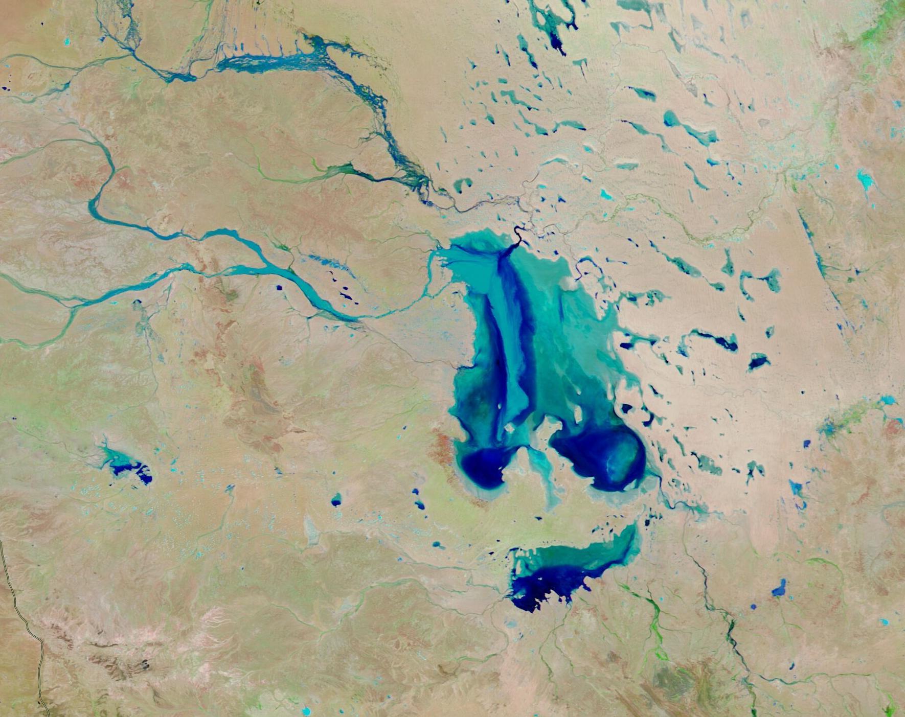
On February 5, 2022, the Moderate Resolution Imaging Spectroradiometer (MODIS) on board NASA’s Terra satellite acquired a false-color image of water filling Lake Eyre and the normally dry outback around the lake. The false-color images were composed from a combination of infrared and visible light (MODIS bands 7-2-1). Water appears dark and light blue; bare ground is brown; and vegetation is bright green. This band combination makes it easier to see where water is present.
While this one image is informative and dramatic, the NASA Worldview App makes it easy to view changes over time. To see the change in water level in Lake Eyre over just two days, a Worldview rollover comparison between two false-color Aqua MODIS images acquired just two days apart (this one from February 5 and one of the same area on February 3) can be viewed here.
According to the National Parks and Wildlife Service South Australia’s webpage, “each time the lake floods, the salt crust which forms much of the surface of the lake begins to dissolve until the salt level in the water reaches saturation point. When the lake starts to fill, the surface water is fairly fresh and drinkable because the heavier salty water is close to the lake bottom. From the air, water salinity variations can be seen as remarkable swirling current patterns.” Such swirling patterns are visible, especially in the southern portion of Lake Eyre North.
Image Facts
Satellite:
Terra
Date Acquired: 2/5/2021
Resolutions:
1km (212.2 KB), 500m (522.5 KB), 250m (286.1 KB)
Bands Used: 7,2,1
Image Credit:
MODIS Land Rapid Response Team, NASA GSFC
Lake Eyre, Australia’s largest salt pan, sits in the dry outback about 647 km (402 miles) north of Adelaide in the state of South Australia. Also called Kati Thanda or Kati Thanda-Lake Eyre, the large lake sits 15 meter (49 ft) below sea level in one of the biggest internal drainage systems in the world. The Lake Eyre Basin stretches over southeastern Northern Territory, southwestern Queensland, northwestern New South Wales, and northeastern South Australia.
Normally the lake is nearly dry and crusted with salt, but when heavy rains fall anywhere across the basin, water often makes it way through rivers and channels to bring at least some moisture to Lake Eyre. Flooding strong enough to fill the lake id rare, but some seasonal filling is not uncommon, especially in the monsoon season, which runs from December through April in much of the Lake Eyre Basin.
Flooding rains struck parts of the Australia outback in late January 2022, followed by heavy storms in South Australia in early February, all adding up to record rainfalls to some areas. While the storms wreaked havoc over the past two weeks, washing out roads and flooding highways, the abundant water has begun to trickle-down to the Lake Eyre Basin.
On February 5, 2022, the Moderate Resolution Imaging Spectroradiometer (MODIS) on board NASA’s Terra satellite acquired a false-color image of water filling Lake Eyre and the normally dry outback around the lake. The false-color images were composed from a combination of infrared and visible light (MODIS bands 7-2-1). Water appears dark and light blue; bare ground is brown; and vegetation is bright green. This band combination makes it easier to see where water is present.
While this one image is informative and dramatic, the NASA Worldview App makes it easy to view changes over time. To see the change in water level in Lake Eyre over just two days, a Worldview rollover comparison between two false-color Aqua MODIS images acquired just two days apart (this one from February 5 and one of the same area on February 3) can be viewed here.
According to the National Parks and Wildlife Service South Australia’s webpage, “each time the lake floods, the salt crust which forms much of the surface of the lake begins to dissolve until the salt level in the water reaches saturation point. When the lake starts to fill, the surface water is fairly fresh and drinkable because the heavier salty water is close to the lake bottom. From the air, water salinity variations can be seen as remarkable swirling current patterns.” Such swirling patterns are visible, especially in the southern portion of Lake Eyre North.
Image Facts
Satellite:
Terra
Date Acquired: 2/5/2021
Resolutions:
1km (212.2 KB), 500m (522.5 KB), 250m (286.1 KB)
Bands Used: 7,2,1
Image Credit:
MODIS Land Rapid Response Team, NASA GSFC
