
Images


April 1, 2025 - Burn Scar in South Korea


March 30, 2025
March 20, 2025
Tweet
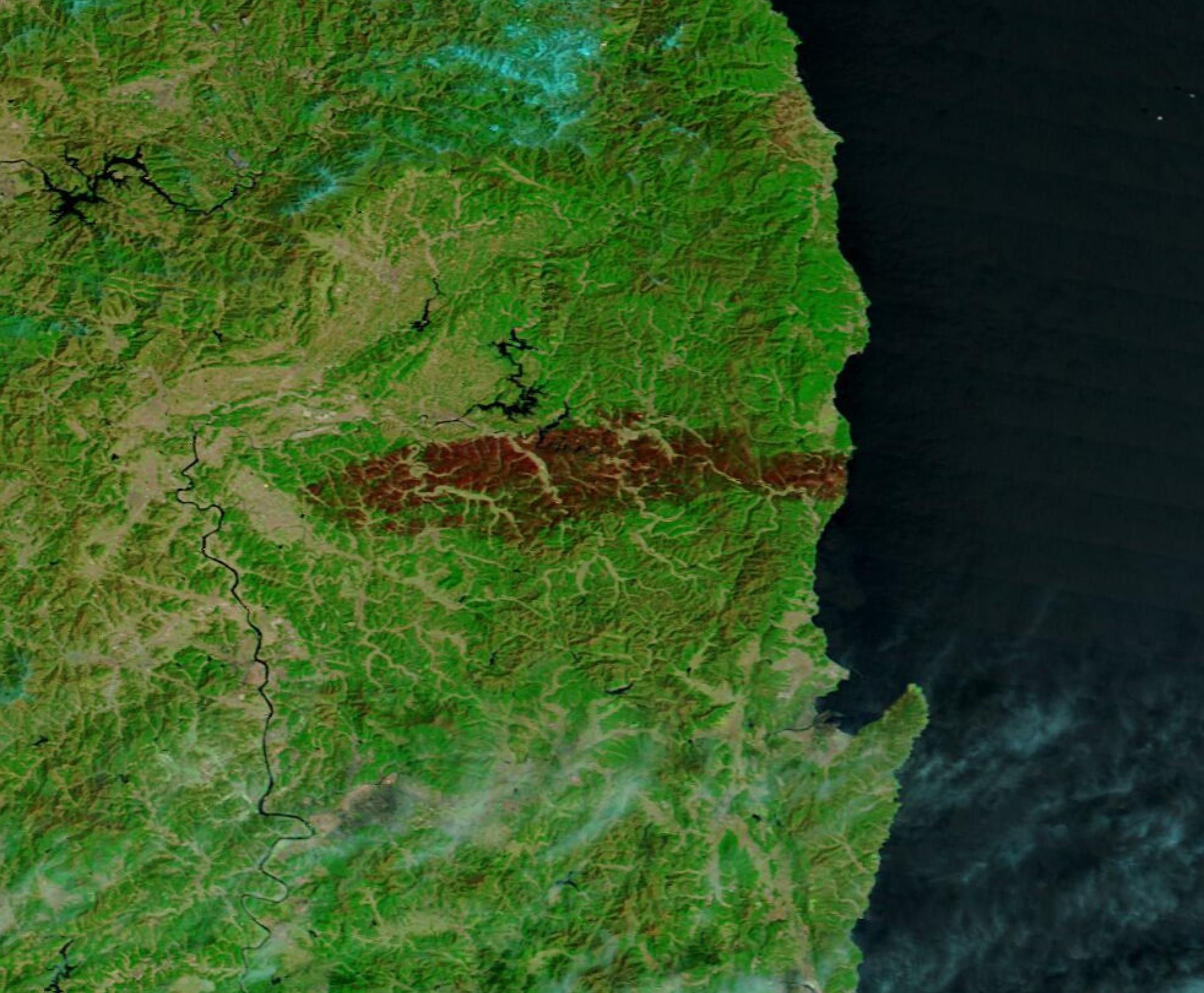
An outbreak of wildfires in South Korea left at least 28 people dead and more than 48,000 acres charred in late March 2025. The fires began on March 22 and, according to an article published on ReliefWeb, displaced about 37,000 people, and destroyed more than 320 buildings. Australia’s ABC News reported that a helicopter pilot died while fighting the fires when his aircraft went down in mountainous terrain. Several historic sites were said to have been destroyed, including the Gounsa temple complex in Uiseong. The temple complex dates back to the 7th century and is a UNESCO World Heritage site. The fires were declared contained on March 30.
The Moderate Resolution Imaging Spectroradiometer (MODIS) on NASA’s Terra satellite acquired two false-color images—one on March 30 and one on March 20— that reveal the massive size of the destructive fire in North and South Gyeongsang provinces.
In this type of image, vegetation appears bright green, water looks dark blue, open land is tan, and clouds are typically white although very high, cold clouds that contain ice may be tinted with light electric blue. Burn scars, which are the charred Earth that remains after a fire, may range in color from black, to tan, to brick red depending on a variety of factors. Recent burn scars are often brick red.
In the March 30 image, the vast swath of recent burn scar is quite obvious. Clicking on the date to reveal the March 20 image shows the widespread green of the provinces prior to the fire.
Image Facts
Satellite:
Terra
Date Acquired: 3/30/2025
Resolutions:
1km (93.6 KB), 500m (220.3 KB), 250m (372.3 KB)
Bands Used: 7,2,1
Image Credit:
MODIS Land Rapid Response Team, NASA GSFC
March 30, 2025 March 20, 2025
An outbreak of wildfires in South Korea left at least 28 people dead and more than 48,000 acres charred in late March 2025. The fires began on March 22 and, according to an article published on ReliefWeb, displaced about 37,000 people, and destroyed more than 320 buildings. Australia’s ABC News reported that a helicopter pilot died while fighting the fires when his aircraft went down in mountainous terrain. Several historic sites were said to have been destroyed, including the Gounsa temple complex in Uiseong. The temple complex dates back to the 7th century and is a UNESCO World Heritage site. The fires were declared contained on March 30.
The Moderate Resolution Imaging Spectroradiometer (MODIS) on NASA’s Terra satellite acquired two false-color images—one on March 30 and one on March 20— that reveal the massive size of the destructive fire in North and South Gyeongsang provinces.
In this type of image, vegetation appears bright green, water looks dark blue, open land is tan, and clouds are typically white although very high, cold clouds that contain ice may be tinted with light electric blue. Burn scars, which are the charred Earth that remains after a fire, may range in color from black, to tan, to brick red depending on a variety of factors. Recent burn scars are often brick red.
In the March 30 image, the vast swath of recent burn scar is quite obvious. Clicking on the date to reveal the March 20 image shows the widespread green of the provinces prior to the fire.
Image Facts
Satellite:
Terra
Date Acquired: 3/30/2025
Resolutions:
1km (93.6 KB), 500m (220.3 KB), 250m (372.3 KB)
Bands Used: 7,2,1
Image Credit:
MODIS Land Rapid Response Team, NASA GSFC
