
Images


February 15, 2022 - Burn Scars around Corrientes, Argentina
 Tweet
Tweet
Scorching summer temperatures, high winds, and dry vegetation have combined to turn parts of South America into a tinderbox. As of January 15, 2022, fires were burning in nine of Argentina’s 23 provinces. About 100 firefighters and support staff were fighting one exceptional blaze burning in the Nahuel Huapi National Park in Argentina’s Patagonia region.
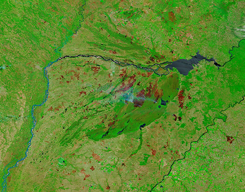
By February 14, another extreme set of blazes was ravaging forests in the Corrientes Province, located in northern Argentina near the Parana River. Those fires had consumed more than 500,000 hectares—roughly 6 percent of the land in the province. On that date, the Moderate Resolution Imaging Spectroradiometer (MODIS) on board NASA’s Terra satellite acquired a false-color image of the fire-raved region of Corrientes.
This type of false-color image uses infrared and visible light (MODIS bands 7,2,1), which helps highlight vegetation and burned areas. Vegetation appears bright green, open land appears brown or tan, and water appears blue, with shallow water lighter than the inky-blue of deeper water. Smoke rising from the fires appears bright blue. Burn scars—areas that have been burnt by fire—may vary in color, typically appearing brick red when the land has been recently burned and appearing lighter red or tan in older burnt areas as vegetative growth begins to fill back in. In extreme fires, the burn scar may appear black. This image shows a many, many fresh burn scars in the vegetation to the east of the Parana River.
While this one image gives an accurate and impressive look at the damage the fires have caused, more useful information can often be gained by comparing more than one image taken at different times. Thanks to the NASA Worldview App, such comparisons are easy. To see a comparison between a Terra MODIS image taken on January 13,prior to the start of the fires, and the image acquired on February 14, click here.
Image Facts
Satellite:
Terra
Date Acquired: 2/14/2022
Resolutions:
1km (334.1 KB), 500m (849.6 KB), 250m (483.3 KB)
Bands Used: 7,2,1
Image Credit:
MODIS Land Rapid Response Team, NASA GSFC
Scorching summer temperatures, high winds, and dry vegetation have combined to turn parts of South America into a tinderbox. As of January 15, 2022, fires were burning in nine of Argentina’s 23 provinces. About 100 firefighters and support staff were fighting one exceptional blaze burning in the Nahuel Huapi National Park in Argentina’s Patagonia region.
By February 14, another extreme set of blazes was ravaging forests in the Corrientes Province, located in northern Argentina near the Parana River. Those fires had consumed more than 500,000 hectares—roughly 6 percent of the land in the province. On that date, the Moderate Resolution Imaging Spectroradiometer (MODIS) on board NASA’s Terra satellite acquired a false-color image of the fire-raved region of Corrientes.
This type of false-color image uses infrared and visible light (MODIS bands 7,2,1), which helps highlight vegetation and burned areas. Vegetation appears bright green, open land appears brown or tan, and water appears blue, with shallow water lighter than the inky-blue of deeper water. Smoke rising from the fires appears bright blue. Burn scars—areas that have been burnt by fire—may vary in color, typically appearing brick red when the land has been recently burned and appearing lighter red or tan in older burnt areas as vegetative growth begins to fill back in. In extreme fires, the burn scar may appear black. This image shows a many, many fresh burn scars in the vegetation to the east of the Parana River.
While this one image gives an accurate and impressive look at the damage the fires have caused, more useful information can often be gained by comparing more than one image taken at different times. Thanks to the NASA Worldview App, such comparisons are easy. To see a comparison between a Terra MODIS image taken on January 13,prior to the start of the fires, and the image acquired on February 14, click here.
Image Facts
Satellite:
Terra
Date Acquired: 2/14/2022
Resolutions:
1km (334.1 KB), 500m (849.6 KB), 250m (483.3 KB)
Bands Used: 7,2,1
Image Credit:
MODIS Land Rapid Response Team, NASA GSFC
