
Images


April 25, 2022 - Uyuni Salt Pan Drying Out
 Tweet
Tweet
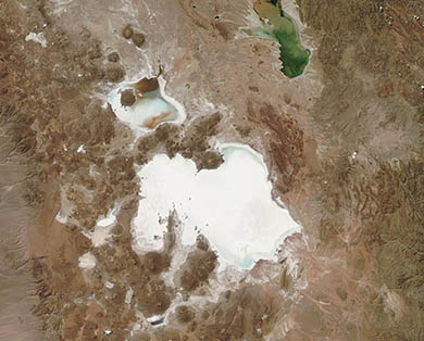
Seated on the high Altiplano of Bolivia, the Salar de Uyuni shimmers bright white in satellite imagery, thanks to the thick, salt-rich mineral crust that spans roughly 4,000 square miles (10,000 square kilometers). The Altiplano plateau was formed during the uplift of the Andes Mountains, which surround the region. The plateau harbors fresh and saltwater lakes as well as several salars (salt flats) but the largest salar in all of Bolivia—and the largest on Earth—is the Salar de Uyuni.
Most of the year, this enormous salt flat wears a thick, nearly unbroken, salty crust. During the rainy season, however, water often collects in the Salar de Uyuni, melting some of the salt and expanding the size of the salt flat. The expansion is always temporary, as the hot dry season drives rapid evaporation that once again shrinks the Salar de Uyuni as well as the other salars of the Altiplano.
Abundant rainfall around the Altiplano in the 2021-2022 rainy season filled the Salar de Uyuni beyond the brim.
According to an article published by NASA’s Earth Observatory on February 19, 2022, hydrologist Jorge Molina Carpio of the Universidad Mayor de San Andrés explained that the extent of the filling of Salar de Uyuni this year is above normal. The rainy season started earlier than previous years (it began in November 2021), and rainfall was well above average over the southern Altiplano. He stated, “This was probably related to the onset of a significant La Niña event. Strong La Niñas during the rainy season are related to positive rainfall anomalies in the southern Altiplano.” Despite the abundance of water in the Salar de Uyuni by February 2022, the onset of the dry season has seen rapid shrinking.
The Moderate Resolution Imaging Spectroradiometer (MODIS) on board NASA’s Aqua satellite acquired a true-color image of the Salar de Uyuni on April 21, 2022. Most of the salt flat appears bright white, indicating dry conditions. A few gray and blue-gray areas mark remaining moisture both in the Salar de Uyuni as well as the smaller Salar de Coipas. This is in marked contrast to the conditions seen on February 11, 2022, when the salt crust of the Salar de Coipas was almost entirely dissolved as that salt flat filled with fresh rainwater. The salty crust of the Salar de Uyuni was still present, especially in the western section, but it was also filled with water, coloring it with swirls of blue, gray, and brown.
Although a single image can give an informative view of an area at a specific time and date, comparing two images acquired on different dates gives a much better understanding of change over time. Thanks to the NASA Worldview App, it is easy to view a roll-over comparison between the Aqua MODIS image acquired on April 21 and the one acquired on February 11. To see this comparison, simply click here.
Image Facts
Satellite:
Aqua
Date Acquired: 4/21/2022
Resolutions:
1km (51.5 KB), 500m (123.7 KB), 250m (259.8 KB)
Bands Used: 1,4,3
Image Credit:
MODIS Land Rapid Response Team, NASA GSFC
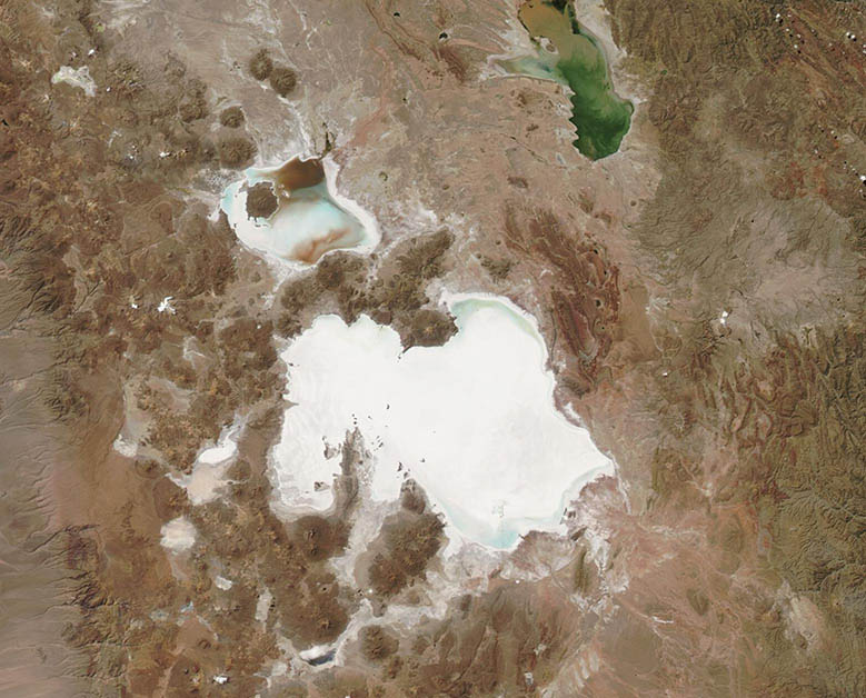
Seated on the high Altiplano of Bolivia, the Salar de Uyuni shimmers bright white in satellite imagery, thanks to the thick, salt-rich mineral crust that spans roughly 4,000 square miles (10,000 square kilometers). The Altiplano plateau was formed during the uplift of the Andes Mountains, which surround the region. The plateau harbors fresh and saltwater lakes as well as several salars (salt flats) but the largest salar in all of Bolivia—and the largest on Earth—is the Salar de Uyuni.
Most of the year, this enormous salt flat wears a thick, nearly unbroken, salty crust. During the rainy season, however, water often collects in the Salar de Uyuni, melting some of the salt and expanding the size of the salt flat. The expansion is always temporary, as the hot dry season drives rapid evaporation that once again shrinks the Salar de Uyuni as well as the other salars of the Altiplano.
Abundant rainfall around the Altiplano in the 2021-2022 rainy season filled the Salar de Uyuni beyond the brim. According to an article published by NASA’s Earth Observatory on February 19, 2022, hydrologist Jorge Molina Carpio of the Universidad Mayor de San Andrés explained that the extent of the filling of Salar de Uyuni this year is above normal. The rainy season started earlier than previous years (it began in November 2021), and rainfall was well above average over the southern Altiplano. He stated, “This was probably related to the onset of a significant La Niña event. Strong La Niñas during the rainy season are related to positive rainfall anomalies in the southern Altiplano.” Despite the abundance of water in the Salar de Uyuni by February 2022, the onset of the dry season has seen rapid shrinking.
The Moderate Resolution Imaging Spectroradiometer (MODIS) on board NASA’s Aqua satellite acquired a true-color image of the Salar de Uyuni on April 21, 2022. Most of the salt flat appears bright white, indicating dry conditions. A few gray and blue-gray areas mark remaining moisture both in the Salar de Uyuni as well as the smaller Salar de Coipas. This is in marked contrast to the conditions seen on February 11, 2022, when the salt crust of the Salar de Coipas was almost entirely dissolved as that salt flat filled with fresh rainwater. The salty crust of the Salar de Uyuni was still present, especially in the western section, but it was also filled with water, coloring it with swirls of blue, gray, and brown.
Although a single image can give an informative view of an area at a specific time and date, comparing two images acquired on different dates gives a much better understanding of change over time. Thanks to the NASA Worldview App, it is easy to view a roll-over comparison between the Aqua MODIS image acquired on April 21 and the one acquired on February 11. To see this comparison, simply click here.
Image Facts
Satellite:
Aqua
Date Acquired: 4/21/2022
Resolutions:
1km (51.5 KB), 500m (123.7 KB), 250m (259.8 KB)
Bands Used: 1,4,3
Image Credit:
MODIS Land Rapid Response Team, NASA GSFC
