
Images


April 27, 2022 - Wildfires in New Mexico
 Tweet
Tweet
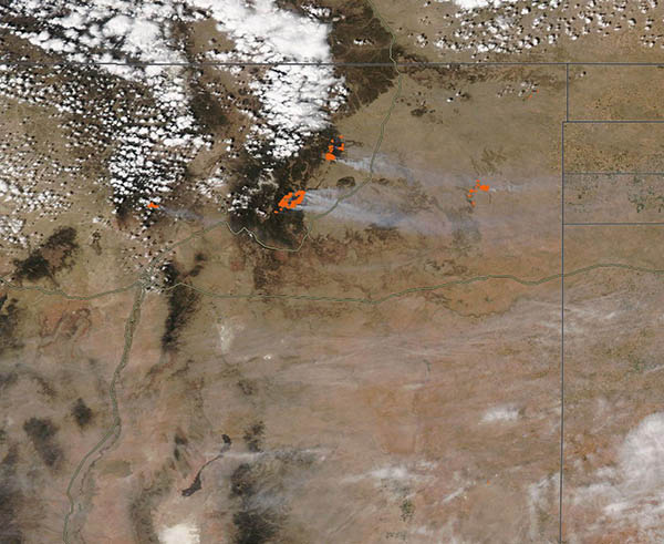
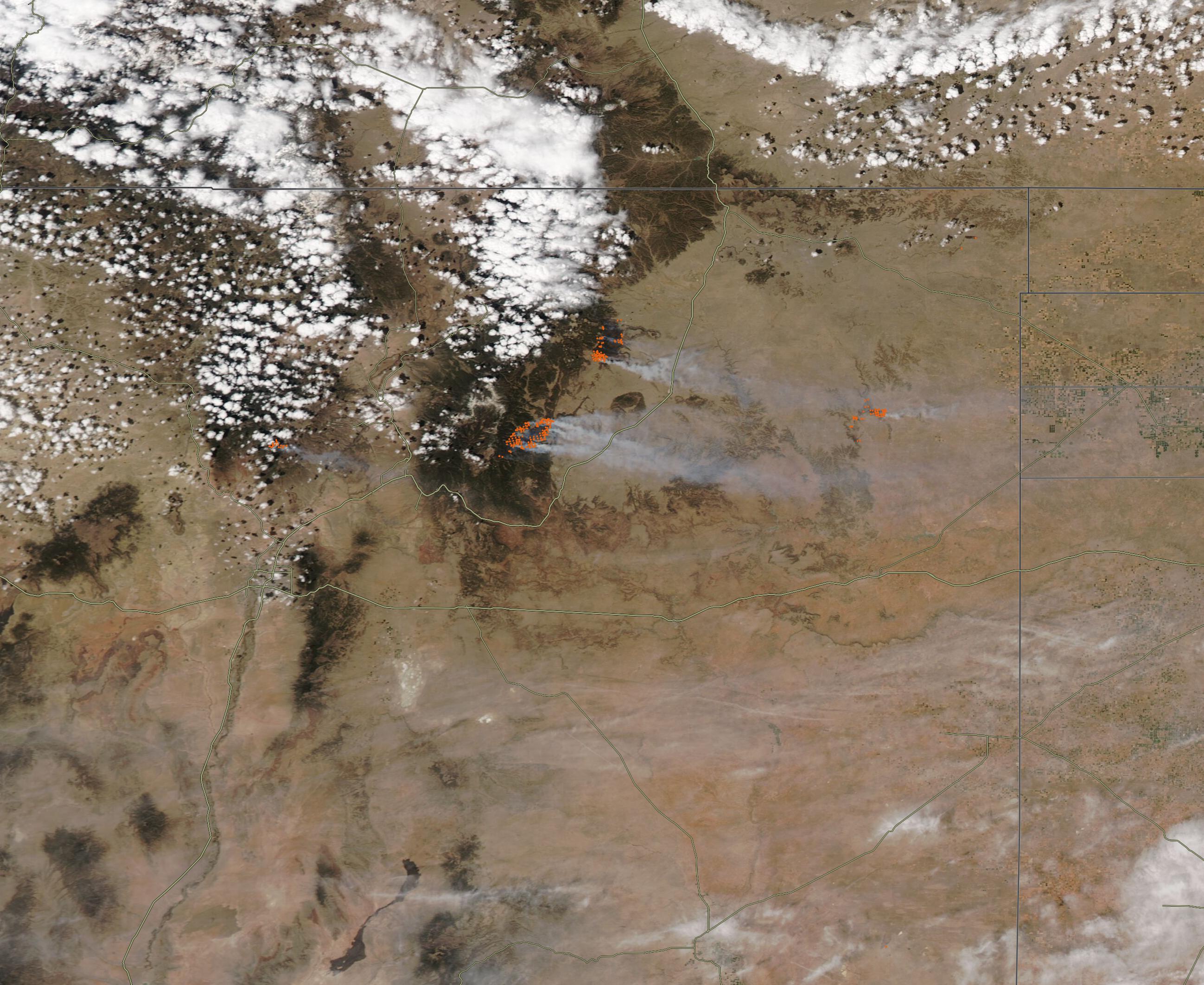
The 2022 New Mexico fire season roared to an early and destructive start, thanks to extremely low humidity, an exceptionally dry landscape, and strong, gusty winds. As of April 19, nearly 99 percent of the state was dealing with some level of drought, according to the U.S. Drought Monitor, with 63 percent rated at extreme to exceptional levels of dryness. Amid those conditions, the Inciweb Incident Information System reported 11 fires burning across New Mexico on April 26.
The Moderate Resolution Imaging Spectroradiometer (MODIS) on board NASA’s Aqua satellite acquired a true-color image of the area near the city of Santa Fe on April 26. Each red “hot spot” marks an area where the thermal bands on the instrument detected high temperatures. When combined with typical smoke, such hot spots are diagnostic for actively burning fire.
This image captures four individually-named fires, and each fire contains numerous hot spots. This is a typical pattern seen in large fires, especially when fires are spreading from the center outward. Areas already burned don’t necessarily show as hot spots, but the leading edges will. As a fire grows, it expands from the center, creating several actively-burning areas while other areas within the fire radius may not yet have burned. This image also shows heavy smoke rising from most of the fires, as well as a long band of smoke stretching across New Mexico from west to east. This lower band of smoke, which is south of the fires in this image, likely originates from fires in southern and southwestern New Mexico and in Arizona.
To the west of Santa Fe, the Cerro Pelado fire burns in timber and brush in the Santa Fe National Forest. First reported on April 22, it has burned 5,485 acres. According to Inciweb, 281 personnel are working this fire, which is 0 percent contained. Estimated containment date is May 5.
To the east of Santa Fe, a cluster of red hot spots mark both the Hermit’s Peak fire and the Calf Canyon fire. The Calf Canyon fire began on April 19, and the cause is under investigation. The Hermits Peak ignited on April 6, and initially was a prescribed burn in part of the Sant Fe National Forest, but erratic, gusty winds blew it out of control. Strong winds on April 22-23 pushed the fire through steep terrain and caused a merger with the Calf Canyon fire, creating a fire complex with more than 180 miles of perimeter. Residents in parts of San Miguel, Mora, and Colfax counties were told to evacuate their homes. As of April 26, the complex fire had consumed 60,173 acres and was 12 percent contained. With 817 personnel currently working the blaze, the estimated containment date is July 31.
To the northeast, the Cooks Peak fire burned through 54,021 acres and was 18 percent contained as of the morning of April 26. It began on April 17, and the cause is under investigation.
Further east, the Mitchell Fire is burning in pinon-juniper and grassland. It began on April 22 off of New Mexico Highway 39 near David Hill and has burned 25,000 acres. As of April 26, the fire was reported as 60 percent contained.
According to the National Interagency Fire Center on April 25, fourteen large, active fires were burning across 244,000 acres in eleven states. Since the start of 2022, at least 20,262 wildfires have burned 865,290 acres in the United States, well above the 10–year average through April.
In research published in November 2021, scientists found that burned acreage from wildfires in the western United States doubled between the period of 1984–2000 and 2001–2018. They attributed the increase in fire to a significant change in the vapor pressure deficit, a measurement of how hot and dry the atmosphere can get. Global warming, they noted, has been intensifying vapor pressure deficits, making vegetation more susceptible to burning and the atmosphere more conducive to sustaining fire. Other researchers also found that wildfires have been spreading to higher elevations in the U.S. West in recent decades.
Image Facts
Satellite:
Aqua
Date Acquired: 4/23/2022
Resolutions:
1km (102.3 KB), 500m (214.1 KB), 250m (706.9 KB)
Bands Used: 1,4,3
Image Credit:
MODIS Land Rapid Response Team, NASA GSFC
