
Images


May 4, 2022 - Deforestation around Xingu National Park in Brazil
 Tweet
Tweet
The state of Mato Grosso sits deep in the Amazon interior of Brazil. Once covered with verdant green rainforest and isolated, the incursion of railroads, highways, and airplanes eventually connected Mato Grosso to the outside world. By the early twenty-first century, widespread change was evident across all of the state, as well as much of South America’s rainforest. Widespread deforestation had become rampant.
As early as the 1960’s the Brazilian government had the foresight to create some protected areas in the rainforest. A notable achievement was the creation of Xingu National Park and Indigenous Peoples Preserve, an expanse of about 8,530 square miles (22,090 square km) in the northeastern part of Mato Grosso. With the land centered on the Xingu River, the park was set aside to preserve biodiversity as well as to allow a traditional life for the four major aboriginal language families in Brazil, the Tupi, Arawak, Carib, and Ge. The ecology of the Xingu reflects a transitional zone between the vegetation of the cerrado (tropical savannah) and the Amazonian rainforest. It is one of the last remaining stand of rainforest in northern Mato Grosso to this day.
The 1990s and 2000s saw what has been called “open season on the rainforest”, with ranchers, soy farmers, land speculators, loggers and miners able to clear just about any land that they wanted. During that time, Brazilian rainforest was sometimes losing more than 20,000 square kilometers (8,000 square miles) per year, an area nearly the size of New Jersey. As the ransacking of the Amazon became widely known—thanks at least in part due to satellite imagery of the demise of the “lungs of the world” becoming widely shared with the public—public pressure started to slow the tide of deforestation. In 2004, the Brazilian government adopted an aggressive policy called the Action Plan for the Prevention and Control of Deforestation in the Legal Amazon (PPCDAm). The government created a large network of national and state parks, established protected territories for indigenous groups, strengthened environmental enforcement agencies, made it more difficult to export goods produced on illegally deforested land, and strengthened satellite monitoring systems.
Thanks to the laws, enforcement efforts, public pressure, education, and rigorous monitoring for deforestation in near-real-time by several satellite systems, by 2012, forest clearing was still occurring, but at a much lower rate. Clearing was reported to be down nearly 80 percent, or roughly 5,000 square kilometers (1,900 square miles) per year. The turnaround was heralded as one of the world’s most dramatic environmental success stories. Soon, the type of deforestation also changed. Because large clear-cuts were easily seen by satellite (and then stopped by law enforcement), most of those encroaching on the forest started to clear small patches instead of vast swaths and often worked during the rainy season, when cloud cover obscured satellite views.
A major policy change in Brazil occurred in 2019, when the current President, Jair Bolsonaro, took office. Since that time, environmental restrictions have been softened or ignored, leading to increasingly rapid deforestation across all of Brazil. A report published by Brazil’s National Institute for Space Research (INPE) in November 2021 estimated that 13,235 square kilometers (8,224 square miles) of forest was lost between August 2020 and July 2021. That was a 22% increase from the previous year and the largest area lost to deforestation in the Brazilian Amazon since 2006, when a total area of 14,286 square kilometers was cleared. In January 2022, the INPE data showed that 430 square km (166 square miles) of the Amazon were cleared in that month alone—an all-time monthly high.
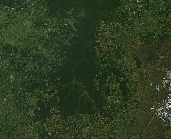
On May 2, 2022, the Moderate Resolution Imaging Spectroradiometer (MODIS) acquired a true-color image of heavy deforestation around the Xingu National Park and Indigenous Peoples Preserve. The remaining forest within the Park appears dark green while areas stripped of forest, which encircle the Park, appear light green. While the bulk of the Park remains mostly intact, many reports of incursions of industry and agriculture into park boundaries exist and seem to be increasing.
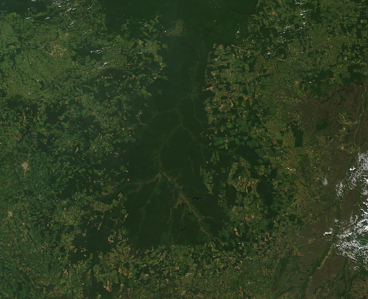
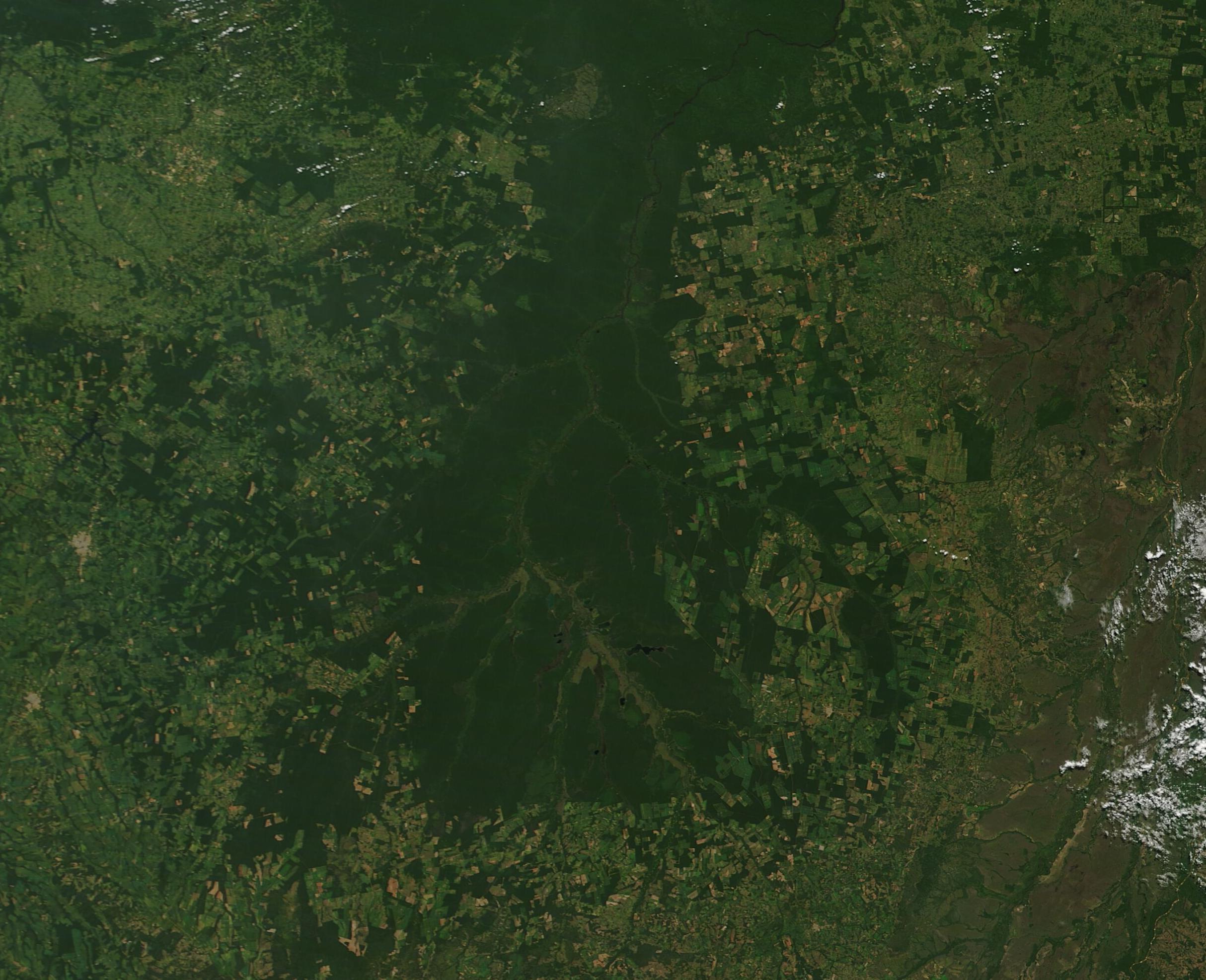
To better illustrate the landcover change, the below roll-over comparison, which was created using the NASA Worldview App, allows easy evaluation of the same area over time. In this case, the image acquired on May 2, 2022 (above) can be compared to an earlier image acquired on April 28, 2003. In the earlier image, the deep green forest stretches covers much more of the area. By 2022, severe deforestation has stripped much of the region of trees, especially in the land adjacent to the southwestern section of Xingu National Park.
To interact with the roll-over comparision, click anywhere on the image below. The older (2003) image will be on the left side of the screen and the newest one (2022) will be on the right. To go to a larger view of the region via the NASA Worldview App, click on the icon in the upper right of the lower image.
Image Facts
Satellite:
Terra
Date Acquired: 5/2/2022
Resolutions:
1km (337.3 KB), 500m (875.6 KB), 250m (514.2 KB)
Bands Used: 1,4,3
Image Credit:
MODIS Land Rapid Response Team, NASA GSFC
The state of Mato Grosso sits deep in the Amazon interior of Brazil. Once covered with verdant green rainforest and isolated, the incursion of railroads, highways, and airplanes eventually connected Mato Grosso to the outside world. By the early twenty-first century, widespread change was evident across all of the state, as well as much of South America’s rainforest. Widespread deforestation had become rampant.
As early as the 1960’s the Brazilian government had the foresight to create some protected areas in the rainforest. A notable achievement was the creation of Xingu National Park and Indigenous Peoples Preserve, an expanse of about 8,530 square miles (22,090 square km) in the northeastern part of Mato Grosso. With the land centered on the Xingu River, the park was set aside to preserve biodiversity as well as to allow a traditional life for the four major aboriginal language families in Brazil, the Tupi, Arawak, Carib, and Ge. The ecology of the Xingu reflects a transitional zone between the vegetation of the cerrado (tropical savannah) and the Amazonian rainforest. It is one of the last remaining stand of rainforest in northern Mato Grosso to this day.
The 1990s and 2000s saw what has been called “open season on the rainforest”, with ranchers, soy farmers, land speculators, loggers and miners able to clear just about any land that they wanted. During that time, Brazilian rainforest was sometimes losing more than 20,000 square kilometers (8,000 square miles) per year, an area nearly the size of New Jersey. As the ransacking of the Amazon became widely known—thanks at least in part due to satellite imagery of the demise of the “lungs of the world” becoming widely shared with the public—public pressure started to slow the tide of deforestation. In 2004, the Brazilian government adopted an aggressive policy called the Action Plan for the Prevention and Control of Deforestation in the Legal Amazon (PPCDAm). The government created a large network of national and state parks, established protected territories for indigenous groups, strengthened environmental enforcement agencies, made it more difficult to export goods produced on illegally deforested land, and strengthened satellite monitoring systems.
Thanks to the laws, enforcement efforts, public pressure, education, and rigorous monitoring for deforestation in near-real-time by several satellite systems, by 2012, forest clearing was still occurring, but at a much lower rate. Clearing was reported to be down nearly 80 percent, or roughly 5,000 square kilometers (1,900 square miles) per year. The turnaround was heralded as one of the world’s most dramatic environmental success stories. Soon, the type of deforestation also changed. Because large clear-cuts were easily seen by satellite (and then stopped by law enforcement), most of those encroaching on the forest started to clear small patches instead of vast swaths and often worked during the rainy season, when cloud cover obscured satellite views.
A major policy change in Brazil occurred in 2019, when the current President, Jair Bolsonaro, took office. Since that time, environmental restrictions have been softened or ignored, leading to increasingly rapid deforestation across all of Brazil. A report published by Brazil’s National Institute for Space Research (INPE) in November 2021 estimated that 13,235 square kilometers (8,224 square miles) of forest was lost between August 2020 and July 2021. That was a 22% increase from the previous year and the largest area lost to deforestation in the Brazilian Amazon since 2006, when a total area of 14,286 square kilometers was cleared. In January 2022, the INPE data showed that 430 square km (166 square miles) of the Amazon were cleared in that month alone—an all-time monthly high.
On May 2, 2022, the Moderate Resolution Imaging Spectroradiometer (MODIS) acquired a true-color image of heavy deforestation around the Xingu National Park and Indigenous Peoples Preserve. The remaining forest within the Park appears dark green while areas stripped of forest, which encircle the Park, appear light green. While the bulk of the Park remains mostly intact, many reports of incursions of industry and agriculture into park boundaries exist and seem to be increasing.
To better illustrate the landcover change, the below roll-over comparison, which was created using the NASA Worldview App, allows easy evaluation of the same area over time. In this case, the image acquired on May 2, 2022 (above) can be compared to an earlier image acquired on April 28, 2003. In the earlier image, the deep green forest stretches covers much more of the area. By 2022, severe deforestation has stripped much of the region of trees, especially in the land adjacent to the southwestern section of Xingu National Park.
To interact with the roll-over comparision, click anywhere on the image below. The older (2003) image will be on the left side of the screen and the newest one (2022) will be on the right. To go to a larger view of the region via the NASA Worldview App, click on the icon in the upper right of the lower image.
Image Facts
Satellite:
Terra
Date Acquired: 5/2/2022
Resolutions:
1km (337.3 KB), 500m (875.6 KB), 250m (514.2 KB)
Bands Used: 1,4,3
Image Credit:
MODIS Land Rapid Response Team, NASA GSFC
