
Images


May 23, 2022 - Burn Scar in New Mexico
 Tweet
Tweet
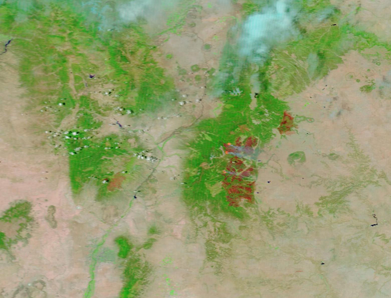
A fierce fire season has been scorching parts of the Southwestern United States since April 2022 and leaving behind large scars on the landscape. On May 19, 2022, the Moderate Resolution Imaging Spectroradiometer on board NASA’s Terra satellite acquired a false-color image of burn scars left by three fires in northern New Mexico, including the largest fire ever recorded in that state.
This type of false-color image uses visible and near-infrared light (bands 7,2,1) to highlight areas where fire has destroyed vegetation and charred land. Burn scars can appear black, brown, or brick red in this type of image while vegetation appears bright green, open land looks tan tan, deep water is colored deep blue, and clouds may appear either white or tinted with electric blue. The color variation in burn scars depends on type of vegetation burned, the completeness of the burn, the amount of residue remaining after the burn, and the age of the burn. Light orange indicates actively burning areas.
The largest burn scar marks the Calf Canyon/Hermits Peak fire, which has become the largest fire in New Mexico’s history. It began as two separate fires. The Calf Canyon fire ignited on April 19, and the cause is under investigation. On April 6, the Hermits Peak fire began as a prescribed burn in part of the Sant Fe National Forest, but erratic, gusty winds blew it out of control. Strong winds on April 22-23 pushed the fire through steep terrain and caused a merger with the Calf Canyon fire, creating a fire complex. On May 2, the fire complex had scorched 120,653 acres. Five days later, with reports of the flames spreading as fast as 50 miles per hour, the Calf Canyon/Hermits Peak fire become the second-largest fire in New Mexico’s history, stretching over 170,665 acres. Soon the rapidly-spreading fire surpassed the Whitewater-Baldy complex Fire—a massive inferno that destroyed 297,845 acres in the Gila National Forest in 2012—to capture the record as the largest fire. As of May 22, the Calf Canyon/Hermits Peak fire has burned 310,253 acres and was only 40 percent contained. This is more than double the size of Albuquerque, New Mexico’s largest city. Over the last two days the temperatures have decreased and humidity increased, giving some slight assistance to firefighting on this blaze, but it is still extremely active.
The other burn scars are the Cerro Pelado Fire, to the west of Calf Canyon/Hermits Peak fire and the Cooks Peak Fire, to the northeast. The Cerro Pelado Fire was first reported on April 22 in timber and brush in the Santa Fe National Forest. On May 22, this fire had burned 45,605 acres and the 594 personnel working the fire had helped bring it to 85 percent containment. The Cooks Peak Fire ignited on April 17 from human activity and the cause is under investigation. It burned 59,379 acres and was fully contained on May 13.
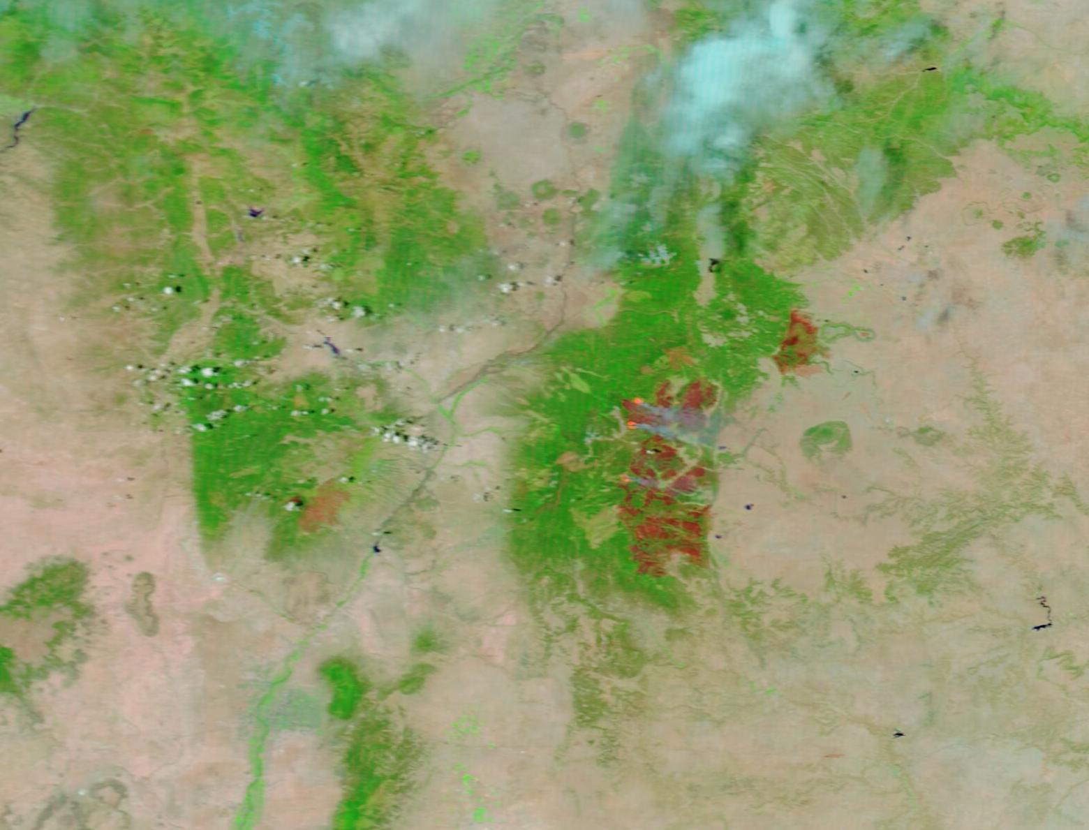
While this single image shows dramatic burn scars from truly massive fires, to understand the expansion over time it is helpful to compare two images acquired on two different days. Thanks to the NASA Worldview App, a roll-over comparison of MODIS false-color images of northern New Mexico acquired on May 3, 2022, and this one, acquired on May 19 can be found here.
NASA's Earth Observing System Data and Information System (EOSDIS) Worldview application provides the capability to interactively browse over 700 global, full-resolution satellite imagery layers and then download the underlying data. Many of the available imagery layers are updated within three hours of observation, essentially showing the entire Earth as it looks "right now".
Image Facts
Satellite:
Terra
Date Acquired: 5/19/2022
Resolutions:
1km (141.4 KB), 500m (310.5 KB), 250m (151.6 KB)
Bands Used: 7,2,1
Image Credit:
MODIS Land Rapid Response Team, NASA GSFC
A fierce fire season has been scorching parts of the Southwestern United States since April 2022 and leaving behind large scars on the landscape. On May 19, 2022, the Moderate Resolution Imaging Spectroradiometer on board NASA’s Terra satellite acquired a false-color image of burn scars left by three fires in northern New Mexico, including the largest fire ever recorded in that state.
This type of false-color image uses visible and near-infrared light (bands 7,2,1) to highlight areas where fire has destroyed vegetation and charred land. Burn scars can appear black, brown, or brick red in this type of image while vegetation appears bright green, open land looks tan tan, deep water is colored deep blue, and clouds may appear either white or tinted with electric blue. The color variation in burn scars depends on type of vegetation burned, the completeness of the burn, the amount of residue remaining after the burn, and the age of the burn. Light orange indicates actively burning areas.
The largest burn scar marks the Calf Canyon/Hermits Peak fire, which has become the largest fire in New Mexico’s history. It began as two separate fires. The Calf Canyon fire ignited on April 19, and the cause is under investigation. On April 6, the Hermits Peak fire began as a prescribed burn in part of the Sant Fe National Forest, but erratic, gusty winds blew it out of control. Strong winds on April 22-23 pushed the fire through steep terrain and caused a merger with the Calf Canyon fire, creating a fire complex. On May 2, the fire complex had scorched 120,653 acres. Five days later, with reports of the flames spreading as fast as 50 miles per hour, the Calf Canyon/Hermits Peak fire become the second-largest fire in New Mexico’s history, stretching over 170,665 acres. Soon the rapidly-spreading fire surpassed the Whitewater-Baldy complex Fire—a massive inferno that destroyed 297,845 acres in the Gila National Forest in 2012—to capture the record as the largest fire. As of May 22, the Calf Canyon/Hermits Peak fire has burned 310,253 acres and was only 40 percent contained. This is more than double the size of Albuquerque, New Mexico’s largest city. Over the last two days the temperatures have decreased and humidity increased, giving some slight assistance to firefighting on this blaze, but it is still extremely active.
The other burn scars are the Cerro Pelado Fire, to the west of Calf Canyon/Hermits Peak fire and the Cooks Peak Fire, to the northeast. The Cerro Pelado Fire was first reported on April 22 in timber and brush in the Santa Fe National Forest. On May 22, this fire had burned 45,605 acres and the 594 personnel working the fire had helped bring it to 85 percent containment. The Cooks Peak Fire ignited on April 17 from human activity and the cause is under investigation. It burned 59,379 acres and was fully contained on May 13.
While this single image shows dramatic burn scars from truly massive fires, to understand the expansion over time it is helpful to compare two images acquired on two different days. Thanks to the NASA Worldview App, a roll-over comparison of MODIS false-color images of northern New Mexico acquired on May 3, 2022, and this one, acquired on May 19 can be found here.
NASA's Earth Observing System Data and Information System (EOSDIS) Worldview application provides the capability to interactively browse over 700 global, full-resolution satellite imagery layers and then download the underlying data. Many of the available imagery layers are updated within three hours of observation, essentially showing the entire Earth as it looks "right now".
Image Facts
Satellite:
Terra
Date Acquired: 5/19/2022
Resolutions:
1km (141.4 KB), 500m (310.5 KB), 250m (151.6 KB)
Bands Used: 7,2,1
Image Credit:
MODIS Land Rapid Response Team, NASA GSFC
