
Images


June 9, 2022 - Saharan Dust over the Caribbean and South America
 Tweet
Tweet
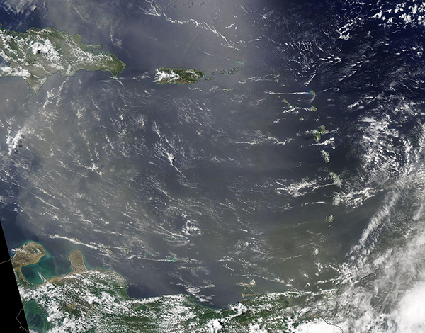
On June 1, 2022, strong winds blew a thick layer of dust from the Sahara Desert, pushing it westward over the Atlantic Ocean. The dense dust plume continued to grow in size and length, and by June 6, the leading edge of the massive river of dust reached South America. The dust plume stretched more than 3,500 miles (5,630 km) and covered more than 2.2 million square miles (5.7 million square km).
On June 7, 2022, the Moderate Resolution Imaging Spectroradiometer (MODIS) on board NASA’s Aqua satellite acquired a true-color image of Saharan Dust over the Caribbean and South America. Dust hovers over northern Venezuela as well as many of the Caribbean Islands, including Aruba and Curacao near the coast of South America and Puerto Rico and the Dominican Republic, seen in the north of the image. The Saharan dust is expected to reach the Gulf of Mexico over the next few days and is expected to color skies over Texas and possibly other southern U.S. states by June 12.
The Sahara Desert is by far Earth’s largest source of airborne dust, and the storms can arise at any time of year. In winter and spring storms, Saharan dust often ends up fertilizing the nutrient-poor soils of the Amazon rainforest. Dust storms in the summer tend to loft material higher into the atmosphere, allowing plumes to travel thousands of kilometers on high-level winds. Those summer seasonal wind patterns can carry the dust from Africa to the Caribbean and the Gulf of Mexico. Plumes of dust recently reached Florida, Texas, and other southern U.S. states in mid-May 2022.
Image Facts
Satellite:
Aqua
Date Acquired: 6/7/2022
Resolutions:
1km (375.7 KB), 500m (1.2 MB), 250m (3.7 MB)
Bands Used: 1,4,3
Image Credit:
MODIS Land Rapid Response Team, NASA GSFC
