
Images


June 14, 2022 - Coconino National Forest Ablaze
 Tweet
Tweet
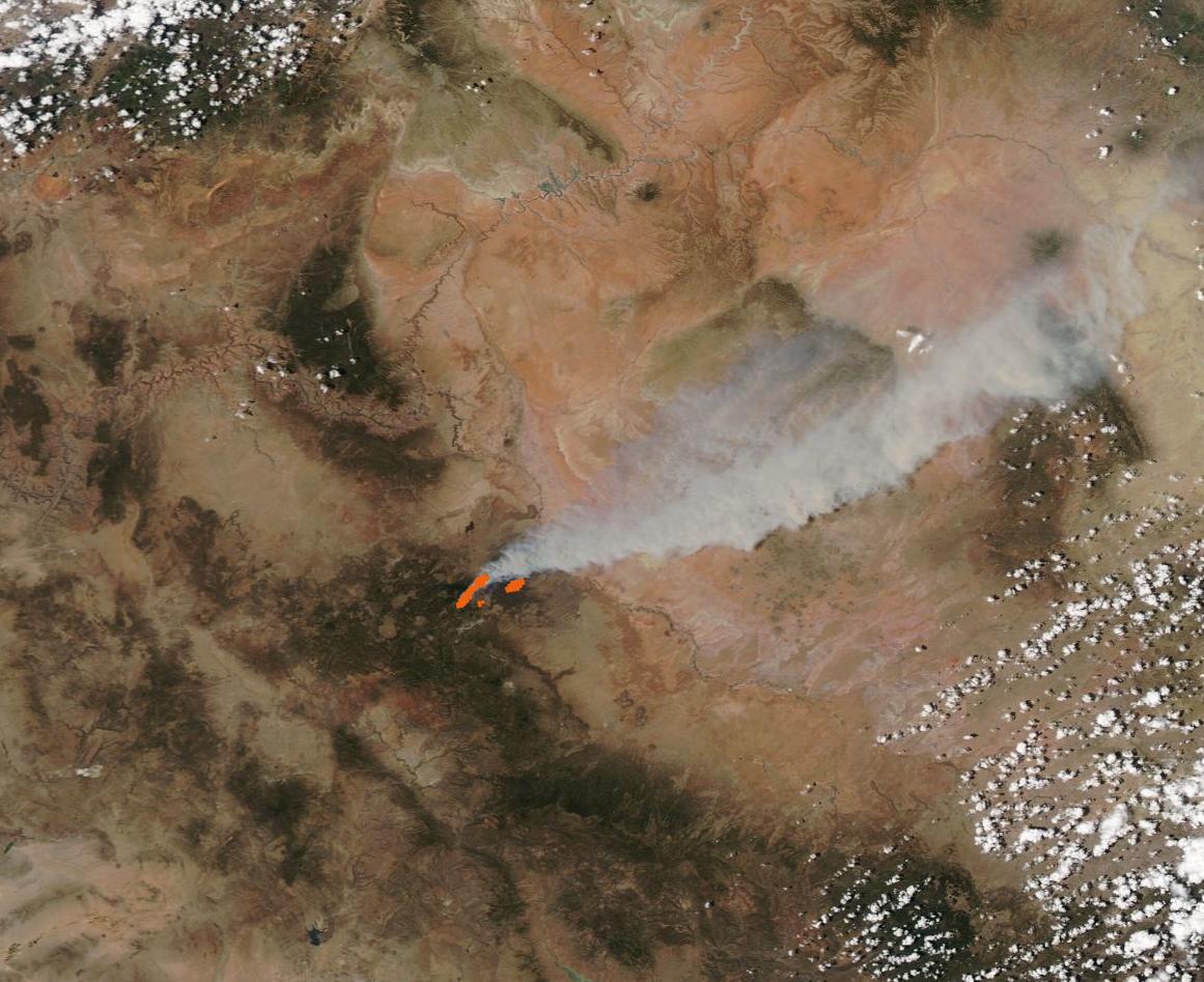
Three fires ignited in tinder-dry conditions Arizona’s Coconino National Forest north and northeast of Flagstaff on June 12, 2022. High temperatures, humidity as low as six percent, and wind gusts reported as high as 49 mph (74 km/h) fed extreme fire behavior.
The Pipeline Fire was first seen by a fire lookout around 10:15 a.m. local time on June 12. By the evening of June 13, the fire had spread to scorch 5,000 acres and triggered evacuations. At 11:00 p.m. EDT on June 12, the Coconino County Situational Awareness Viewer noted the following areas in Evacuation Status Go: Areas of Schultz Pass Road and Arizona Snowbowl, Timberline, Crater Estates Area, O’Leary, McCann Estates, and Doney Park North. Areas in Evacuation Status Set: Mt Elden Lookout Road/Mt Elden Estates, Doney Park South, and Antelope Hills. A status report on InciWeb Incident Information System states “Exact size of wildfire is currently unknown since it is continually growing. Infrared flyovers help provide a more accurate estimation, which are usually conducted at night.” The cause of the Pipeline Fire is officially listed as “under investigation”, a news article published on InciWeb on June 12 stated that a 57-year-old male was arrested by Forest Service law enforcement officials in connection with the wildfire and charged with natural resource violations. No further details of the investigation were given.
The Moderate Resolution Imaging Spectroradiometer (MODIS) on board NASA’s Aqua satellite acquired a true-color image of the Pipeline Fire on June 13. Red “hot spots” mark where the thermal bands on the instrument detected high temperatures. Combined with the typical gray smoke plume, those hot sports mark actively burning fire. Smoke is blowing strongly to the northeast, pushed by strong winds.
Since this image was acquired, two additional fires were spotted, each burning to the northeast of the Pipeline Fire and in the area that is under smoke in this image. The Haywire Fire was first reported at about 5:13 a.m. on June 13. It is burning about seven miles northeast of the Pipeline Fire and is thought to have originated from a lightning strike although the cause is still under investigation. As of the evening of June 13, the Haywire Fire reached 1,600 acres in size. The Double fire was spotted at about 4:13 on the afternoon of June 12 and also thought to be caused by lightning strike. It is located about two miles south of the Haywire Fire and is about 500 acres in size. It is expected that the Haywire and Double Fires will soon combine.
The three fires are burning around the burn scar of the Tunnel Fire, a blaze that began on April 17 and consumed 19,088 acres north of Flagstaff before it was fully contained on June 3. The Pipeline Fire appears to have reached the southwestern side of the Tunnel Fire while the Haywire and Double Fires are close to the northeastern side.
Image Facts
Satellite:
Aqua
Date Acquired: 6/13/2022
Resolutions:
1km (48.3 KB), 500m (164 KB), 250m (512.9 KB)
Bands Used: 1,4,3
Image Credit:
MODIS Land Rapid Response Team, NASA GSFC
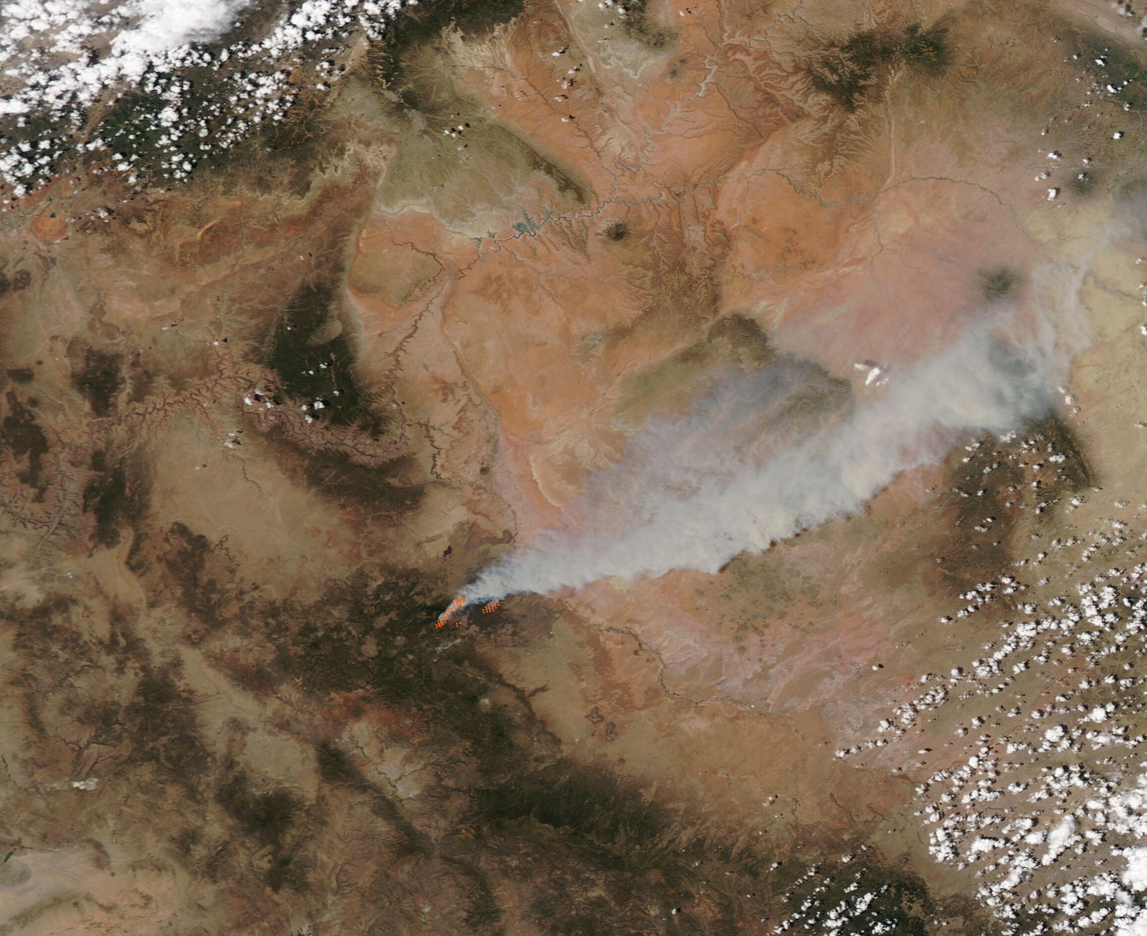
