Images
June 18, 2022 - Hurricane Blas
Tweet
The second named storm of the Pacific hurricane season formed on June 14, 2022, off the west coast of Mexico. That morning, the National Hurricane Center (NHC) named the system Tropical Storm Blas and reported maximum sustained winds had reached 45 mph (75 km/h). At that time, Blas was located about 380 miles (615 km) south-southeast of Manzanillo, Mexico. The system was expected to strengthen but was also expected to move out towards open ocean, creating no serious risk to land.
The storm quickly intensified, reaching hurricane strength only 24 hours later, sporting maximum sustained winds of 75 mph (120 km/h) in the morning of June 15. It was continuing to move west-northwest. Hurricane Blas has retained Category 1 hurricane status through the afternoon of June 17, with peak winds of 90 mph (145 km/h) reached on the afternoon of June 17.
Not long afterward, Hurricane Blas began to move into an increasingly unfavorable environment with more stable and dry air. By 5:00 p.m. EDT (2100 UTC) on that date, the NHC reported that Hurricane Blas sported winds of 85 mph (140 km/h) and was located about 380 mi (610 km) south of the southern tip of Baja California and was moving westward, away from land. Hurricane-force winds extended outward up to 15 miles (30 km) from the storm’s center. Blas is expected to steadily weaken and reach tropical storm strength on June 18. The NHC advised that swells generated by Blas will continue to affect the southwest coast of Mexico and the southern portion of the Baja California peninsula during the next day or two. The swells could cause life-threatening surf and rip current conditions.
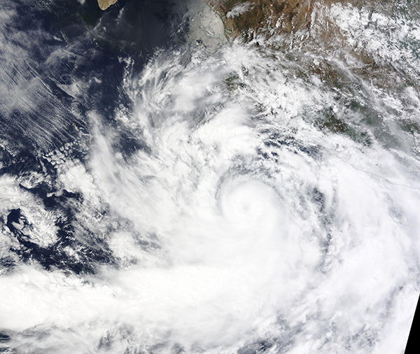
The Moderate Resolution Imaging Spectroradiometer (MODIS) on board NASA’s Terra satellite acquired a true-color image of Hurricane Blas on July 16. At that time, maximum sustained winds were about 85 mph (137 km/h) and the storm sported a distinct cloud-filled eye and an apostrophe-shape created by convective bands wrapping into the center. In the northeast quadrant, bands carrying rain and winds were interacting with the coastal regions of the Mexican states of Guerrero, Michoacan, Colima, and Jalisco. Several ports were closed as a precaution due to stormy weather, even though the eye of the storm was moving away from land.
Image Facts
Satellite:
Terra
Date Acquired: 6/16/2022
Resolutions:
1km (1.6 MB), 500m (4.6 MB), 250m (3.1 MB)
Bands Used: 1,4,3
Image Credit:
MODIS Land Rapid Response Team, NASA GSFC


