
Images


July 6, 2022 - Tropical Storm Aere
 Tweet
Tweet
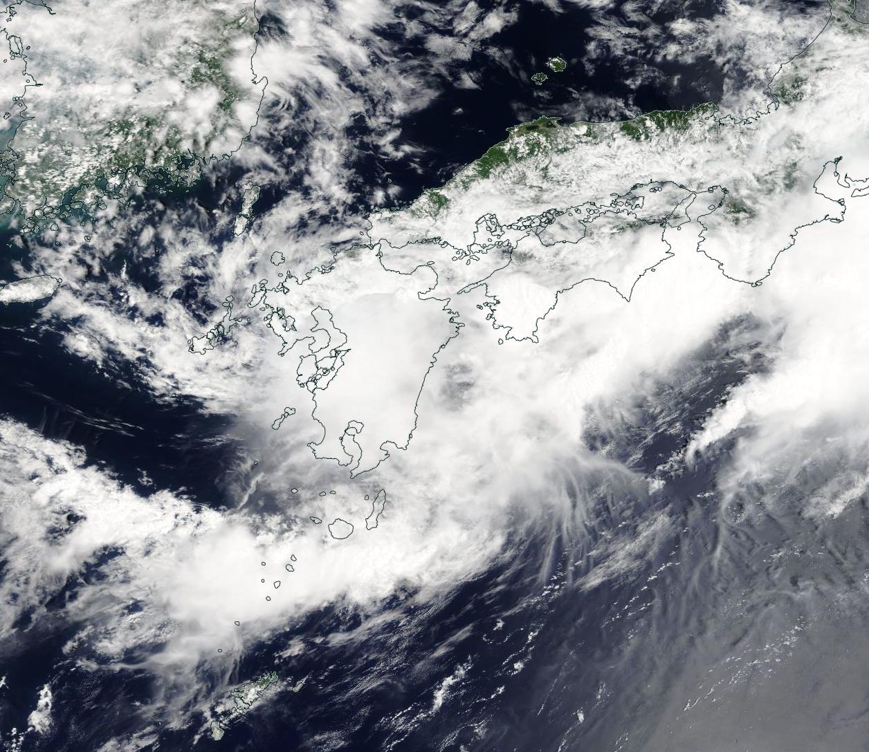
Tropical Storm Aere, the fourth named storm of the Pacific Typhoon Season, made landfall over Okinawa, Japan on July 2, 2022, coming ashore with maximum sustained winds measuring about 45 mph (73 km/h). According to Reliefweb, at least two people were injured in Okinawa and several rivers reached flood warning levels. It then took aim at Kyushu, the third-largest of Japan’s islands.
After leaving Okinawa, a weakened Aere crossed the East China Sea as a tropical depression. Unable to restrengthen, the storm made a second landfall near Sasebo, Nagasaki, Kyushu in the early morning hours of July 5 local time. Despite carrying maximum sustained winds of just 34 mph (55 km/h), Aere carried record-breaking rainfall which triggered landslides and flooding. The Japan Meteorological Agency (JMA) reported that Unzen, Nagasaki Prefecture, Arao, Kumamoto Prefecture, and Omuta, Fukuoka Prefecture—all on Kyushu—received an estimated 120 mm (4.7) inches or more in just one hour. As the storm moves northeastward, it has been forecast that the western part of the main island of Shikoku could receive 200 mm (7.9 inches) over the next 24 hours.
At 11:00 p.m. EDT on July 5 (0300 UTC on July 6), the Joint Typhoon Warning Center (JWTC) reported that Tropical Depression Aere carried maximum sustained winds near 30 mph (48 km/h) with gusts to 40 mph (64 km/h). It was located about 138 miles (222 km) south-southwest of Yokosuka, Japan and was tracking eastward over open water.
JTWC forecasts that the storm will continue to move eastward before merging with a low pressure system currently developing east of Honshu on July 6. This is likely to cause quick intensification, allowing Aere to gain just a little strength over the next 24 hours before stalling and weakening by July 8.
The Moderate Resolution Imaging Spectroradiometer (MODIS) on board NASA’s Terra satellite acquired a true-color image of Tropical Depression Aere as it moved over Kyushu on July 5. The large and ragged storm sported a cloud-filled center of circulation located over Kyushu while convective bands associated with the storm reached far northwest over the island of Shikoku, bringing rain across a swath of more than 300 miles (483 km).
Image Facts
Satellite:
Terra
Date Acquired: 7/5/2022
Resolutions:
1km (241.1 KB), 500m (749.7 KB), 250m (2.2 MB)
Bands Used: 1,4,3
Image Credit:
MODIS Land Rapid Response Team, NASA GSFC
Tropical Storm Aere, the fourth named storm of the Pacific Typhoon Season, made landfall over Okinawa, Japan on July 2, 2022, coming ashore with maximum sustained winds measuring about 45 mph (73 km/h). According to Reliefweb, at least two people were injured in Okinawa and several rivers reached flood warning levels. It then took aim at Kyushu, the third-largest of Japan’s islands.
After leaving Okinawa, a weakened Aere crossed the East China Sea as a tropical depression. Unable to restrengthen, the storm made a second landfall near Sasebo, Nagasaki, Kyushu in the early morning hours of July 5 local time. Despite carrying maximum sustained winds of just 34 mph (55 km/h), Aere carried record-breaking rainfall which triggered landslides and flooding. The Japan Meteorological Agency (JMA) reported that Unzen, Nagasaki Prefecture, Arao, Kumamoto Prefecture, and Omuta, Fukuoka Prefecture—all on Kyushu—received an estimated 120 mm (4.7) inches or more in just one hour. As the storm moves northeastward, it has been forecast that the western part of the main island of Shikoku could receive 200 mm (7.9 inches) over the next 24 hours.
At 11:00 p.m. EDT on July 5 (0300 UTC on July 6), the Joint Typhoon Warning Center (JWTC) reported that Tropical Depression Aere carried maximum sustained winds near 30 mph (48 km/h) with gusts to 40 mph (64 km/h). It was located about 138 miles (222 km) south-southwest of Yokosuka, Japan and was tracking eastward over open water. JTWC forecasts that the storm will continue to move eastward before merging with a low pressure system currently developing east of Honshu on July 6. This is likely to cause quick intensification, allowing Aere to gain just a little strength over the next 24 hours before stalling and weakening by July 8.
The Moderate Resolution Imaging Spectroradiometer (MODIS) on board NASA’s Terra satellite acquired a true-color image of Tropical Depression Aere as it moved over Kyushu on July 5. The large and ragged storm sported a cloud-filled center of circulation located over Kyushu while convective bands associated with the storm reached far northwest over the island of Shikoku, bringing rain across a swath of more than 300 miles (483 km).
Image Facts
Satellite:
Terra
Date Acquired: 7/5/2022
Resolutions:
1km (241.1 KB), 500m (749.7 KB), 250m (2.2 MB)
Bands Used: 1,4,3
Image Credit:
MODIS Land Rapid Response Team, NASA GSFC
