
Images


July 11, 2022 - Flooding from Heavy Rains in Western Pakistan
 Tweet
Tweet
Pakistan sits at the crossroads of Asia and the Middle East, nestled between India (east), Iran and Afghanistan (west), and China to the north. One of the longest rivers in the world, the Indus River, rises from glaciers in the Himalaya and Karakoram mountain ranges, flows southward through Pakistan, then empties into the Arabian Sea.
The ebb and flow of the Indus—indeed the ebb and flow of life throughout the region—depends on both temperature and rainfall. Rain is lowest in the cool, dry winter (December to February) and through much of the hot, dry spring (March through May). The springtime heat brings glacial melt and is followed by monsoonal rains which peak from July through September, and retreat in October to November.
Pakistan often suffers from drought, especially in times of rising temperatures. In May of 2022, the United Nations listed Pakistan among 23 countries which are facing drought emergencies during 2020-2022. On top of ongoing drought, a fierce heatwave struck Pakistan this spring, leading to the hottest March recorded in India since 1901. Temperatures in Nawabshahn reached 49.5˚C (121˚F) in March while two other cities, Jacobabad and Sibi, reached 47˚C (117˚F). Jacobabad broke its newly-set record in April, when temperatures reached 49˚C (120.2˚F) The extreme heat melted so much ice on Shisper Glacier that it created a lake, which subsequently flooded. This glacier lake outburst flood was so strong that in early May it triggered the collapse of the Hassanabad Bridge on the Karakorum Highway in the Hunza Valley.
The dangerous heatwave was followed by the second-driest April in Pakistan since 1961. Rainfall in April was reported to be about 74 percent below normal across the country, especially in Punjab, which was said to have received 89 percent less rain than average. Yet rainfall did occur in some areas, and was unpredictably severe at times. For example, on April 21, the town of Larkana in the Sindh region received 38 mm (1.5 inches) of rain, along with a hailstorm—said to be the first hailstorm ever recorded in Larkana in April.
Despite the drought and in part because of glacier-melting heat, localized flooding was reported in several parts of the country as early as May, even before monsoonal rains began. Floods have continued through June and became more widespread and severe by July. On July 4, torrential rains began to pour on Balochistan Province. By July 9, media reported at that eight dams had burst due to the monsoonal storms, with at least 57 people killed and hundreds left homeless in that region. According to a government report published by Reliefweb, as of July 10, 147 people have been killed and 160 injured due to flooding across Pakistan since June 14.
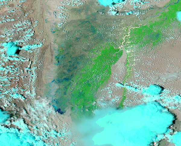
On July 8, 2022, the Moderate Resolution Imaging Spectroradiometer (MODIS) on board NASA’s Aqua satellite acquired a false-color image of flooding in western Pakistan. In this type of image, infrared and visible light are combined to help separate water (deep blue) and vegetation (bright green). Clouds can appear white or bright blue.
The image reveals a widespread swath of bright vegetation along the plains of the Indus River. The Indus itself is filled with muddy sediment along much of its winding course, likely carried from flooding and glacial meltwaters to the north. To the west of the green plains, the land of Blochistan province is painted in blue. Not only are rivers overflowing, but the water is so widespread that some localities appear to almost be marshland. The area covered by floodwaters, as measured through the NASA Worldview App, extends for more than 13,000 square kilometers (5,020 square miles).
Image Facts
Satellite:
Aqua
Date Acquired: 7/8/2022
Resolutions:
1km (224.2 KB), 500m (403.1 KB), 250m (343.2 KB)
Bands Used: 7,2,1
Image Credit:
MODIS Land Rapid Response Team, NASA GSFC
Pakistan sits at the crossroads of Asia and the Middle East, nestled between India (east), Iran and Afghanistan (west), and China to the north. One of the longest rivers in the world, the Indus River, rises from glaciers in the Himalaya and Karakoram mountain ranges, flows southward through Pakistan, then empties into the Arabian Sea.
The ebb and flow of the Indus—indeed the ebb and flow of life throughout the region—depends on both temperature and rainfall. Rain is lowest in the cool, dry winter (December to February) and through much of the hot, dry spring (March through May). The springtime heat brings glacial melt and is followed by monsoonal rains which peak from July through September, and retreat in October to November.
Pakistan often suffers from drought, especially in times of rising temperatures. In May of 2022, the United Nations listed Pakistan among 23 countries which are facing drought emergencies during 2020-2022. On top of ongoing drought, a fierce heatwave struck Pakistan this spring, leading to the hottest March recorded in India since 1901. Temperatures in Nawabshahn reached 49.5˚C (121˚F) in March while two other cities, Jacobabad and Sibi, reached 47˚C (117˚F). Jacobabad broke its newly-set record in April, when temperatures reached 49˚C (120.2˚F) The extreme heat melted so much ice on Shisper Glacier that it created a lake, which subsequently flooded. This glacier lake outburst flood was so strong that in early May it triggered the collapse of the Hassanabad Bridge on the Karakorum Highway in the Hunza Valley.
The dangerous heatwave was followed by the second-driest April in Pakistan since 1961. Rainfall in April was reported to be about 74 percent below normal across the country, especially in Punjab, which was said to have received 89 percent less rain than average. Yet rainfall did occur in some areas, and was unpredictably severe at times. For example, on April 21, the town of Larkana in the Sindh region received 38 mm (1.5 inches) of rain, along with a hailstorm—said to be the first hailstorm ever recorded in Larkana in April.
Despite the drought and in part because of glacier-melting heat, localized flooding was reported in several parts of the country as early as May, even before monsoonal rains began. Floods have continued through June and became more widespread and severe by July. On July 4, torrential rains began to pour on Balochistan Province. By July 9, media reported at that eight dams had burst due to the monsoonal storms, with at least 57 people killed and hundreds left homeless in that region. According to a government report published by Reliefweb, as of July 10, 147 people have been killed and 160 injured due to flooding across Pakistan since June 14.
On July 8, 2022, the Moderate Resolution Imaging Spectroradiometer (MODIS) on board NASA’s Aqua satellite acquired a false-color image of flooding in western Pakistan. In this type of image, infrared and visible light are combined to help separate water (deep blue) and vegetation (bright green). Clouds can appear white or bright blue.
The image reveals a widespread swath of bright vegetation along the plains of the Indus River. The Indus itself is filled with muddy sediment along much of its winding course, likely carried from flooding and glacial meltwaters to the north. To the west of the green plains, the land of Blochistan province is painted in blue. Not only are rivers overflowing, but the water is so widespread that some localities appear to almost be marshland. The area covered by floodwaters, as measured through the NASA Worldview App, extends for more than 13,000 square kilometers (5,020 square miles).
Image Facts
Satellite:
Aqua
Date Acquired: 7/8/2022
Resolutions:
1km (224.2 KB), 500m (403.1 KB), 250m (343.2 KB)
Bands Used: 7,2,1
Image Credit:
MODIS Land Rapid Response Team, NASA GSFC
