
Images


July 15, 2022 - Fires in South Africa and Mozambique
 Tweet
Tweet
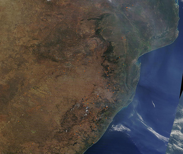
Dozens of fires and copious smoke covered portions of southeastern Africa in mid-July 2022. The Moderate Resolution Imaging Spectroradiometer (MODIS) on board NASA’s Terra satellite acquired a true-color image of the smoky scene on July 14.
The countries captured in this image include Mozambique (north), which is roughly covered by a shroud of blue-tinted smoke, Eswatini (formerly Swaziland), northeastern South Africa (south), and Lesotho. Many red “hot spots”, each indicating fire, are found in Mozambique, but most are spread across South Africa. Eswatini, a small country that sits on the border between Mozambique and South Africa, roughly near the southern edge of the smoke and a break in the mountain ridge, appears to have only has one or two fires burning near its borders. Lesotho, which sits southwest of Eswatini and is completely surrounded by South Africa, has zero fires evident.
While it is not possible to determine the cause of the fires nor if they are wildfires or deliberately set or managed simply by looking at a satellite image, given the time of year, location, and widespread nature of the fires it is likely that most are agricultural fires—fires that are used to manage cropland or pasture.
Image Facts
Satellite:
Terra
Date Acquired: 7/14/2022
Resolutions:
1km (195.2 KB), 500m (722.6 KB), 250m (2.4 MB)
Bands Used: 1,4,3
Image Credit:
MODIS Land Rapid Response Team, NASA GSFC
