
Images


July 19, 2022 - Nile River Delta
 Tweet
Tweet
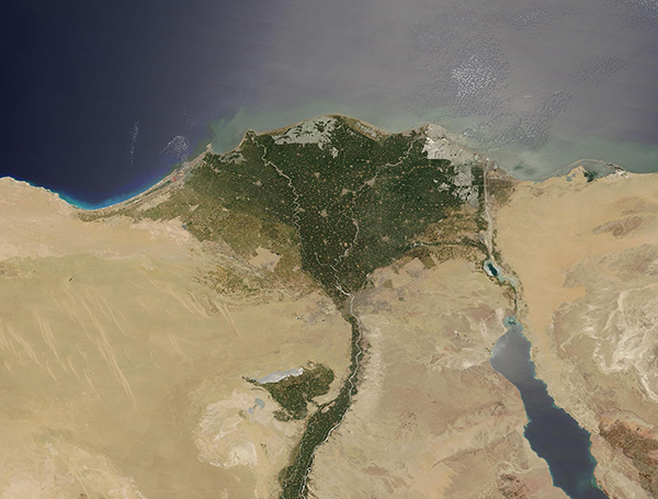
A shining swath of sunglint highlighted the waters near Egypt’s Nile River Delta in mid-July 2022. The Moderate Resolution Imaging Spectroradiometer (MODIS) on board NASA’s Terra satellite acquired a true-color image of the broad delta and shimmering sea on July 17.
The Nile River is the longest river in the world, extending about 6,700 kilometers (4,160 miles) from its headwaters in the highland of eastern Africa to the shores of the Mediterranean Sea. The fertile soils along the Nile River and expansive delta region support the country’s agriculture, as well as providing home for 95 percent of Egypt’s population.
As the Nile River approaches the Mediterranean coast, the river splits into two main branches. The Rosetta River flows westward and the Damietta heads eastward. By the time these branches reach the Mediterranean Sea, they sit about 87 miles (140 km) apart, and create a wide, green floodplain. The Delta spans roughly 10,039 square miles (26,000 square km), creating vast green oasis in an extremely arid region.
In this image, the waters of the Mediterranean Sea appears deep blue in the west, but a silvery-gray across the rest of the image. This silvery gleam is caused by sunglint, an optical phenomenon that occurs when sunlight reflects off the surface of water at the same angle that a satellite sensor views it. It’s much like what happens when you look at a mirror with the Sun almost directly behind you—you get dazzled by the bright reflection of the light off the smooth surface.
Sunglint highlights not only part of the Mediterranean Sea, but also many other water features. Both the Rosetta and Damietta Rivers, as well as the Nile itself are glowing silver. Two large lakes Mediterranean coast—Lake Burullus (west) and Al Manzalah Lake wear a sheen of silver. Just east of Port Said, the Suez Canal, connecting the Mediterranean to the Gulf of Suez and ultimately the Red Sea, is also highlighted.
Image Facts
Satellite:
Terra
Date Acquired: 7/17/2022
Resolutions:
1km (221.8 KB), 500m (628.6 KB), 250m (377.9 KB)
Bands Used: 1,4,3
Image Credit:
MODIS Land Rapid Response Team, NASA GSFC
