
Images


July 29, 2022 - Water in Lake Gairdner
 Tweet
Tweet
South Australia is considered to be the driest of all the Australian states, with annual rainfall topping 10 inches (250 mm) in only about one-fifth of the region. Summertime (December to February) is the driest and hottest season, with most rainfall in winter (June to August).
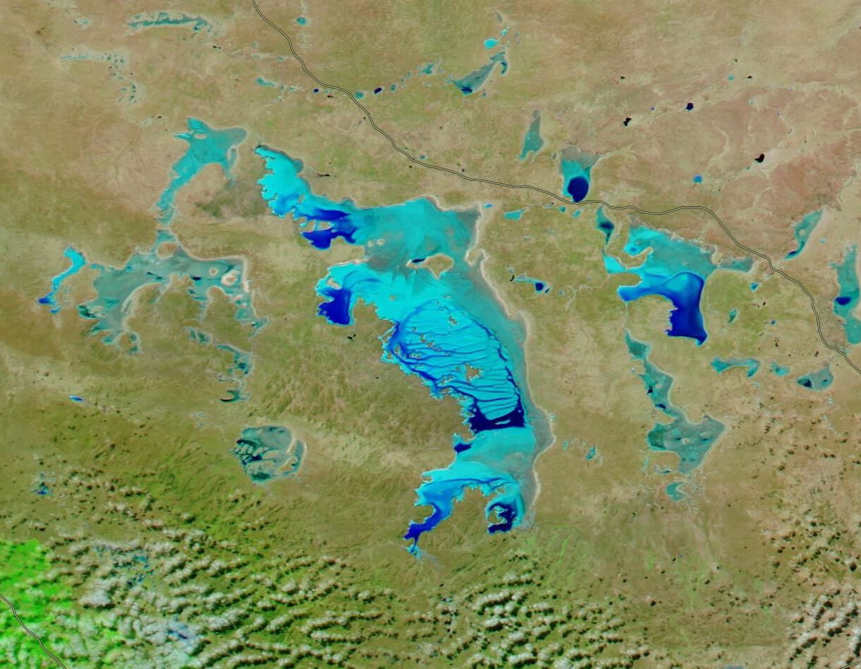
As a result of the hot, dry climate, the landscape of South Australia is speckled with salt lakes, most of which are little more than rarely-moistened, mineral-crusted depressions. Many of these are found north of the Eyre Peninsula, surrounded by the red sand hills near the Gawler Ranges. The largest of these lakes—indeed the third-largest salt lake in Australia—is Lake Gairdner. Lake Gairdner, along with Lakes Harris and Everard, are so unique that they are protected as part of Australia’s Lake Gairdner National Park.
The bone-dry, extremely flat surface of Lake Gairdner is a place where land speed records are set by cars, trucks, motorcycles, and even wind-driven land yachts. It’s also the location where enthusiasts meet to see just how fast they can accelerate on “the big white dyno”, especially during the Dry Lakes Racer’s Australia (DLRA) “Speed Week” held at the end of each summer, when conditions on the giant salt flat is always perfect. Always—except for this year. In 2022, Lake Gairdner was under water. On February 1, the DLRA cancelled the event, citing that the lake was under about 500 mm (19.7 in) of “very dirty water”.
South Australia suffered an extremely wet summer. On January 22, 2022, multiple media outlets reported a “once in a lifetime” rain event, which dumped 181 mm (7.1 in) at Mt. Ive in three days, which was sixty percent more than its annual average. The Australian Bureau of Meteorology (BOM) was quoted as saying that several spots in the state had received “all-time” highest recorded rainfall totals over 24 hours, with at least seven of those located near the Eyre Peninsula. A section of the Olympic Dam Highway, a road that runs north of Lake Gairdner, was washed away. The BOM attributed the rare summer deluge, at least in part, to tropical moisture brought to Australia by then ex-Tropical Cyclone Tiffany, which had crossed the northern part of the country shortly prior to the southern downpours.
The torrential rainfall also filled all of the normally salt-encrusted lakes in the region, including Lake Gairdner. While rain patterns have returned to nearly normal since January, the South Australian salt lakes have been slow to dry up. Evaporating is occurring, with estimates of up to 100 mm (3.9 in) a month. But it will still be several weeks or months before the “big white dyno” is ready to ride.
On July 26, 2022, the Moderate Resolution Imaging Spectroradiometer (MODIS) on board NASA’s Aqua satellite acquired a false-color image showing water-rich salt lakes. The image is centered on Lake Gairdner. To the northwest of Gairdner is Lake Harris and to the southwest is Lake Everard. Island Lagoon is the largest lake to the east of Gairdner.
In this type of false-color image, a combination of infrared and visible light (MODIS bands 7,2,1) are used help highlight water. Here, vegetation appears in shades of green, with dense vegetation looking very bright green, while open land is colored in shades of tan. The Olympic Dam Highway, crossing the image in the northeast, is shaded a gray-brown. Water within the salt lakes is colored blue, but the shade varies depending on the depth. The deepest water is the darkest blue and areas that are very shallow, where only a small amount of water mixes in with the highly-reflective mineral crust, appear milky-blue. Where a thin layer of water sits over the salt layer, or the salt is thoroughly saturated, the blue tones tend to be a little muddier or duller. White appears along the edge of most of the lakes, where the water has completely dried to leave only mineral crust.
Image Facts
Satellite:
Aqua
Date Acquired: 7/26/2022
Resolutions:
1km (127.3 KB), 500m (310.2 KB), 250m (172.7 KB)
Bands Used: 7,2,1
Image Credit:
MODIS Land Rapid Response Team, NASA GSFC
South Australia is considered to be the driest of all the Australian states, with annual rainfall topping 10 inches (250 mm) in only about one-fifth of the region. Summertime (December to February) is the driest and hottest season, with most rainfall in winter (June to August).
As a result of the hot, dry climate, the landscape of South Australia is speckled with salt lakes, most of which are little more than rarely-moistened, mineral-crusted depressions. Many of these are found north of the Eyre Peninsula, surrounded by the red sand hills near the Gawler Ranges. The largest of these lakes—indeed the third-largest salt lake in Australia—is Lake Gairdner. Lake Gairdner, along with Lakes Harris and Everard, are so unique that they are protected as part of Australia’s Lake Gairdner National Park.
The bone-dry, extremely flat surface of Lake Gairdner is a place where land speed records are set by cars, trucks, motorcycles, and even wind-driven land yachts. It’s also the location where enthusiasts meet to see just how fast they can accelerate on “the big white dyno”, especially during the Dry Lakes Racer’s Australia (DLRA) “Speed Week” held at the end of each summer, when conditions on the giant salt flat is always perfect. Always—except for this year. In 2022, Lake Gairdner was under water. On February 1, the DLRA cancelled the event, citing that the lake was under about 500 mm (19.7 in) of “very dirty water”.
South Australia suffered an extremely wet summer. On January 22, 2022, multiple media outlets reported a “once in a lifetime” rain event, which dumped 181 mm (7.1 in) at Mt. Ive in three days, which was sixty percent more than its annual average. The Australian Bureau of Meteorology (BOM) was quoted as saying that several spots in the state had received “all-time” highest recorded rainfall totals over 24 hours, with at least seven of those located near the Eyre Peninsula. A section of the Olympic Dam Highway, a road that runs north of Lake Gairdner, was washed away. The BOM attributed the rare summer deluge, at least in part, to tropical moisture brought to Australia by then ex-Tropical Cyclone Tiffany, which had crossed the northern part of the country shortly prior to the southern downpours.
The torrential rainfall also filled all of the normally salt-encrusted lakes in the region, including Lake Gairdner. While rain patterns have returned to nearly normal since January, the South Australian salt lakes have been slow to dry up. Evaporating is occurring, with estimates of up to 100 mm (3.9 in) a month. But it will still be several weeks or months before the “big white dyno” is ready to ride.
On July 26, 2022, the Moderate Resolution Imaging Spectroradiometer (MODIS) on board NASA’s Aqua satellite acquired a false-color image showing water-rich salt lakes. The image is centered on Lake Gairdner. To the northwest of Gairdner is Lake Harris and to the southwest is Lake Everard. Island Lagoon is the largest lake to the east of Gairdner.
In this type of false-color image, a combination of infrared and visible light (MODIS bands 7,2,1) are used help highlight water. Here, vegetation appears in shades of green, with dense vegetation looking very bright green, while open land is colored in shades of tan. The Olympic Dam Highway, crossing the image in the northeast, is shaded a gray-brown. Water within the salt lakes is colored blue, but the shade varies depending on the depth. The deepest water is the darkest blue and areas that are very shallow, where only a small amount of water mixes in with the highly-reflective mineral crust, appear milky-blue. Where a thin layer of water sits over the salt layer, or the salt is thoroughly saturated, the blue tones tend to be a little muddier or duller. White appears along the edge of most of the lakes, where the water has completely dried to leave only mineral crust.
Image Facts
Satellite:
Aqua
Date Acquired: 7/26/2022
Resolutions:
1km (127.3 KB), 500m (310.2 KB), 250m (172.7 KB)
Bands Used: 7,2,1
Image Credit:
MODIS Land Rapid Response Team, NASA GSFC
