
Images


August 17, 2022 - Tropical Disturbance Over Texas
 Tweet
Tweet
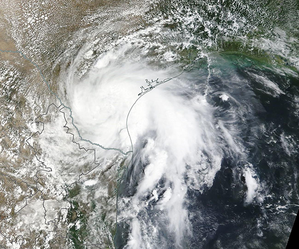
On the afternoon of August 11, 2022, the National Hurricane Center (NHC) flagged a disorganized low forming south of Louisiana over the Gulf of Mexico as Invest 98L. At that time, the system was carrying maximum sustained winds of about 25 mph (40.2 km/h) and moving westward. The NHC gave the system only a ten percent chance of developing into a tropical storm as it crossed the Gulf, taking aim at Texas.
According to the NHC, the term “Invest” is defined as, "A weather system for which a tropical cyclone forecast center (NHC, CPHC, or JTWC) is interested in collecting specialized data sets (e.g., microwave imagery) and/or running model guidance…The designation of a system as an invest does not correspond to any particular likelihood of development of the system into a tropical cyclone".
By the afternoon of August 13, the leading edge of Invest 98L was already bringing rain and high surf to the southern Texas coast. The system began to gain strength, with maximum sustained winds reached 30 mph (48.3 km/h), but it still lacked the organization or wind speed to become a named storm.
On August 14, the center of 98L made landfall south of Corpus Christi bringing soaking rains but relatively mild winds to drought-stricken southern Texas from Corpus Christi to the Rio Grande Valley. According to local media, torrential rain struck some locations, bringing up to 12 inches (2.5 cm) of precipitation in a few hours. Rainfall totals were highest in Encino, where 16.1 inches (40.9 cm) were reported to have fallen in 24 hours. Much of Texas has suffering long-standing drought, with 68.21 percent of the state in either Exceptional (D-4) drought or Extreme (D3) drought. The heavy rains have likely helped relieve the drought in the southeastern corner of that state.
On August 14, the Moderate Resolution Imaging Spectroradiometer (MODIS) on board NASA’s Terra satellite acquired a true-color image of the rain-making Invest 98L over southeastern Texas. At first glance, it looks much like a weak tropical storm, but lacks a distinct eye and only weak convective banding can be seen. The system dissipated after bringing much-needed rainfall and minor flooding to the region.
Image Facts
Satellite:
Terra
Date Acquired: 8/14/2022
Resolutions:
1km (316.4 KB), 500m (1 MB), 250m (3.1 MB)
Bands Used: 1,4,3
Image Credit:
MODIS Land Rapid Response Team, NASA GSFC
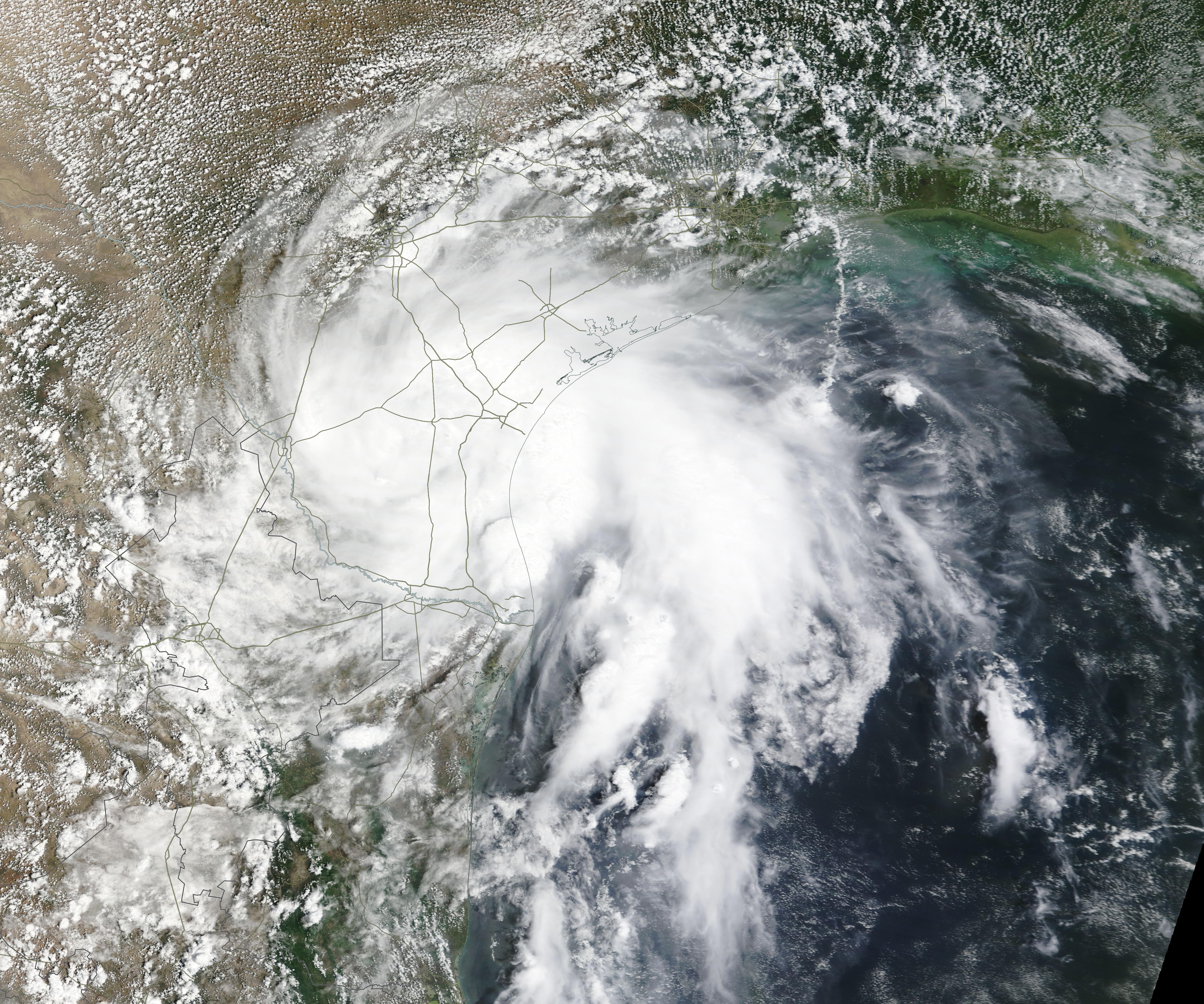
On the afternoon of August 11, 2022, the National Hurricane Center (NHC) flagged a disorganized low forming south of Louisiana over the Gulf of Mexico as Invest 98L. At that time, the system was carrying maximum sustained winds of about 25 mph (40.2 km/h) and moving westward. The NHC gave the system only a ten percent chance of developing into a tropical storm as it crossed the Gulf, taking aim at Texas. According to the NHC, the term “Invest” is defined as, "A weather system for which a tropical cyclone forecast center (NHC, CPHC, or JTWC) is interested in collecting specialized data sets (e.g., microwave imagery) and/or running model guidance…The designation of a system as an invest does not correspond to any particular likelihood of development of the system into a tropical cyclone".
By the afternoon of August 13, the leading edge of Invest 98L was already bringing rain and high surf to the southern Texas coast. The system began to gain strength, with maximum sustained winds reached 30 mph (48.3 km/h), but it still lacked the organization or wind speed to become a named storm.
On August 14, the center of 98L made landfall south of Corpus Christi bringing soaking rains but relatively mild winds to drought-stricken southern Texas from Corpus Christi to the Rio Grande Valley. According to local media, torrential rain struck some locations, bringing up to 12 inches (2.5 cm) of precipitation in a few hours. Rainfall totals were highest in Encino, where 16.1 inches (40.9 cm) were reported to have fallen in 24 hours. Much of Texas has suffering long-standing drought, with 68.21 percent of the state in either Exceptional (D-4) drought or Extreme (D3) drought. The heavy rains have likely helped relieve the drought in the southeastern corner of that state.
On August 14, the Moderate Resolution Imaging Spectroradiometer (MODIS) on board NASA’s Terra satellite acquired a true-color image of the rain-making Invest 98L over southeastern Texas. At first glance, it looks much like a weak tropical storm, but lacks a distinct eye and only weak convective banding can be seen. The system dissipated after bringing much-needed rainfall and minor flooding to the region.
Image Facts
Satellite:
Terra
Date Acquired: 8/14/2022
Resolutions:
1km (316.4 KB), 500m (1 MB), 250m (3.1 MB)
Bands Used: 1,4,3
Image Credit:
MODIS Land Rapid Response Team, NASA GSFC
