
Images


August 30, 2022 - Deadly Flooding in Pakistan
Tweet
Severe monsoon rains have battered Pakistan since mid-June 2022, creating a massive disaster that has affected about 30 million people. According to the Pakistan National Disaster Management Authority (NDMA), as of August 29 an estimated 1,136 people have died since June 14 and additional 1,634 have been injured. Floodwaters have damaged more than 3,400 km (2,113 miles) of roads—more than the straight-line north-to-south distance across the United States from its border with Alberta, Canada and the Mexico border. The NDMA reported that 162 bridges and 170 shops have been damaged and 735,375 livestock have died.
Reliefweb, a publication of the UN Office for the Coordination of Humanitarian Affairs (OCHA) states that floods have affected Balochistan, Sindh, Gilgit-Baltistan, Punjab, Azad Jammu and Kashmir, and Khyber Pakhtunkhwa (KPK) provinces of Pakistan. As of August 29, they report that around 1 million houses are totally or partially damaged, leaving behind millions in need of urgent shelter.
The weather forecast calls for mainly dry weather over most of Pakistan for the next 24 hours. However, isolated thunderstorm activity and rain is expected along the upper catchment of all major rivers in the country, and this may add to flood conditions over the next several days.
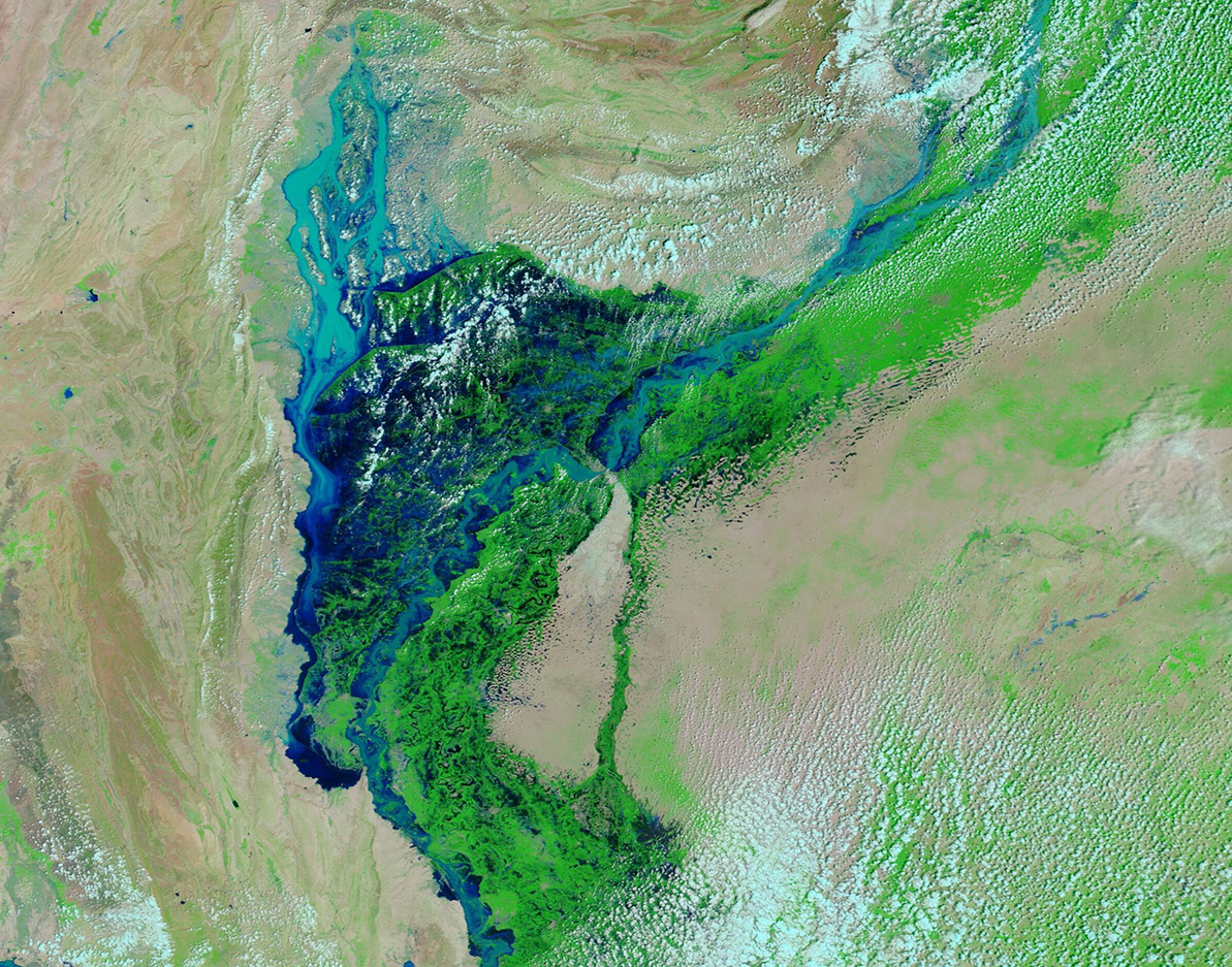
Today’s Image of the Day is a roll-over comparison of two false-color images of the Indus River and adjacent floodplain in the Sindh province of Pakistan. The two images were acquired by the Moderate Resolution Imaging Spectroradiometer (MODIS) on board NASA’s Terra satellite on two different days—August 27, 2022, and August 27, 2021. The comparison is provided by NASA’s Worldview App. To best use the roll-over feature, click on the arrow and slide your cursor to the right or left. Clicking on either image will allow moving only the image, with the comparison bar remaining stationary.
This type of false-color image uses infrared and visible light (MODIS bands 7,2,1) to help distinguish water from land. Water appears various shades of blue, depending on depth and any sediment in the water, with the deepest water looking the darkest. Vegetation looks bright green while open or sparsely vegetated land looks tan. Cloud ranges from white to electric blue.
These images clearly show the difference between the more normal monsoon season of 2021, when the flood plains near the Indus were green and the river remained within its banks, and the catastrophic and deadly inundation of the 2022 monsoon.
Image Facts
Satellite:
Terra
Date Acquired: 8/27/2022
Resolutions:
1km (461.5 KB), 500m (1.2 MB), 250m (830.1 KB)
Bands Used: 7,2,1
Image Credit:
MODIS Land Rapid Response Team, NASA GSFC
Tweet
Severe monsoon rains have battered Pakistan since mid-June 2022, creating a massive disaster that has affected about 30 million people. According to the Pakistan National Disaster Management Authority (NDMA), as of August 29 an estimated 1,136 people have died since June 14 and additional 1,634 have been injured. Floodwaters have damaged more than 3,400 km (2,113 miles) of roads—more than the straight-line north-to-south distance across the United States from its border with Alberta, Canada and the Mexico border. The NDMA reported that 162 bridges and 170 shops have been damaged and 735,375 livestock have died.
Reliefweb, a publication of the UN Office for the Coordination of Humanitarian Affairs (OCHA) states that floods have affected Balochistan, Sindh, Gilgit-Baltistan, Punjab, Azad Jammu and Kashmir, and Khyber Pakhtunkhwa (KPK) provinces of Pakistan. As of August 29, they report that around 1 million houses are totally or partially damaged, leaving behind millions in need of urgent shelter.
The weather forecast calls for mainly dry weather over most of Pakistan for the next 24 hours. However, isolated thunderstorm activity and rain is expected along the upper catchment of all major rivers in the country, and this may add to flood conditions over the next several days.
Today’s Image of the Day is a roll-over comparison of two false-color images of the Indus River and adjacent floodplain in the Sindh province of Pakistan. The two images were acquired by the Moderate Resolution Imaging Spectroradiometer (MODIS) on board NASA’s Terra satellite on two different days—August 27, 2022, and August 27, 2021. The comparison is provided by NASA’s Worldview App. To best use the roll-over feature, click on the arrow and slide your cursor to the right or left. Clicking on either image will allow moving only the image, with the comparison bar remaining stationary.
This type of false-color image uses infrared and visible light (MODIS bands 7,2,1) to help distinguish water from land. Water appears various shades of blue, depending on depth and any sediment in the water, with the deepest water looking the darkest. Vegetation looks bright green while open or sparsely vegetated land looks tan. Cloud ranges from white to electric blue.
These images clearly show the difference between the more normal monsoon season of 2021, when the flood plains near the Indus were green and the river remained within its banks, and the catastrophic and deadly inundation of the 2022 monsoon.
Image Facts
Satellite:
Terra
Date Acquired: 8/27/2022
Resolutions:
1km (461.5 KB), 500m (1.2 MB), 250m (830.1 KB)
Bands Used: 7,2,1
Image Credit:
MODIS Land Rapid Response Team, NASA GSFC
