
Images


September 18, 2022 - The Mosquito Fire's Massive Burn Scar
 Tweet
Tweet
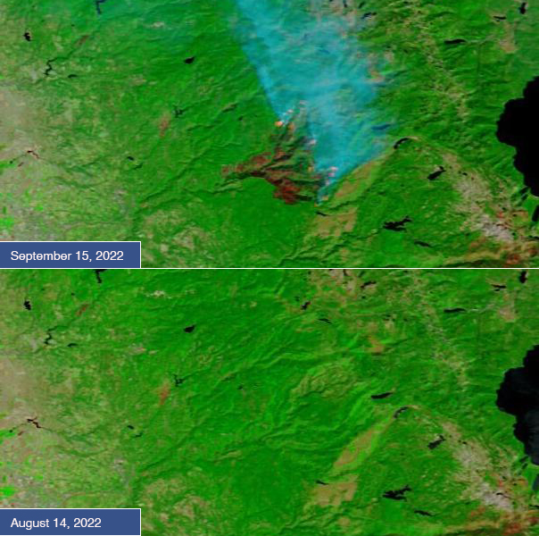
In an active wildfire season, California’s Mosquito Fire has been one of the most active blazes, becoming the largest wildfire in that state this year on September 14, 2022, when the area burned topped 63,000 acres. Since that time, the fire has continued to expand, rapidly consuming critically dry timber, brush, and grass in El Dorado and Placer counties, in between Sacramento and Lake Tahoe. It has also consumed at least 78 structures with thousands more threatened.
The Mosquito Fire was reported on the evening of September 6 about 4 miles east of Foresthill and north of Oxbow Reservoir. As of September 17, the fire has burned 71,292 acres and, with 3,453 total personnel working the blaze, has been 21 percent contained. The planned actions continue to be to provide structure defense and point protection for values at risk, protect private timberlands, scout for opportunities to construct containment lines, perform firing operations where appropriate, and construct direct and indirect line as conditions and opportunities allow. The cause of this ferocious blaze is under investigation.
Today, the Image of the Day compares two false-color images acquired of the same area by the Moderate Resolution Imaging Spectroradiometer (MODIS) on board NASA’s Terra satellite. The upper image was acquired on September 15, the day after the Mosquito Fire became the largest California wildfire of 2022, and the lower image was acquired on August 14, 2022, before the blaze had sprung to life.
In false-color images that use visible and near infrared light (MODIS bands 7,2,1), vegetation appears bright green, open land appears tan, water ranges from blue to black, smoke typically appears light blue, and burn scars may appear black, brown, or brick-red. The color variation in burn scars depends on type of vegetation burned, the completeness of the burn, the amount of residue remaining after the burn, and the age of the burn. Fresh burns are most often bright brick red, while older scars lighten and fade as vegetation returns to the burnt area, a process that takes years.
In the September 15 image, a massive burn scar is easily visualized, most of it brick red. Several actively burning areas show up as orange spots, and abundant smoke pours from the active fire “hot spots”. A small tan area to the northwest of the Mosquito Fire appears to be a burn scar from previous years, and a larger area to the southeast may also be an older burn scar, which is filing in with vegetation to give it a light tan appearance. The southeastern front of the Mosquito Fire appears to be traveling towards that area. If the fire actually reaches a burn scar, progress should be slowed in that area because fuel (vegetation) should be minimal.
In the August 14 image, the previous burn scars are visible. But the area of the Mosquito fire appears uniformly bright green, with copious vegetation.
Image Facts
Satellite:
Terra
Date Acquired: 9/15/2022
Resolutions:
1km (48 KB), 500m (104.9 KB), 250m (50.3 KB)
Bands Used: 7,2,1
Image Credit:
MODIS Land Rapid Response Team, NASA GSFC
