Images
September 30, 2022 - Winter in the Southern Alps
Tweet
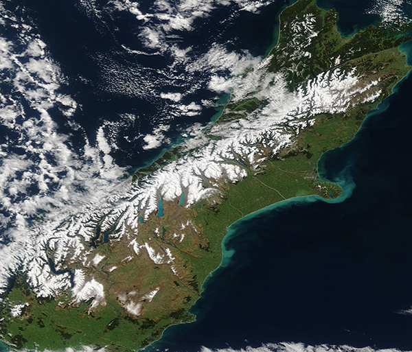
On September 15, 2022, the Moderate Resolution Imaging Spectroradiometer (MODIS) on board NASA’s Terra satellite acquired a true-color image of the northern section of New Zealand’s South Island.
The end-of-winter image showed an abundance of snow atop the rugged mountains known as the Southern Alps. Perhaps the most notable feature of South Island, these mountains extend about 400 miles (650 km) along the western side of South Island. The mountains are often obscured by clouds, which is probably why the Maoris called New Zealand "Aotearoa", the long white cloud. The higher peaks are snow-covered all year round.
According to the National Institute of Water and Atmospheric Research Ltd (NIWA), winter 2022 was the warmest on record in New Zealand, with temperatures more than 1.20˚C above average on North Island and about 0.51˚C to 1.20˚C across most of South Island. NIWA states, “Winter 2020 held the record prior to 2021 which means that New Zealand has now experienced three consecutive record-warm winters, each warmer than the year prior.” Winter 2022 was also the wettest on record since 1971, when that data began to be collected from Virtual Climate Station Network.
On South Island, where the Southern Alps hosts numerous popular ski resorts, the record-setting warm and wet conditions impacted the mountain snowpack. The first snowfall came early and heavy, dumping copious snow in June—to the delight of ski resorts, which opened early. By July, snow depth was above normal in several locations, including the deepest snowpack since 2010 in mid-July at Mt Cook Village. Unfortunately, rainy weather caused avalanches and floods in portions of the Southern Alps in late July. And warm, wet weather depleted snowpack in several locations by late August. In the closing days of winter, a heavy September snowstorm restored a blanket of white across the peaks of the Southern Alps.
Thanks to the NASA Worldview App, it's easy to compare the change in snowpack across the Southern Alps from autumn to the end of winter. To view a roll-over comparison of this Terra MODIS image, acquired on September 15, 2022, with one acquired on March 27, 2022, simply click
here
Image Facts
Satellite:
Terra
Date Acquired: 9/15/2022
Resolutions:
1km (939.2 KB), 500m (2.3 MB), 250m (1.6 MB)
Bands Used: 1,4,3
Image Credit:
MODIS Land Rapid Response Team, NASA GSFC
Tweet
On September 15, 2022, the Moderate Resolution Imaging Spectroradiometer (MODIS) on board NASA’s Terra satellite acquired a true-color image of the northern section of New Zealand’s South Island.
The end-of-winter image showed an abundance of snow atop the rugged mountains known as the Southern Alps. Perhaps the most notable feature of South Island, these mountains extend about 400 miles (650 km) along the western side of South Island. The mountains are often obscured by clouds, which is probably why the Maoris called New Zealand "Aotearoa", the long white cloud. The higher peaks are snow-covered all year round.
According to the National Institute of Water and Atmospheric Research Ltd (NIWA), winter 2022 was the warmest on record in New Zealand, with temperatures more than 1.20˚C above average on North Island and about 0.51˚C to 1.20˚C across most of South Island. NIWA states, “Winter 2020 held the record prior to 2021 which means that New Zealand has now experienced three consecutive record-warm winters, each warmer than the year prior.” Winter 2022 was also the wettest on record since 1971, when that data began to be collected from Virtual Climate Station Network.
On South Island, where the Southern Alps hosts numerous popular ski resorts, the record-setting warm and wet conditions impacted the mountain snowpack. The first snowfall came early and heavy, dumping copious snow in June—to the delight of ski resorts, which opened early. By July, snow depth was above normal in several locations, including the deepest snowpack since 2010 in mid-July at Mt Cook Village. Unfortunately, rainy weather caused avalanches and floods in portions of the Southern Alps in late July. And warm, wet weather depleted snowpack in several locations by late August. In the closing days of winter, a heavy September snowstorm restored a blanket of white across the peaks of the Southern Alps.
Thanks to the NASA Worldview App, it's easy to compare the change in snowpack across the Southern Alps from autumn to the end of winter. To view a roll-over comparison of this Terra MODIS image, acquired on September 15, 2022, with one acquired on March 27, 2022, simply click here
Image Facts
Satellite:
Terra
Date Acquired: 9/15/2022
Resolutions:
1km (939.2 KB), 500m (2.3 MB), 250m (1.6 MB)
Bands Used: 1,4,3
Image Credit:
MODIS Land Rapid Response Team, NASA GSFC


