
Images


October 21, 2022 - Flooding in the Philippines
 Tweet
Tweet
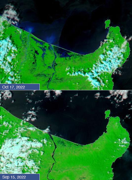
Typhoon Nesat made landfall over Calayan Island, Philippines, on October 16, 2022. Although the storm’s winds were not catastrophic, extreme rains brought heavy flooding to northern Philippines, especially the large island of Luzon and the small Calayan Island, which sits about 190 miles (306 km) north of Luzon.
Today’s Image of the Day compares two false-color images of the northeast tip of Luzon Island after the passage of Typhoon Nesat. Both images were acquired by the Moderate Resolution Imaging Spectroradiometer (MODIS) on board NASA’s Aqua satellite. The upper image was acquired on October 17, as skies were beginning to clear. Much of the northern coast was completely under water, and flood water (which appears blue) is present more than 20 miles inland. The Cagayan River had overflowed its banks, creating additional flooding near the river’s course. The lower image was acquired on September 15, a month before Nesat’s passage, showing a much different scene. The comparison between the two dates is stark.
According to Agroinsurance, on October 19 damage to agriculture in the Philippines from Nesat was estimated at 366,058,240 Philippine pesos. This is equivalent to about $6,214,383 US dollars. It is also estimated that 14,578 farmers had been affected, with over 19,000 hectares of crops damaged. Cagayan Valley suffered the greatest agricultural loss.
Image Facts
Satellite:
Aqua
Date Acquired: 10/17/2022
Resolutions:
1km (113.1 KB), 500m (266.1 KB), 250m (151.8 KB)
Bands Used: 1,4,3
Image Credit:
MODIS Land Rapid Response Team, NASA GSFC
