
Images


November 16, 2022 - Life-threatening Flooding along Barwon and Darling Rivers, Australia
 Tweet
Tweet
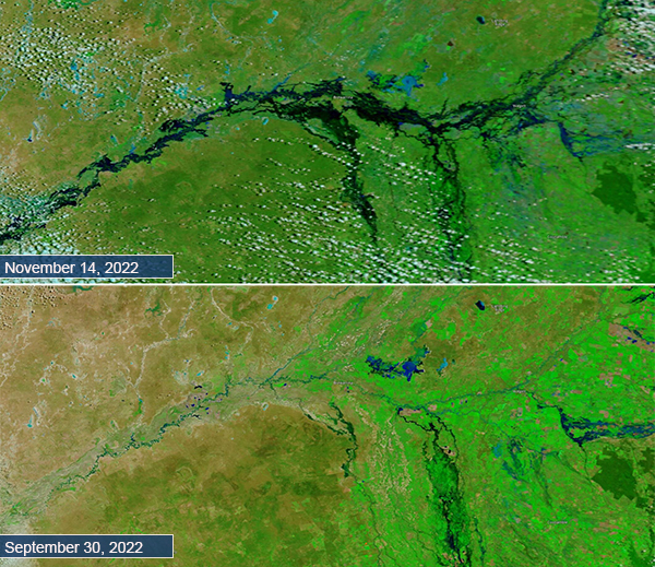
Waves of heavy rainfall left vast areas of eastern Australia under water in October and November 2022. By mid-November, swollen rivers flooded landscapes from southern Queensland and New South Wales to northern Victoria. The inundation has damaged cropland, homes, and even taken lives. On November 1, ReliefWeb reported that two people had been reported missing after their car was swept away by floodwaters in Boorowa, New South Wales. Also, from November 2-3, authorities in New South Wales responded to 345 requests for assistance, with 14 flood rescues. At that time, additional rain was anticipated over the region.
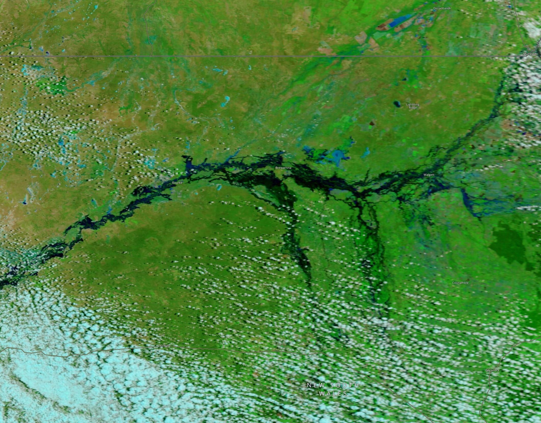
On November 14, the Moderate Resolution Imaging Spectroradiometer (MODIS) on board NASA’s Terra satellite acquired a false-color image of flooding along the Barwon and Darling rivers in New South Wales and close to the border in Queensland. Queensland sits along the northern edge of the image. Water appears light to dark blue. Vegetation is green and bare land is brown. For comparison, the Terra MODIS image acquired on September 30, after rains had begun to fall but before flooding had become severe, sits beneath the November image.
On November 14, ABC News in Australia reported “Emergency services in New South Wales are facing the largest flood operation in the state's history as more defence force personnel and volunteers from around the world join rescue and relief efforts. Hundreds more homes are expected to go under this week and more than 1,000 people have been evacuated as flood levels rose faster than expected overnight…”. They report more than 200 people had been rescued from floodwater in the past 24 hours and State Emergency Service had received more than 900 calls for help in that time. Volunteer assistance is coming from New Zealand, Singapore, and the United States.
Image Facts
Satellite:
Terra
Date Acquired: 11/14/2022
Resolutions:
1km (372.9 KB), 500m (892.5 KB), 250m (526.9 KB)
Bands Used: 7.2.1
Image Credit:
MODIS Land Rapid Response Team, NASA GSFC
Waves of heavy rainfall left vast areas of eastern Australia under water in October and November 2022. By mid-November, swollen rivers flooded landscapes from southern Queensland and New South Wales to northern Victoria. The inundation has damaged cropland, homes, and even taken lives. On November 1, ReliefWeb reported that two people had been reported missing after their car was swept away by floodwaters in Boorowa, New South Wales. Also, from November 2-3, authorities in New South Wales responded to 345 requests for assistance, with 14 flood rescues. At that time, additional rain was anticipated over the region.
On November 14, the Moderate Resolution Imaging Spectroradiometer (MODIS) on board NASA’s Terra satellite acquired a false-color image of flooding along the Barwon and Darling rivers in New South Wales and close to the border in Queensland. Queensland sits along the northern edge of the image. Water appears light to dark blue. Vegetation is green and bare land is brown. For comparison, the Terra MODIS image acquired on September 30, after rains had begun to fall but before flooding had become severe, sits beneath the November image.
On November 14, ABC News in Australia reported “Emergency services in New South Wales are facing the largest flood operation in the state's history as more defence force personnel and volunteers from around the world join rescue and relief efforts. Hundreds more homes are expected to go under this week and more than 1,000 people have been evacuated as flood levels rose faster than expected overnight…”. They report more than 200 people had been rescued from floodwater in the past 24 hours and State Emergency Service had received more than 900 calls for help in that time. Volunteer assistance is coming from New Zealand, Singapore, and the United States.
Image Facts
Satellite:
Terra
Date Acquired: 11/14/2022
Resolutions:
1km (372.9 KB), 500m (892.5 KB), 250m (526.9 KB)
Bands Used: 7.2.1
Image Credit:
MODIS Land Rapid Response Team, NASA GSFC
