
Images


November 23, 2022 - Heavy Lake-Effect Snow in Western New York
 Tweet
Tweet
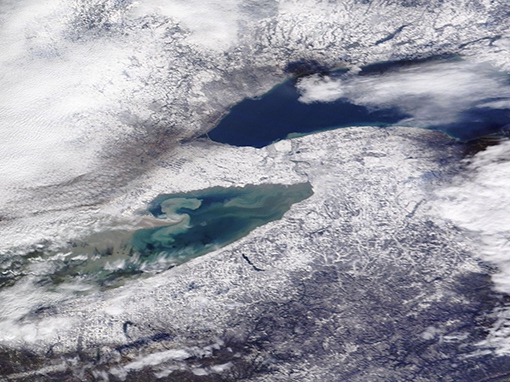
In mid-November 2022, frigid air swept across Lake Erie and Lake Ontario, triggering a long-duration lake effect snow event that dropped record snowfall in parts of western New York. The first snowflakes fell on November 16, with formation of high-intensity bands of snow following soon after.
On November 19, the Buffalo Airport reported a record snowfall of 17.2 inches for that date—handily beating the previous record of 7.6 inches which fell on the same date in 2014. By that time, Orchard Park, south of Buffalo, was shivering under a monumental 77 inches of fresh snow. The snow came with a price, snarling traffic and dropping visibility to less than a half-mile at times. Media reported at least two deaths due to the storm and more than 200 people requiring emergency service response or rescue.
On November 21, as falling flakes began to disappear and the skies to clear, the National Weather Service tabulated totals for the storm while residents living in the heaviest bands continued to dig out. The town of Hamburg, just south of Buffalo, won the prize for the deepest snow, measuring-in at 81 inches. Nearby Orchard Park was next in line, with a storm total of 80 inches. Meanwhile, Tonawanda, a northern suburb of Buffalo, registered a relatively-sparse 12.1 inches. Such wide differences in snow accumulation are common in lake-effect snow, due to the formation of snow bands that can be relatively narrow.
The Moderate Resolution Imaging Spectroradiometer (MODIS) on board NASA’s Terra satellite acquired a true-color image of the aftermath of the snowstorm on November 21 as skies began to clear. Clouds remain heavy in the west and over Lake Ontario while sediment swirls in Lake Erie. Snow accumulation is heaviest in a ring around Lake Erie, especially in the northeast.
Lake-effect snow occurs along the eastern edge of the Great Lakes when icy wind blows across the lakes from Canada. The wind picks up relatively warm, moist air over the lakes and pushes it over land, where the air is cooler. When the moist air encounters cooler temperatures over land, the water condenses into precipitation, which in cold temperatures falls as snow.
Image Facts
Satellite:
Terra
Date Acquired: 11/21/2022
Resolutions:
1km (214.2 KB), 500m (571.6 KB), 250m (386.5 KB)
Bands Used: 1,4,3
Image Credit:
MODIS Land Rapid Response Team, NASA GSFC
