
Images


December 11, 2022 - Snow in the Western United States
 Tweet
Tweet
Snow continued to create a wintery scene across much of the Western United States through early December 2022. On December 8, the National Weather Service National Snow Analysis maps showed more than 40 inches of snow had already accumulated across most of the high ranges of the Rocky Mountains, Sierra Nevada, and Cascades. The Utah Avalanche Center reported 50 avalanches in the state from December 1 through December 10, with 40 of those occurring before December 10. Many of the reported avalanches were located in the Wasatch Mountains southeast of Salt Lake City and near Park City. Across most of the Utah mountains, avalanche risk remained “Considerable” on December 10. According to local news media, as of December 8 the Utah statewide snowpack contained 4.6 inches of water, which was 157% of normal for this point in the season, and the current snowpack was nearly six times higher than the same time in the previous year.
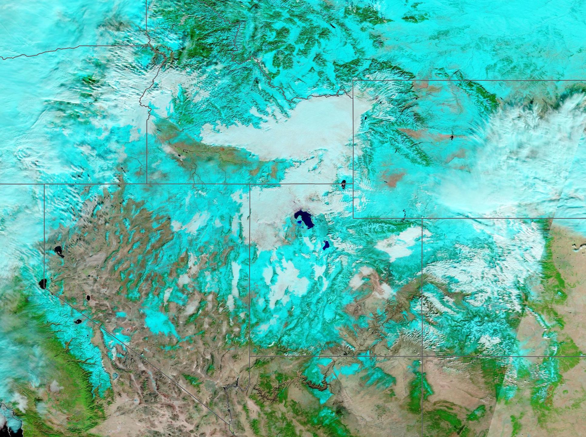
On December 8, the Moderate Resolution Imaging Spectroradiometer (MODIS) on board NASA’s Terra satellite acquired a false-color image of snow and cloud in in the Western United States. This type of false-color image helps separate snow from cloud. Both appear white in true-color images, but here snow looks electric blue while cloud remains white. In addition, vegetation looks green, open land is tan or brown, and water is deep blue.
The Great Salt Lake, Utah is located near the center of this image. Starting from the north and moving clockwise around Utah, other states seen in this image include Idaho, Montana, Wyoming, Colorado, New Mexico, Arizona, California, Nevada, and Oregon. Snow is widespread in most of the mountain ranges, but patches of snow also sit in lower elevations, particularly in Colorado. Cloud, possibly bringing additional snow, is also widespread.
Another major snowstorm is expected to begin in the Western United States and roll eastward from December 11 through 13. According to the National Weather Service, the storm will start across the Pacific Northwest, Northern Rockies, Great Basin, and California, with snowfall totals through the weekend generally ranging between 12-24 inches, locally higher, for higher elevations in the mountains. The heaviest snowfall is expected for the Sierra Nevada. Extreme snowfall could occur in the Sierra and northern California, including snowfall rates of three inches per hour. Some forecasts are predicting more than five feet of snow in parts of the Sierra Nevada by December 11 before the storm pushes eastward.
Image Facts
Satellite:
Terra
Date Acquired: 12/8/2022
Resolutions:
1km (590.7 KB), 500m (827.5 KB), 250m (6.7 MB)
Bands Used: 7,2,1
Image Credit:
MODIS Land Rapid Response Team, NASA GSFC
Snow continued to create a wintery scene across much of the Western United States through early December 2022. On December 8, the National Weather Service National Snow Analysis maps showed more than 40 inches of snow had already accumulated across most of the high ranges of the Rocky Mountains, Sierra Nevada, and Cascades. The Utah Avalanche Center reported 50 avalanches in the state from December 1 through December 10, with 40 of those occurring before December 10. Many of the reported avalanches were located in the Wasatch Mountains southeast of Salt Lake City and near Park City. Across most of the Utah mountains, avalanche risk remained “Considerable” on December 10. According to local news media, as of December 8 the Utah statewide snowpack contained 4.6 inches of water, which was 157% of normal for this point in the season, and the current snowpack was nearly six times higher than the same time in the previous year.
On December 8, the Moderate Resolution Imaging Spectroradiometer (MODIS) on board NASA’s Terra satellite acquired a false-color image of snow and cloud in in the Western United States. This type of false-color image helps separate snow from cloud. Both appear white in true-color images, but here snow looks electric blue while cloud remains white. In addition, vegetation looks green, open land is tan or brown, and water is deep blue.
The Great Salt Lake, Utah is located near the center of this image. Starting from the north and moving clockwise around Utah, other states seen in this image include Idaho, Montana, Wyoming, Colorado, New Mexico, Arizona, California, Nevada, and Oregon. Snow is widespread in most of the mountain ranges, but patches of snow also sit in lower elevations, particularly in Colorado. Cloud, possibly bringing additional snow, is also widespread.
Another major snowstorm is expected to begin in the Western United States and roll eastward from December 11 through 13. According to the National Weather Service, the storm will start across the Pacific Northwest, Northern Rockies, Great Basin, and California, with snowfall totals through the weekend generally ranging between 12-24 inches, locally higher, for higher elevations in the mountains. The heaviest snowfall is expected for the Sierra Nevada. Extreme snowfall could occur in the Sierra and northern California, including snowfall rates of three inches per hour. Some forecasts are predicting more than five feet of snow in parts of the Sierra Nevada by December 11 before the storm pushes eastward.
Image Facts
Satellite:
Terra
Date Acquired: 12/8/2022
Resolutions:
1km (590.7 KB), 500m (827.5 KB), 250m (6.7 MB)
Bands Used: 7,2,1
Image Credit:
MODIS Land Rapid Response Team, NASA GSFC
