
Images


February 20, 2023 - Gulf of Khambhat
 Tweet
Tweet
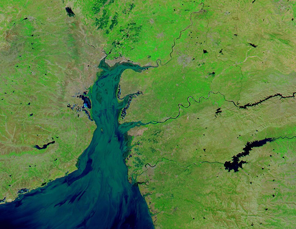
The Gulf of Khambhat is a trumpet-shaped extension of the Arabian Sea, lying on the west coast of India between the Saurashtra Peninsula and mainland Gujarat. At the northern end, the Gulf is only about 15 miles (24 km) wide, but it expands to about 120 miles (190 km) at the widest point in the south.
Several major river systems—including the Narmada, Tapi, Mahi, Sabarmati, and Shetrunji—deliver abundant freshwater and heavy sediment loads to the gulf. The gulf measures 80 kilometers (50 miles) wide at its mouth in the Arabian Sea but narrows to about 25 kilometers (15 miles) at its head, where the deltas of the Sabarmati and Mahi rivers meet.
On February 12, 2023, the Moderate Resolution Imaging Spectroradiometer (MODIS) on board NASA’s Aqua satellite acquired a false-color image of the Gulf of Khambhat.
In this type of image, vegetation is bright green, open land is tan, water appears blue or inky black with deeper water looking darker. Suspended sediment, which can be seen entering the Gulf from many of the rivers, appears dull green near the surface but takes on blue tones as it sinks and disperses. A bright electric blue area along the western coast of the Gulf are crusts of minerals on salt ponds near Bhavnagar, Gujarat. With more than 50 percent of salt workers located in Gujarat, the state accounts for almost three-quarters of the country's annual salt production.
Image Facts
Satellite:
Aqua
Date Acquired: 2/12/2023
Resolutions:
500m (355.6 KB), 250m (199.1 KB)
Bands Used: 7,2,1
Image Credit:
MODIS Land Rapid Response Team, NASA GSFC
