Images
February 22, 2023 - Tropical Cyclone Freddy Slams Madagascar
Tweet
After traveling for 15 days across the Indian Ocean, Tropical Cyclone Freddy made landfall on the east coast of Madagascar on the evening of February 21, 2023.
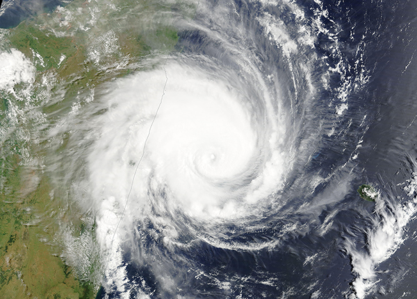
The Moderate Resolution Imaging Spectroradiometer (MODIS) on board NASA’s Terra satellite acquired a true-color image of Freddy roaring toward Madagascar hours before landfall on February 21. Near the time the image was acquired, maximum sustained winds were estimated at 120 mph (193 km/h) or the equivalent of a Category 3 storm on the Saffir-Simpson Hurricane Wind Scale.
Fortunately, Tropical Cyclone Freddy was rapidly losing power. As Freddy made landfall north of Mananjary around 7:20 p.m. local time, it had weakened to Category 1 strength, with winds estimated at about 80 mph (130 km/h), although precise windspeeds at landfall were yet to be confirmed. The coastal town of Mananjary, home to 25,000 people, was previously hit hard in February 2022 by the deadly Cyclone Batsirai.
Forecasts called for Freddy to bring damaging winds, storm surge, and heavy rains as the storm moves inland. Rainfall may be especially damaging in places still recovering from Cyclone Cheneso, which killed dozens of people and left thousands homeless in the island nation in January 2023.
Since forming near Indonesia on February 6, Freddy has traveled about 7,200 kilometers across the Indian Ocean, according to the UK Met Office. The 15-day lifespan of the cyclone is unusual; few cyclones travel so far and are sustained for so long. The longest-lived tropical cyclone in the southern hemisphere was Leon-Eline in 2000, which was sustained for 18.5 days and traveled a similar path to Freddy.
Freddy was forecasted to continue moving westward and cross into the Mozambique Channel before strengthening and landing on Mozambique later in the week. Freddy was the second cyclone to hit Madagascar during the 2022–2023 season, which runs from around late October to May in the southwest Indian Ocean.
Image Facts
Satellite:
Terra
Date Acquired: 2/21/2023
Resolutions:
1km (1.1 MB), 500m (3 MB), 250m (2.1 MB)
Bands Used: 1,4,3
Image Credit:
MODIS Land Rapid Response Team, NASA GSFC
Tweet
After traveling for 15 days across the Indian Ocean, Tropical Cyclone Freddy made landfall on the east coast of Madagascar on the evening of February 21, 2023.
The Moderate Resolution Imaging Spectroradiometer (MODIS) on board NASA’s Terra satellite acquired a true-color image of Freddy roaring toward Madagascar hours before landfall on February 21. Near the time the image was acquired, maximum sustained winds were estimated at 120 mph (193 km/h) or the equivalent of a Category 3 storm on the Saffir-Simpson Hurricane Wind Scale.
Fortunately, Tropical Cyclone Freddy was rapidly losing power. As Freddy made landfall north of Mananjary around 7:20 p.m. local time, it had weakened to Category 1 strength, with winds estimated at about 80 mph (130 km/h), although precise windspeeds at landfall were yet to be confirmed. The coastal town of Mananjary, home to 25,000 people, was previously hit hard in February 2022 by the deadly Cyclone Batsirai.
Forecasts called for Freddy to bring damaging winds, storm surge, and heavy rains as the storm moves inland. Rainfall may be especially damaging in places still recovering from Cyclone Cheneso, which killed dozens of people and left thousands homeless in the island nation in January 2023. Since forming near Indonesia on February 6, Freddy has traveled about 7,200 kilometers across the Indian Ocean, according to the UK Met Office. The 15-day lifespan of the cyclone is unusual; few cyclones travel so far and are sustained for so long. The longest-lived tropical cyclone in the southern hemisphere was Leon-Eline in 2000, which was sustained for 18.5 days and traveled a similar path to Freddy.
Freddy was forecasted to continue moving westward and cross into the Mozambique Channel before strengthening and landing on Mozambique later in the week. Freddy was the second cyclone to hit Madagascar during the 2022–2023 season, which runs from around late October to May in the southwest Indian Ocean.
Image Facts
Satellite:
Terra
Date Acquired: 2/21/2023
Resolutions:
1km (1.1 MB), 500m (3 MB), 250m (2.1 MB)
Bands Used: 1,4,3
Image Credit:
MODIS Land Rapid Response Team, NASA GSFC


