
Images


March 17, 2023 - Flooded Lake Tarabool, Northern Territory, Australia
 Tweet
Tweet
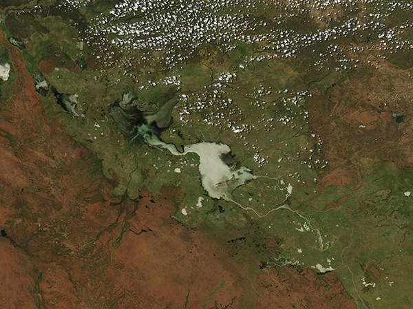
A passing tropical low dumped several days of downpours on Australia’s Northern Territory in early March 2023. The widespread downpours pushed rivers beyond their banks and forced evacuations from several communities.
On March 16, 2023, the Moderate Resolution Imaging Spectroradiometer (MODIS) on board NASA’s Aqua satellite acquired a true-color image of flooded Lake Tarabool and the Eva Downs Swamp in northeastern Northern Territory. For most of the year, Tarabool is a small body of water, but when inundated due to seasonal or exceptional rainfall, the lake expands into the surrounding swamp, creating a massive freshwater wetland spanning 275,000 hectares. Water is slow to recede and may remain for more than a year after heavy inundation.
Lake Tarabool and Eva Downs Swamp are listed on the Register of the National Estate and the Directory of Important Wetlands in Australia and are classified as sites of conservation significance by the Northern Territory Government. The area is listed as an Important Bird Area (IBA) by BirdLife International, with more than 250,000 birds counted at one time in a recent inundation. The land is private, however, and has not been formally conserved.
According to news reports, the mid-March floods swamped cattle pastures, roads, and homes in the remote region near Tarabool in Northern Territory. Farther north and west in the more densely populated Victoria Daly and Roper Gulf regions, floodwaters inundated entire towns, blocked key roads and rail lines, and disrupted food supplies. Daguragu, Kalkarindji, Pigeon Hole, and Palumpa are among the towns that had to be evacuated.
While this single image shows a well-filled lake surrounded by widespread water, the best way to appreciate the extent of this year’s flooding is to compare with a similar image acquired on a more normal March day. Thanks to the NASA Worldview app, this can be done simply by clicking here, which reveals a roll-over image comparing the March 16, 2023 view of the inundated lake with another Aqua MODIS image acquired on March 5, 2022, on a more typical year.
Image Facts
Satellite:
Aqua
Date Acquired: 3/16/2023
Resolutions:
1km (208.8 KB), 500m (550.6 KB), 250m (382.3 KB)
Bands Used: 1,4,3
Image Credit:
MODIS Land Rapid Response Team, NASA GSFC
