
Images


October 11, 2023 - Hurricane Lidia and Tropical Storm Max Swamp Western Mexico
 Tweet
Tweet
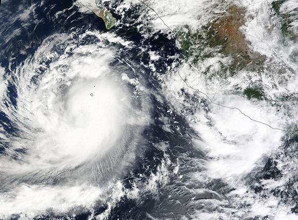
Near 2:00 p.m. EDT on October 9, 2023, the Moderate Resolution Imaging Spectroradiometer (MODIS) on NASA’s Terra satellite captured a true-color image of two tropical systems charging the coast of western Mexico. At that time, compact Tropical Storm Max was making landfall in southwestern Mexico while Lidia, still a tropical storm with 70 mph (112.7 km/h) maximum sustained winds, had just begun rapid intensification.
Only 30 hours later, Hurricane Lidia made landfall in west-central Mexico as an extremely dangerous Category 4 Hurricane with maximum sustained winds of 140 mph (225 km/h). According to the National Hurricane Center (NHC), Lidia made landfall near 8:00 p.m. EDT on October 10 about 15 miles (25 km) south-southeast of Cabo Corrientes and about 35 miles (55 km) south-southwest of Puerto Vallarta, Mexico. It was carrying “life-threatening winds and flooding rainfall spreading inland”. Social media posts shortly after landfall suggest widespread power outages, rising surf, and damage to some buildings in Puerto Vallarta.
According to the NHC, Tropical Storm Max made landfall near 2:00 p.m. EDT on October 9 about 30 miles (50 km) southeast of Zihuatanejo, Mexico with maximum sustained winds of 60 mph (95 km/h). Mexico News Daily reported two deaths had been attributed to the storm, both in the coastal municipality of Técpan de Galeana, located southeast of Zihuatanejo. Widespread flooding of both homes and highways near the track of Tropical Storm Max has also been reported.
Image Facts
Satellite:
Terra
Date Acquired: 10/9/2023
Resolutions:
1km (535.4 KB), 500m (1.7 MB), 250m (1.7 MB)
Bands Used: 1,4,3
Image Credit:
MODIS Land Rapid Response Team, NASA GSFC
