
Images


November 24, 2023 - Sediment Swirls around Hainan Island
 Tweet
Tweet
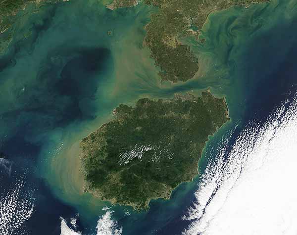
Colorful swirls and eddies tinted the waters off China’s Leizhou Peninsula and Hainan Island in mid-November 2023. The Moderate Resolution Imaging Spectroradiometer (MODIS) on NASA’s Terra satellite captured the jewel-and-mud-like tones on November 17.
The Leizhou Peninsula is a landform that juts out into the South China Sea from the southernmost portion of mainland China. The Gulf of Tonkin (Beibu Gulf) lies to the west, and the Qiongzhou Strait (Hainan Strait) passes to the south.
Hainan Island is China’s southernmost province, spanning approximately 339,000 hectares (1,300 square miles). It sits at the northern edge of the tropics and is dominated by a tropical monsoon climate, with an annual mean rainfall of about 1,500 mm (59 inches). Most of the rain occurs between May and October.
The colors dancing in the waters surrounding both the Peninsula and the Island appears to be primarily sediment, which takes on a muddy tan tint as it floats near the surface but looks green and then blue as it sinks deeper under the surface. The green tones may indicate that an abundance of microscopic plant-like organisms called phytoplankton are present along with sediment. The paintbrush-like appearance of the water is created by currents and tides, which stir sediment and mix it into colorful designs.
Image Facts
Satellite:
Terra
Date Acquired: 11/17/2023
Resolutions:
1km (41.6 KB), 500m (99.4 KB), 250m (203.5 KB)
Bands Used: 1,4,3
Image Credit:
MODIS Land Rapid Response Team, NASA GSFC
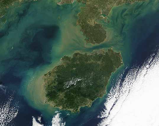
