
Images


December 3, 2023 - Flooding along the Shabelle River, Somalia

November 30, 2023
December 13, 2022
Tweet
After five consecutive seasons of severe drought, followed by flooding in May 2023, many farmers in Somalia were forced to abandon their land. By September, as planting time approached, the Food and Agriculture Organization of the United Nations (FAO) began to distribute seed (maize, mung bean, cowpea, and vegetable) and farm tools to support farmers who remained in or returned to the most food-insecure regions.
Then the rains came. Torrential rains. A “Once-in-a-century event”, according to the United Nations.
In October, the federal government of Somalia declared a state of emergency after widespread floods destroyed homes, roads, and bridges and turning recently parched soil into wetlands. And the rains have continued to pour.
By November 16, ReliefWeb reported that floods had killed at least 111 people—including 16 children—with more than 770,000 people displaced. The humanitarian organization Save the Children also reported that the central Somalia town of Beledweyne was completely submerged after the Shabelle River burst its banks forcing an estimated 250,000 people out of their homes. In addition, any crops planted in the flooded land have been almost entirely destroyed.
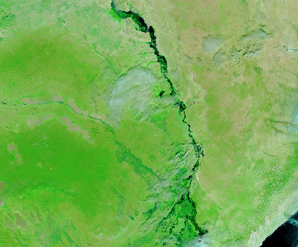
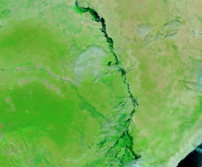
On November 30, 2023, the Moderate Resolution Imaging Spectroradiometer (MODIS) on NASA’s Terra satellite acquired a true-color image centered on the Shabelle River in Southern Somalia. In this type of image, water appears blue or black (deeper water is darker), vegetation is bright green, open/sparsely vegetated land looks tan, and cloud may appear white or tinted light blue. The town of Beledweyne sits on the Shabelle River near the border with Ethiopia. In this image, it is located underneath the deepest water in the north.
To compare with a second Terra MODIS false-color image of the same area acquired on December 13, 2022, simply click on the date below the image. At this time, the region was in drought and the Shabelle River is barely visible. Most of the green, especially by the riverbanks, are most likely crops from small farms.
Image Facts
Satellite:
Terra
Date Acquired: 11/30/2023
Resolutions:
1km (135.1 KB), 500m (318.2 KB), 250m (183.3 KB)
Bands Used: 1,4,3
Image Credit:
MODIS Land Rapid Response Team, NASA GSFC
November 30, 2023 December 13, 2022
After five consecutive seasons of severe drought, followed by flooding in May 2023, many farmers in Somalia were forced to abandon their land. By September, as planting time approached, the Food and Agriculture Organization of the United Nations (FAO) began to distribute seed (maize, mung bean, cowpea, and vegetable) and farm tools to support farmers who remained in or returned to the most food-insecure regions.
Then the rains came. Torrential rains. A “Once-in-a-century event”, according to the United Nations.
In October, the federal government of Somalia declared a state of emergency after widespread floods destroyed homes, roads, and bridges and turning recently parched soil into wetlands. And the rains have continued to pour.
By November 16, ReliefWeb reported that floods had killed at least 111 people—including 16 children—with more than 770,000 people displaced. The humanitarian organization Save the Children also reported that the central Somalia town of Beledweyne was completely submerged after the Shabelle River burst its banks forcing an estimated 250,000 people out of their homes. In addition, any crops planted in the flooded land have been almost entirely destroyed.
On November 30, 2023, the Moderate Resolution Imaging Spectroradiometer (MODIS) on NASA’s Terra satellite acquired a true-color image centered on the Shabelle River in Southern Somalia. In this type of image, water appears blue or black (deeper water is darker), vegetation is bright green, open/sparsely vegetated land looks tan, and cloud may appear white or tinted light blue. The town of Beledweyne sits on the Shabelle River near the border with Ethiopia. In this image, it is located underneath the deepest water in the north.
To compare with a second Terra MODIS false-color image of the same area acquired on December 13, 2022, simply click on the date below the image. At this time, the region was in drought and the Shabelle River is barely visible. Most of the green, especially by the riverbanks, are most likely crops from small farms.
Image Facts
Satellite:
Terra
Date Acquired: 11/30/2023
Resolutions:
1km (135.1 KB), 500m (318.2 KB), 250m (183.3 KB)
Bands Used: 1,4,3
Image Credit:
MODIS Land Rapid Response Team, NASA GSFC
