
Images


December 5, 2023 - Tropical Cyclone Michaung
 Tweet
Tweet
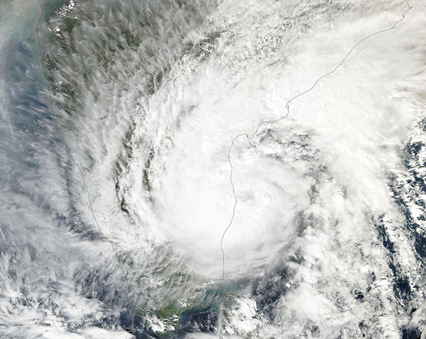
A short-lived tropical cyclone formed in the Bay of Bengal on December 3, 2023. Later that day, the Moderate Resolution Imaging Spectroradiometer (MODIS) on NASA’s Aqua satellite acquired a true-color image of Tropical Cyclone Michaung as it approached landfall on India’s coast. At the time the image was captured, the storm was bringing drenching rain across much of southeastern India while maximum sustained winds were estimated at about 70 mph (112.6 km/h), which placed it at tropical storm strength.
Tropical Cyclone Michaung made landfall over the Nellore District of the state of Andhra Pradesh early in the morning of December 5. It rapidly weakened as it moved northwestward over land. At 2:30 am India Standard Time on December 5 (4:00 p.m. EST on December 4), the Joint Typhoon Warning Center issued its final warning on the storm. At that time, the center of the rapidly dissipating system was located about 137 km (85 miles) north of Chennai, in Tamil Nadu State. Maximum sustained winds were estimated near 57 mph (92 km/h).
As Tropical Cyclone Michaung approached the coast, government authorities set up 4,967 aid camps and 121 safe shelters, and 13 teams from the National Disaster Response Force were pre-placed to assist, according to ReliefWeb. Media reports stated that low-lying areas near Chennai, the capital of Tamil Nadu, were inundated prior to Michaung’s landfall. Intense rains and strong winds toppled trees and caused walls to collapse. Chennai airport was forced to close due to flooding. At least six people have been reported to have died in the storm.
Image Facts
Satellite:
Aqua
Date Acquired: 12/4/2023
Resolutions:
1km (349.1 KB), 500m (1 MB), 250m (2.9 MB)
Bands Used: 1,4,3
Image Credit:
MODIS Land Rapid Response Team, NASA GSFC
