
Images


January 8, 2024 - Snow in South Dakota and Nebraska
 Tweet
Tweet
A strong winter storm brought wind, snow, and ice to the Northern and Central Plains of the United States between December 25 and 27, 2024. North Dakota and northeastern South Dakota felt the brunt of the Christmas Day ice storm, while high winds brought blizzard conditions and significant snowfall in South Dakota and Nebraska.
The National Weather Service (NWS) reported that the highest ice accumulations were Verona and Edgeley, North Dakota, where 1 inch of ice was measured on December 26. The town of Oakes, located in southern North Dakota, reported wind gusts of 67 mph on December 25. The NWS also described the impact of the powerful low-pressure system on South Dakota (SD), “Plentiful moisture wrapped around the low into western SD, bringing heavy snow to parts of our area. The highest amounts were in the northern Black Hills, where over a foot of snow fell. A tight pressure gradient resulted in very strong winds on the western SD plains, with gusts of 50-60 mph creating blizzard conditions with much blowing and drifting snow. The highest wind gust was 72 mph at the Rapid City Airport. As warm air filtered into the region below the low, snow changed to freezing rain, which caused some icing across parts of northwestern SD. Much of Interstate 90 was closed for about 12 hours, and even afterwards, no travel was advised, especially in the northern Black Hills.”
The NWS National Gridded Snowfall Analysis (72 hours preceding December 27) showed that parts of South Dakota received between 18 and 24 inches from the storm, while most of the state and northern Nebraska accumulated up to 12 inches.
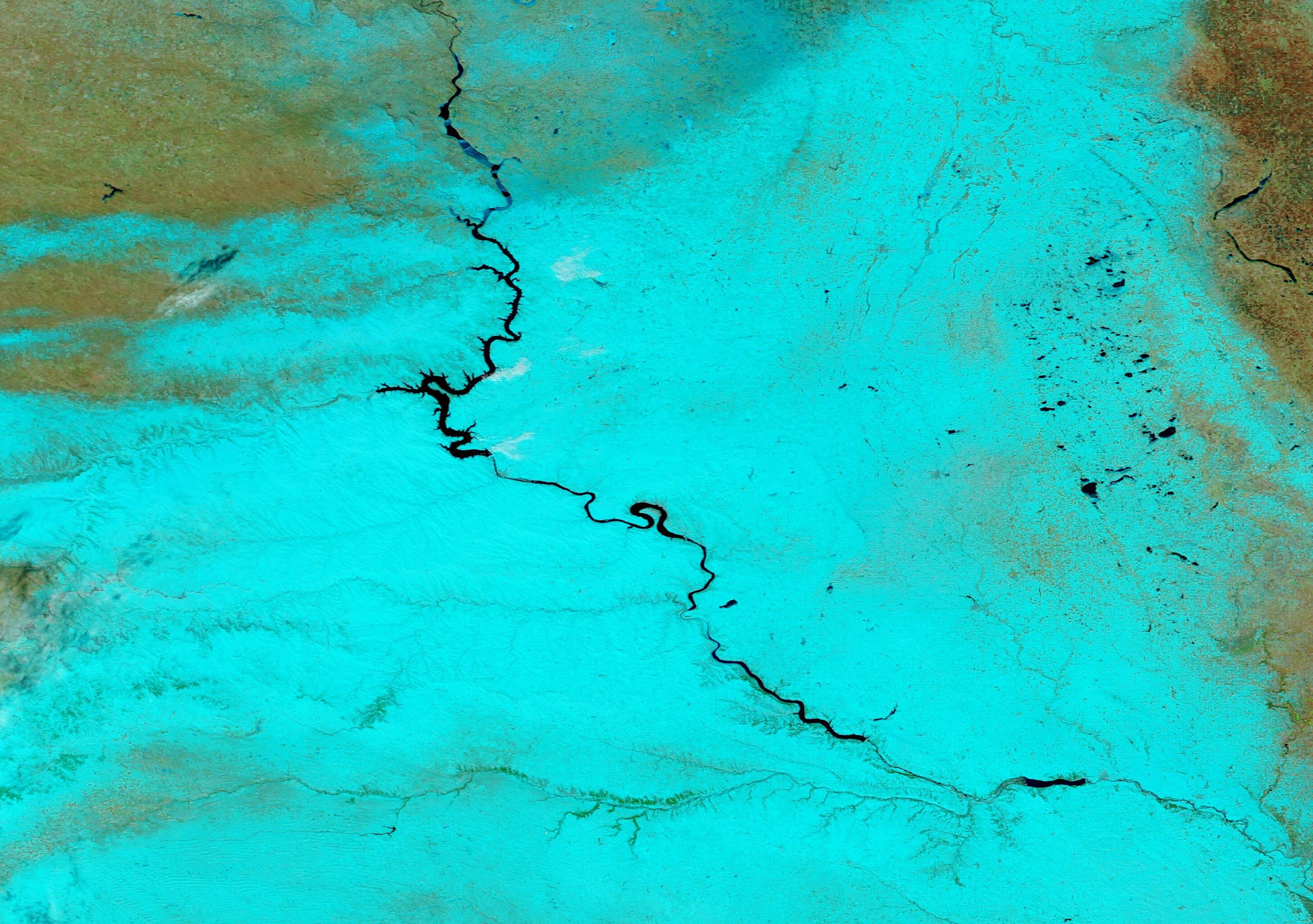
The heavy accumulation lingered across the Central Plains through January 1, 2024, when the Moderate Resolution Imaging Spectroradiometer (MODIS) on NASA’s Aqua satellite acquired a false-color image centered on South Dakota. In this type of image, snow looks bright blue, vegetation is green, open land looks tan, while water appears blue. The Missouri River, which remains free of ice, courses through South Dakota and, in the south, crosses into Nebraska.
Image Facts
Satellite:
Aqua
Date Acquired: 1/1/2024
Resolutions:
1km (258.2 KB), 500m (618.3 KB), 250m (846.3 KB)
Bands Used: 7,2,1
Image Credit:
MODIS Land Rapid Response Team, NASA GSFC
A strong winter storm brought wind, snow, and ice to the Northern and Central Plains of the United States between December 25 and 27, 2024. North Dakota and northeastern South Dakota felt the brunt of the Christmas Day ice storm, while high winds brought blizzard conditions and significant snowfall in South Dakota and Nebraska.
The National Weather Service (NWS) reported that the highest ice accumulations were Verona and Edgeley, North Dakota, where 1 inch of ice was measured on December 26. The town of Oakes, located in southern North Dakota, reported wind gusts of 67 mph on December 25. The NWS also described the impact of the powerful low-pressure system on South Dakota (SD), “Plentiful moisture wrapped around the low into western SD, bringing heavy snow to parts of our area. The highest amounts were in the northern Black Hills, where over a foot of snow fell. A tight pressure gradient resulted in very strong winds on the western SD plains, with gusts of 50-60 mph creating blizzard conditions with much blowing and drifting snow. The highest wind gust was 72 mph at the Rapid City Airport. As warm air filtered into the region below the low, snow changed to freezing rain, which caused some icing across parts of northwestern SD. Much of Interstate 90 was closed for about 12 hours, and even afterwards, no travel was advised, especially in the northern Black Hills.”
The NWS National Gridded Snowfall Analysis (72 hours preceding December 27) showed that parts of South Dakota received between 18 and 24 inches from the storm, while most of the state and northern Nebraska accumulated up to 12 inches.
The heavy accumulation lingered across the Central Plains through January 1, 2024, when the Moderate Resolution Imaging Spectroradiometer (MODIS) on NASA’s Aqua satellite acquired a false-color image centered on South Dakota. In this type of image, snow looks bright blue, vegetation is green, open land looks tan, while water appears blue. The Missouri River, which remains free of ice, courses through South Dakota and, in the south, crosses into Nebraska.
Image Facts
Satellite:
Aqua
Date Acquired: 1/1/2024
Resolutions:
1km (258.2 KB), 500m (618.3 KB), 250m (846.3 KB)
Bands Used: 7,2,1
Image Credit:
MODIS Land Rapid Response Team, NASA GSFC
