Images
February 6, 2024 - Another Atmospheric River Batters California
Tweet
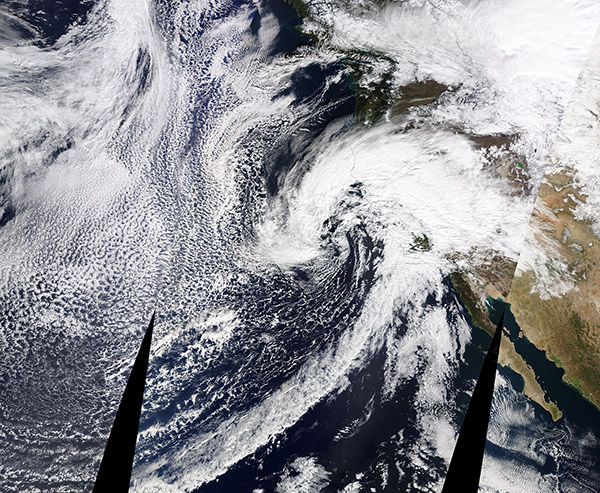
On February 4, 2024, the Moderate Resolution Imaging Spectroradiometer (MODIS) on NASA’s Terra satellite acquired a true-color image of an especially vicious atmospheric river beginning to strike the West Coast of the United States.
By February 5, the storm had killed at least 3 people in Northern California and dropped enough snow in Nevada to trigger an avalanche. The deaths were attributed to trees falling due to the storm, according to media reports. Meanwhile, record-setting rains in Southern California tested the emergency responders’ swift water rescue skills as streams turned into raging rapids, threatening to sweep cars, debris, and sometimes people and pets away. In just one locality—Riverside, California—fire officials were quoted as reporting that 10 people and 17 dogs were rescued between 10 a.m. and 2 p.m. on February 5.
According to the National Weather Service, parts of Los Angeles County had received more than 10 inches (25.4 cm) in 48 hours—more than the average amount expected for the entire month of February. The February average in downtown Los Angeles is 3.80 inches (9.6 cm), but rainfall in the 24 hours between 8:00 am February 4 and 8:00 a.m. February 5 was measured at 5.62 inches (14.3 cm).
The system will continue to bring rain to Southern California through February 6, but is forecast to move slowly eastward over the upcoming week. It is forecast to drop heavy snow across parts of the Rocky Mountains and bring precipitation to the Great Plains and the Dakotas by weeks' end.
Image Facts
Satellite:
Terra
Date Acquired: 2/4/2024
Resolutions:
1km (5.2 MB),
Bands Used: 1,4,3
Image Credit:
MODIS Land Rapid Response Team, NASA GSFC


