
Images


February 23, 2024 - Tropical Cyclone Lincoln Aims for a Second Landfall
 Tweet
Tweet
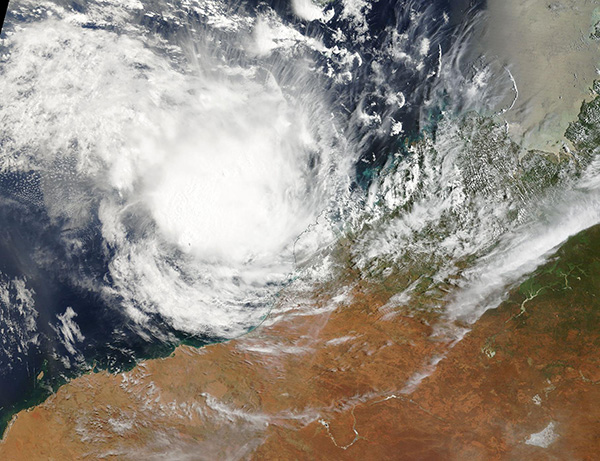
On February 22, 2024, the Moderate Resolution Imaging Spectroradiometer (MODIS) acquired a true-color image of Tropical Cyclone Lincoln re-forming off Australia’s Kimberly coast. At the time this image was captured, the storm was a tropical low, but was strengthening. Maximum sustained winds were reported at about 40 mph (64 km/h) through the afternoon and were expected to reach 45 mph (72.5 km/h) by early on February 23. That would place it as a Category 1 Tropical Cyclone on the Australian scale.
The Joint Typhoon Warning Center (JTWC) expects Tropical Cyclone Lincoln to continue to intensify through February 23 as it tracks roughly southward parallel to the Australian coast before turning southeastward. It is forecast to make landfall about 288 miles (463 km) south of Learmonth on February 24, most likely as a weak tropical cyclone or strong remnant low, then dissipate over land by the next day.
Tropical Cyclone Lincoln has traveled an unusual path since it was first formed over the Gulf of Carpentaria on February 15. It made landfall over northeastern Northern Territory on February 16 and by February 19 it had dissipated over land, according to the Global Disaster Alert and Coordination System (GDACS). Rainfall from this first passage of Lincoln resulted in flooding in eastern Kimberly, part of the Northern Territory, and central Queensland. At least one person died in a flash flood in Queensland.
The remnants of the storm passed over the Kimberly region and crossed the coast to reach the Indian Ocean on February 21. Favorable conditions encouraged the storm to stall in place and begin to consolidate before turning towards the coast to threaten a second landfall.
Image Facts
Satellite:
Terra
Date Acquired: 2/22/2024
Resolutions:
1km (404.1 KB), 500m (1.3 MB), 250m (3.7 MB)
Bands Used: 1,4,3
Image Credit:
MODIS Land Rapid Response Team, NASA GSFC
