
Images


March 8, 2024 - Crop Circles in the Saudi Desert

March 5, 2024
March 6, 2000
Tweet
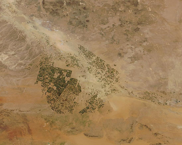
Neat patches of green filled part of the vast tan desert of Wadi As-Sirhan, Saudi Arabia on March 5, 2024, when the Moderate Resolution Imaging Spectroradiometer (MODIS) on NASA’s Terra satellite acquired this true-color image.
Located in the north of the country, Wadi As-Sirhan was little more than barren desert just a few decades ago, with rainfall and water so rare that only a few towns clung to survival. Images acquired as recently as 1986 show no green patches at all, just the tan tones typical of arid sand and gravel desert.
Since that time, patches of green began to sprout up—slowly at first and then more rapidly—thanks to the introduction of center-pivot irrigation. Sometimes called “precision agriculture,” this approach pumps water up from far underground and delivers it in rotation around a center point, creating a circular agricultural field.
Vegetables, fruit, and grains grow abundantly within the circles. Over time, the circular fields have also grown more abundant in the Wadi As-Sirhan and other parts of Saudi Arabia.
The water feeding the crop circles comes from an ancient aquifer and is thought to be about 20,000 years old. The al-Disi aquifer sits primarily under Saudi Arabia, but parts of it are located beneath Jordan. Like the oil that lies under the desert, the water within the aquifer is a non-renewable resource.
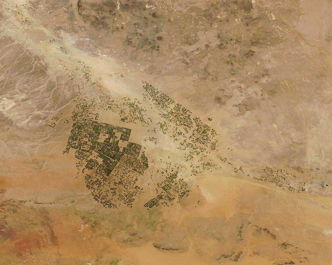
To illustrate the growth of agriculture in the Wadi As-Sirhan over time, today’s Image of the Day compares the image acquired by Terra MODIS on March 5, 2024, with one acquired of the same area by Terra MODIS on March 6, 2000. The expansion of center-pivot agriculture is obvious—and amazing. In these images, actively growing crops form circles of green while fallow fields appear brown.
Image Facts
Satellite:
Terra
Date Acquired: 3/5/2024
Resolutions:
1km (78.6 KB), 500m (198.5 KB), 250m (446.1 KB)
Bands Used: 1,4,3
Image Credit:
MODIS Land Rapid Response Team, NASA GSFC
March 5, 2024 March 6, 2000
Neat patches of green filled part of the vast tan desert of Wadi As-Sirhan, Saudi Arabia on March 5, 2024, when the Moderate Resolution Imaging Spectroradiometer (MODIS) on NASA’s Terra satellite acquired this true-color image.
Located in the north of the country, Wadi As-Sirhan was little more than barren desert just a few decades ago, with rainfall and water so rare that only a few towns clung to survival. Images acquired as recently as 1986 show no green patches at all, just the tan tones typical of arid sand and gravel desert.
Since that time, patches of green began to sprout up—slowly at first and then more rapidly—thanks to the introduction of center-pivot irrigation. Sometimes called “precision agriculture,” this approach pumps water up from far underground and delivers it in rotation around a center point, creating a circular agricultural field. Vegetables, fruit, and grains grow abundantly within the circles. Over time, the circular fields have also grown more abundant in the Wadi As-Sirhan and other parts of Saudi Arabia.
The water feeding the crop circles comes from an ancient aquifer and is thought to be about 20,000 years old. The al-Disi aquifer sits primarily under Saudi Arabia, but parts of it are located beneath Jordan. Like the oil that lies under the desert, the water within the aquifer is a non-renewable resource.
To illustrate the growth of agriculture in the Wadi As-Sirhan over time, today’s Image of the Day compares the image acquired by Terra MODIS on March 5, 2024, with one acquired of the same area by Terra MODIS on March 6, 2000. The expansion of center-pivot agriculture is obvious—and amazing. In these images, actively growing crops form circles of green while fallow fields appear brown.
Image Facts
Satellite:
Terra
Date Acquired: 3/5/2024
Resolutions:
1km (78.6 KB), 500m (198.5 KB), 250m (446.1 KB)
Bands Used: 1,4,3
Image Credit:
MODIS Land Rapid Response Team, NASA GSFC
