
Images


April 3, 2024 - Ship Tracks over the Pacific
 Tweet
Tweet
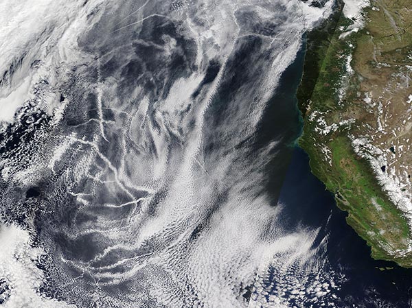
Linear clouds crisscrossed the Pacific Ocean off the coast of California in early April 2024, each marking the passage of a ship. The Moderate Resolution Imaging Spectroradiometer (MODIS) acquired this true-color image of the distinctive clouds known as “ship tracks” on April 1.
Ship tracks are thin, narrow clouds that form when water vapor condenses around the tiny particles emitted by ships in their exhaust. They don’t form over every passing ship, but tend to be found where thin, low-lying stratus and cumulus clouds are also present. Ship tracks often appear brighter than surrounding clouds, because clouds that form due to ship exhaust usually have more and smaller droplets than do normal, unpolluted clouds. The smaller droplets scatter light in many directions, and it is this increased reflectance that makes them appear white in satellite images.
This area of the North Pacific Ocean is a remarkably busy waterway, with heavy ship traffic year-round. The combination of a high number of ships releasing emissions and atmospheric conditions conducive to the formation of a variety of low-level clouds make the North Pacific a hot spot for viewing ship tracks.
Image Facts
Satellite:
Terra
Date Acquired: 4/1/2024
Resolutions:
1km (1 MB), 500m (3.2 MB),
Bands Used: 1,4,3
Image Credit:
MODIS Land Rapid Response Team, NASA GSFC
