
Images


May 18, 2024 - Springtime in the Strait of Tartary


May 16, 2024
May 4, 2024
Tweet
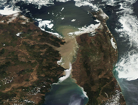
The Strait of Tartary sits in Russia’s Far East, separating the Russian mainland from Sakhalin Island. It is an important shipping route, as the narrow strait provides the shortest route between The Sea of Okhotsk (north) and the Sea of Japan (East Sea) in the south. At least it’s important for shipping about half the year. The other six months the Strait sits under a thick and impassable cap of ice.
Ice-up begins in November and is a relatively slow process, often taking six weeks or more to complete. In contrast, ice-out often is completed in two weeks, thanks to warming temperatures and rapidly lengthening sunlight. This was the case in 2024, when the Moderate Resolution Imaging Spectroradiometer (MODIS) on NASA’s Aqua satellite captured a set of true-color images of the Strait of Tartary.
The first true-color image was acquired by Aqua MODIS on March 16, 2024. At that time, the Strait was nearly completely ice-free with only a small amount remaining at the narrowest point between Russia’s mainland (west) and the Sakhalin Island Coast (east). The Strait’s waters were filled with mud-colored sediment, most of which had been swept into the Strait from the large Amur River.
Click on the date below the image to reveal a second true-color Aqua MODIS image acquired on May 4—only twelve days earlier. That scene is remarkably different, with the Strait of Tartary completely coated in ice. Sea ice also floated off the eastern coast of Sakhalin Island.
Image Facts
Satellite:
Aqua
Date Acquired: 5/16/2024
Resolutions:
1km (110.6 KB),
Bands Used: 1,4,3
Image Credit:
MODIS Land Rapid Response Team, NASA GSFC
May 16, 2024 May 4, 2024
The Strait of Tartary sits in Russia’s Far East, separating the Russian mainland from Sakhalin Island. It is an important shipping route, as the narrow strait provides the shortest route between The Sea of Okhotsk (north) and the Sea of Japan (East Sea) in the south. At least it’s important for shipping about half the year. The other six months the Strait sits under a thick and impassable cap of ice.
Ice-up begins in November and is a relatively slow process, often taking six weeks or more to complete. In contrast, ice-out often is completed in two weeks, thanks to warming temperatures and rapidly lengthening sunlight. This was the case in 2024, when the Moderate Resolution Imaging Spectroradiometer (MODIS) on NASA’s Aqua satellite captured a set of true-color images of the Strait of Tartary.
The first true-color image was acquired by Aqua MODIS on March 16, 2024. At that time, the Strait was nearly completely ice-free with only a small amount remaining at the narrowest point between Russia’s mainland (west) and the Sakhalin Island Coast (east). The Strait’s waters were filled with mud-colored sediment, most of which had been swept into the Strait from the large Amur River.
Click on the date below the image to reveal a second true-color Aqua MODIS image acquired on May 4—only twelve days earlier. That scene is remarkably different, with the Strait of Tartary completely coated in ice. Sea ice also floated off the eastern coast of Sakhalin Island.
Image Facts
Satellite:
Aqua
Date Acquired: 5/16/2024
Resolutions:
1km (110.6 KB),
Bands Used: 1,4,3
Image Credit:
MODIS Land Rapid Response Team, NASA GSFC
