
Images


May 19, 2024 - Burn Scars in Zambia

May 17, 2024
April 17, 2024
Tweet
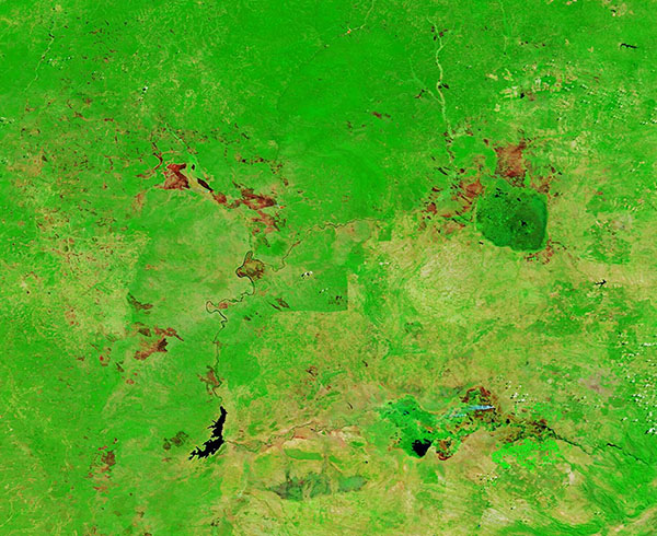
Widespread burn scars were visible marking the agricultural lands near the Kafue Flats, Zambia on May 17, 2024. This region of Zambia is filled with a vast, green, grassy savanna. The rich soil and the long rainy season combine to create an ecosystem that supports wildlife as well as rich soil and lush pastures suitable for agriculture.
Most of the farmers across central Africa, including Zambia, use fire to manage their agricultural plots. This includes clearing new land for crops, cleaning out dense savanna grasses spurred by the long rainy season, and renewing pastureland. Agricultural fires, especially those which are active when grasslands are drying after the end of the rainy season, which runs from November to April, can easily spark out-of-control wildfires. Traditionally, nearly 70 percent of the lands around Kafue National Park burn annually.
The changes in landcover created by annual fires in west-central Zambia is illustrated by two false-color images acquired by the Moderate Resolution Imaging Spectroradiometer (MODIS) on NASA’s Terra satellite, one acquired on May 17, 2024, and another acquired a month earlier, on April 17, 2024.
This type of false-color image uses infrared and visible light to help separate vegetation, which appears bright green, from water (deep inky blue) and burn scars. Such scars are left after fire scorches an area, and their color can vary from brick red to light brown or black depending on several factors including how much vegetation remains, how hot the burn was, how long ago the fire burnt the land, and even the color of the soil.
Burn scars stretch across the savanna on May 17, especially along the Kafue River which flows southward in the western part of the image and leads to the Itezhi-Tezhi Reservoir. Burn scars are also evident around Lake Manyeke and surrounding wetlands in the northeast.
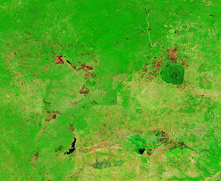
Click on the date to compare with the April 17 image, which was acquired very near the end of the rainy season. Except for a few very pale burn scars, the entire region is filled with lush green vegetation. The paleness of the burn scars suggest that they were not recent, but at least a year old. They are located in the same areas as the May 17 burn scars, suggesting that these areas are burned annually for agriculture.
Image Facts
Satellite:
Terra
Date Acquired: 5/17/2024
Resolutions:
1km (93.6 KB), 500m (244.8 KB), 250m (502 KB)
Bands Used: 7,2,1
Image Credit:
MODIS Land Rapid Response Team, NASA GSFC
May 17, 2024 April 17, 2024
Widespread burn scars were visible marking the agricultural lands near the Kafue Flats, Zambia on May 17, 2024. This region of Zambia is filled with a vast, green, grassy savanna. The rich soil and the long rainy season combine to create an ecosystem that supports wildlife as well as rich soil and lush pastures suitable for agriculture.
Most of the farmers across central Africa, including Zambia, use fire to manage their agricultural plots. This includes clearing new land for crops, cleaning out dense savanna grasses spurred by the long rainy season, and renewing pastureland. Agricultural fires, especially those which are active when grasslands are drying after the end of the rainy season, which runs from November to April, can easily spark out-of-control wildfires. Traditionally, nearly 70 percent of the lands around Kafue National Park burn annually.
The changes in landcover created by annual fires in west-central Zambia is illustrated by two false-color images acquired by the Moderate Resolution Imaging Spectroradiometer (MODIS) on NASA’s Terra satellite, one acquired on May 17, 2024, and another acquired a month earlier, on April 17, 2024.
This type of false-color image uses infrared and visible light to help separate vegetation, which appears bright green, from water (deep inky blue) and burn scars. Such scars are left after fire scorches an area, and their color can vary from brick red to light brown or black depending on several factors including how much vegetation remains, how hot the burn was, how long ago the fire burnt the land, and even the color of the soil.
Burn scars stretch across the savanna on May 17, especially along the Kafue River which flows southward in the western part of the image and leads to the Itezhi-Tezhi Reservoir. Burn scars are also evident around Lake Manyeke and surrounding wetlands in the northeast.
Click on the date to compare with the April 17 image, which was acquired very near the end of the rainy season. Except for a few very pale burn scars, the entire region is filled with lush green vegetation. The paleness of the burn scars suggest that they were not recent, but at least a year old. They are located in the same areas as the May 17 burn scars, suggesting that these areas are burned annually for agriculture.
Image Facts
Satellite:
Terra
Date Acquired: 5/17/2024
Resolutions:
1km (93.6 KB), 500m (244.8 KB), 250m (502 KB)
Bands Used: 7,2,1
Image Credit:
MODIS Land Rapid Response Team, NASA GSFC
