
Images


May 24, 2024 - Prescribed Burns near Flagstaff, Arizona
 Tweet
Tweet
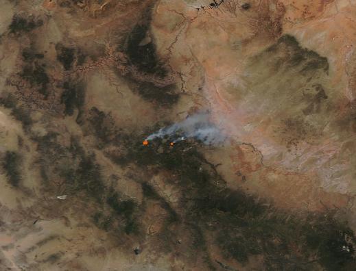
On May 22, 2024, the Moderate Resolution Imaging Spectroradiometer (MODIS) on NASA’s Aqua satellite acquired a true-color image of fresh fires burning in the grasslands west of Flagstaff, Arizona.
Each red “hot spot” marks an area where a fire is actively burning. Long plumes of smoke rise from the hot spots and blow towards the northeast. The drifting smoke has helped reduce air quality near the fires. The Air Quality Index (AQI) in Flagstaff dropped to 59 on May 23, which is considered “Poor”. According to Accuweather, this level means that “the air has reached a high level of pollution and is unhealthy for sensitive groups”.
The fires visible in this image are prescribed burns, based on information given on Inciweb Incident Information System and media reports. The larger fire in the west is in the Flagstaff Ranger District of the Coconino National Forest and is most likely in the Maxwell Springs Project area. The smaller hotspot is likely from Observatory Mesa within the outskirts of Flagstaff, where the city Fire Department conducted prescribed burns this week.
Prescribed burns are fires that are deliberately set and carefully managed on public lands. The goals include improving the health of the environment and to protect communities and structures near areas prone to wildfire. Such low-intensity fires remove smaller fuels in an area, which helps prevent accumulation of fuels that may feed intense wildfires later in the year.
Image Facts
Satellite:
Aqua
Date Acquired: 5/22/2024
Resolutions:
1km (28.6 KB), 500m (92.9 KB), 250m (262.5 KB)
Bands Used: 1,4,3
Image Credit:
MODIS Land Rapid Response Team, NASA GSFC
