Images
July 19, 2024 - Flooding in Bangladesh
Tweet
The 2024 monsoon season has battered Bangladesh, drowning parts of the country in extreme floods at least three times since May.
The first drenching occurred when Severe Cyclonic Storm Remal made landfall on the West Bengal coast on May 26 carrying maximum sustained winds of 60 miles per hour (96 kilometers per hour). It has been estimated that the storm was responsible for the death of 65 people in India and 19 in Bangladesh, mostly from flooding, and that power was knocked out for about 30 million people.
After the cyclone passed, heavy and repeated rains drenched the hill region of northern Bangladesh repeatedly starting in mid-June, again triggering widespread flooding. According to ReliefWeb, from June 16 harsh downpours in Bangladesh as well as the Indian states of Assam and Meghalaya led to the second spell of devastating floods. The districts of Sylhet and Sunamganj were inundated with up to 9.5 inches (242 mm) of rainfall in that storm. This exceeds the monthly average seasonal rainfall of the region. This flood alone affected 2.5 million people, leaving roads in the Sylhet region submerged.
Additional June storms brought severe flooding to the northern region of the country, encompassing the districts of Lalmonirhat, Kurigram, Gaibandha, Bogura, Sirajganj, Jamalpur, Tangail, and Munshiganj. The southeastern region also was inundated, including the districts of Feni, Rangamati, Khagrachari, Bandarban, and Coxs Bazar. Cox’s Bazar is the location of large refugee camps, where rising waters were reported to have forced residents to evacuate to cyclone shelters. According to ReliefWeb, in the southeast, critical infrastructures like schools, colleges, post offices, and other government offices were inundated, and local markets remained mostly non-functional as of July 7.
As the floodwaters began to recede in some districts, a third round of downpours submerged northern Bangladesh once again. These storms also inundated eastern Afghanistan and India and triggered flash floods and landslides in Nepal. CNN reports that 40 people have been killed and 347 injured in Afghanistan, 97 people died in floods in Assam state, India since May, and “dozens” have been killed in Nepal. Multiple deaths in Bangladesh have been reported from various sources, with over 2 million people currently impacted by flooding.
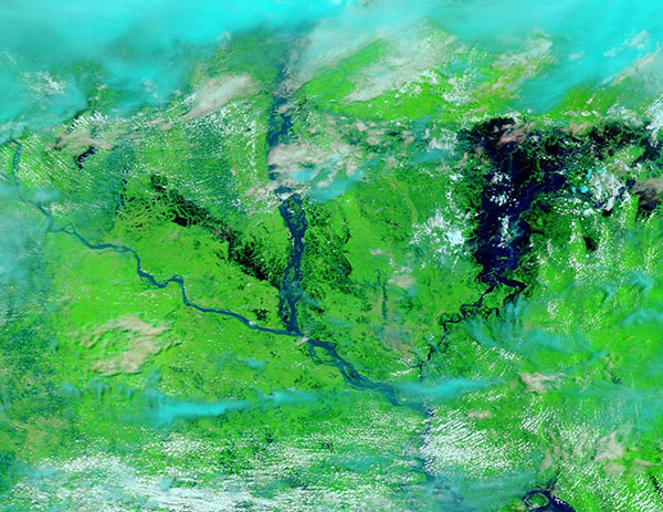
On July 18, 2024, the Moderate Resolution Imaging Spectroradiometer (MODIS) on NASA's Terra satellite acquired a false-color image of the most recent flood event in northern Bangladesh. This type of image helps separate water (blue) from vegetation (green). Clouds usually appear white, except for high, cold clouds that contain ice crystals, which are tinted electric blue. It is evident that all visible rivers are quite wide and the northeastern region, where the lower Brahmaputra flows into the Meghna, is completely under water. The Padma is the westernmost river. It flows into the very wide Jamuna then into the lower Meghna.
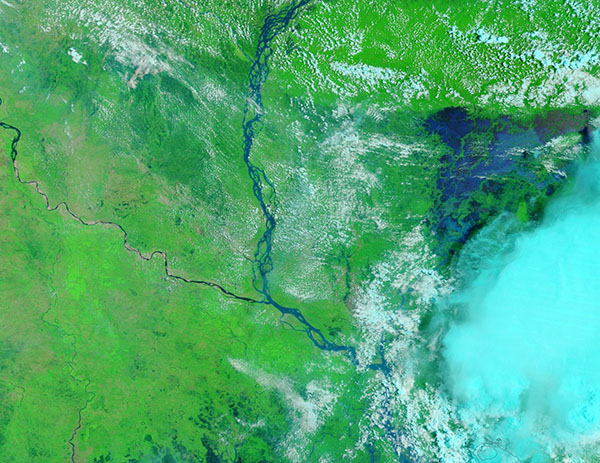
To see the impact of the latest storms, click on the dates to reveal a second Terra MODIS false-color image acquired on June 7, 2024. The scene is radically different. The Padma and Jamuna and lower Meghna are all at relatively normal levels, despite the recent passage of Severe Tropical Cyclone Remal. Some flooding can be seen in the east, at the edge of a storm cloud.
The monsoon season in Bangladesh normally starts in June and continues through mid-October.
Image Facts
Satellite:
Terra
Date Acquired: 7/18/2024
Resolutions:
1km (115.3 KB), 500m (303.3 KB), 250m (481.7 KB)
Bands Used: 7,2,1
Image Credit:
MODIS Land Rapid Response Team, NASA GSFC


