
Images


July 11, 2024 - Land Surface Temperture (Daytime) June 2024
 Tweet
Tweet
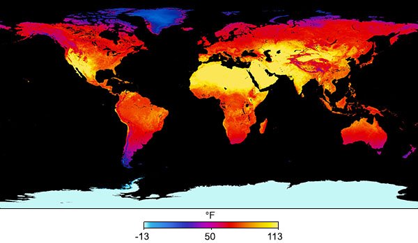
During the month of June 2024, the Moderate Resolution Imaging Spectroradiometer (MODIS) on NASA’s Terra satellite acquired data that was used to create this Land Surface Temperature (daytime) image of the Earth. The publication date for this image was June 30.
Land surface temperature is a measurement of how hot the top millimeter (about 0.04 inch) of the land is to the touch. It differs from air temperature (the temperature given in weather reports) because land heats and cools more quickly than air.
This image depicts land surface temperature in degrees Fahrenheit. The warmest temperatures are pale yellow, while the coldest temperatures are dark blue. Moderate temperatures are depicted in shades of pink and purple. Black means “no data” was gathered and is typical of ocean surfaces in this dataset.
June is summer in the Northern Hemisphere and winter in the Southern Hemisphere The most frigid temperatures, not surprisingly, are found in Antarctica, where it is deep winter. This is evident by the white area at the bottom of the image. The Arctic, found in the far north (top) is also showing cool land temperature.
A large swath of the center of the Earth’s land masses, however, are covered in yellows, depicting temperatures in the 90-113°F range. This includes the Western United States, portions of northern South America, the Sahara Desert and part of the Sahel in Africa as well as the Horn of Africa, the Arabian Peninsula, India, parts of China, Mongolia, and Russia, and even the top end of Australia. Western Madagascar is also showing high land surface temperatures despite its location far south of the equator.
Of particular note is that the boreal forest and northern tundra regions of North American, Russia, and Europe appear in red, suggesting substantially warm land surface temperatures. In some boreal regions, where the ground is typically in permafrost and stays frozen year-round, land surface temperature appears to approach 80°F—quite warm for boreal forests in June. One example which has been used to illustrate summer temperatures in boreal forests is Lahti, Finland. The mean average temperature in June between 1970 and 2000 in Lahti was 59°F, according to an article published by NASA’s Earth Observatory Earth Explorer site. The article can be found here.
Also, click on this link to view a large resolution version of this image.
Image Facts
Satellite:
Terra
Date Acquired: June 2024
Resolutions:
Bands Used: 20,22,23,39,31,32
Image Credit:
MODIS Land Rapid Response Team, NASA GSFC
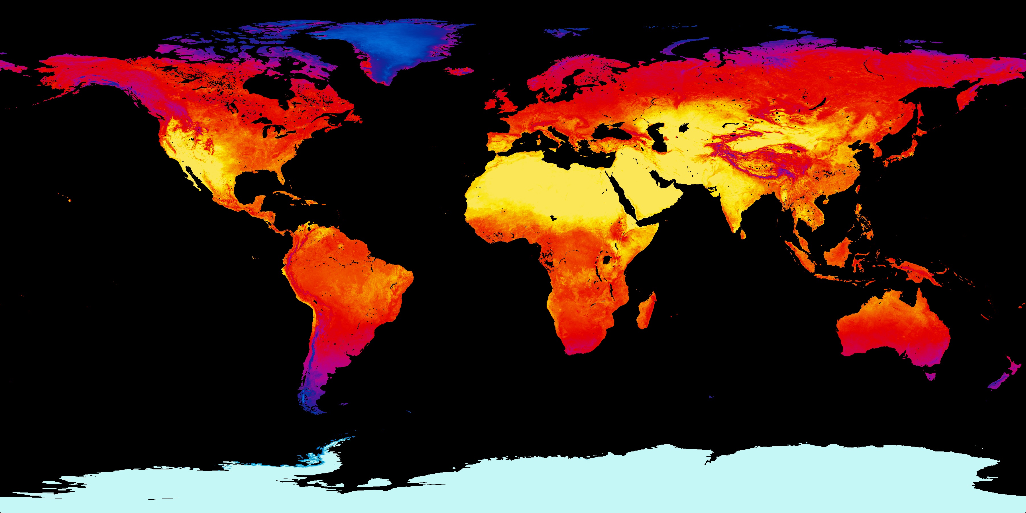
