
Images


July 16, 2024 - Hamoun Wetlands and the Godzareh Depression
 Tweet
Tweet
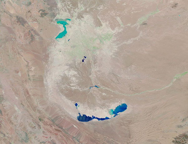
The Sistan Basin is a depression that stretches across the border between southeastern Iran and southwestern Afghanistan. A large, complex wetlands made up of shallow lakes and complex marshlands, known as the Hamoun Wetlands covers about 800 square miles (2,000 square kilometers) of the basin, primarily in the northern region. The lowest point in the basin, however, sits in Afghanistan at the southernmost reach. Known as the Godzareh Depression, it is filled with saline waters. The Hamoun Wetlands, in contrast, are freshwater marshes and shallow lakes.
Once a large and thriving oasis that provided food and livelihoods for residents of Central Asia, the wetlands began to rapidly dry up as water was diverted from the Helmand River (the principal river feeding the Sistan Basin), as temperatures warmed, and as drought gripped the region. Today, although efforts are being made to restore and protect the vital wetlands, the arid soils of the region are often a source for massive dust storms.
The Moderate Resolution Imaging Spectroradiometer (MODIS) on NASA’s Terra satellite acquired a false-color image of the Hamoun Wetlands (north) and the Godzareh depression (south) on June 22, 2024.
This type of false-color image helps separate vegetation, which looks bright green, from water, which looks blue. In general, the deeper the water the darker it appears. In addition, open land shows up in shades of tan.
A shallow lake can be seen in the Hamoun Wetlands in the northwestern section of the Sistan Basin. However, most of the moisture in the wetlands is evidenced only by a widespread flush of green across the northern portion of the basin, but no water is visible. The Godzareh depression, in the south, is filled with deeper water. The Helmand River holds only very little visible water, but a trace of moisture along its course is evident by the presence of vegetation along the riverbanks.
Image Facts
Satellite:
Terra
Date Acquired: 6/22/2024
Resolutions:
1km (41.5 KB), 500m (100.8 KB), 250m (159.4 KB)
Bands Used: 7,2,1
Image Credit:
MODIS Land Rapid Response Team, NASA GSFC
