
Images


July 29, 2024 - Northwestern Passage
 Tweet
Tweet
The Northwest Passage traces a sea route from Europe to Asia that winds through islands along the northern edge of Canada—a route much shorter than a trip around the southern tip of Africa. While such a passage was a longed-for dream as far back as the second century A.D., it wasn’t until 1906 that the first recorded successful voyage through the Northwest Passage was completed. It took Roald Amundsen and his crew of six three years to sail his 70x20 foot sloop, a converted herring boat named Gjøa, through the icy passage.
As the climate warms, the passage across the top of Canada becomes more of a reality. Summer Arctic sea ice minimum extent reached a new low in 2007, creating conditions that fostered more frequent success for mariners attempting the crossing. The summer Arctic sea ice minimum reached a new record low in 2012. And, according to the NASA Climate website, summer Arctic sea ice extent is shrinking by 12.2% per decade due to warmer temperatures. Traffic through the Northwest Passage now occurs on a regular basis during the peak of summer.
There is a twist to the story, however.
According to YaleClimate 360, melting sea ice appears to be making the Northwest Passage more difficult. As ice melts nearer the North Pole, it releases chunks of ice large enough to prove dangerous to ships. And these chunks are floating down to the waters around northern Canada. They cite an article published in the journal Communications Earth and Environment, which found that the navigable period in the Eastern Beaufort Sea, at the eastern edge of the passage, shrunk from 27 weeks in 2007 to 13 weeks in 2021.
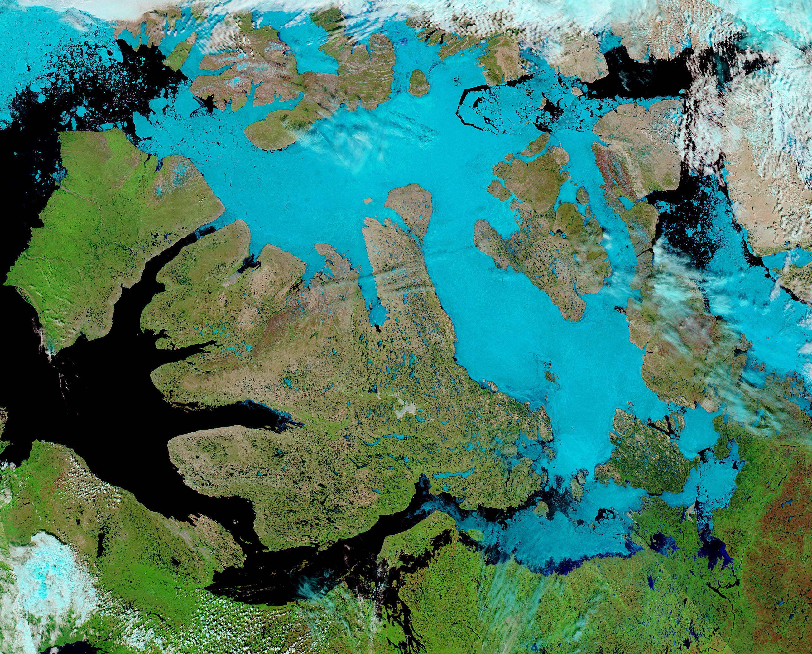
On July 13, 2024, the Northwest Passage appeared to remain firmly covered in ice, based on this false-color image captured by the Moderate Resolution Imaging Spectroradiometer (MODIS) on NASA’s Aqua satellite. The image centers on Victoria Island, the largest island visible. The route across the passage requires skirting Victoria Island either to the south or north.
This type of image uses a combination short-wave infrared, near infrared, and visible light (MODIS bands 7-2-1) to help highlight snow and ice, both of which appear bright electric blue. In contrast, open, ice-free, ocean water looks deep blue. Vegetation is green, open land is tan, and clouds are usually white although high, cold clouds which are filled with ice crystals may take on a tint of pale electric blue.
Image Facts
Satellite:
Aqua
Date Acquired: 7/13/2024
Resolutions:
1km (602.1 KB), 500m (1.8 MB), 250m (4.6 MB)
Bands Used: 7,2,1
Image Credit:
MODIS Land Rapid Response Team, NASA GSFC
The Northwest Passage traces a sea route from Europe to Asia that winds through islands along the northern edge of Canada—a route much shorter than a trip around the southern tip of Africa. While such a passage was a longed-for dream as far back as the second century A.D., it wasn’t until 1906 that the first recorded successful voyage through the Northwest Passage was completed. It took Roald Amundsen and his crew of six three years to sail his 70x20 foot sloop, a converted herring boat named Gjøa, through the icy passage.
As the climate warms, the passage across the top of Canada becomes more of a reality. Summer Arctic sea ice minimum extent reached a new low in 2007, creating conditions that fostered more frequent success for mariners attempting the crossing. The summer Arctic sea ice minimum reached a new record low in 2012. And, according to the NASA Climate website, summer Arctic sea ice extent is shrinking by 12.2% per decade due to warmer temperatures. Traffic through the Northwest Passage now occurs on a regular basis during the peak of summer.
There is a twist to the story, however.
According to YaleClimate 360, melting sea ice appears to be making the Northwest Passage more difficult. As ice melts nearer the North Pole, it releases chunks of ice large enough to prove dangerous to ships. And these chunks are floating down to the waters around northern Canada. They cite an article published in the journal Communications Earth and Environment, which found that the navigable period in the Eastern Beaufort Sea, at the eastern edge of the passage, shrunk from 27 weeks in 2007 to 13 weeks in 2021.
On July 13, 2024, the Northwest Passage appeared to remain firmly covered in ice, based on this false-color image captured by the Moderate Resolution Imaging Spectroradiometer (MODIS) on NASA’s Aqua satellite. The image centers on Victoria Island, the largest island visible. The route across the passage requires skirting Victoria Island either to the south or north.
This type of image uses a combination short-wave infrared, near infrared, and visible light (MODIS bands 7-2-1) to help highlight snow and ice, both of which appear bright electric blue. In contrast, open, ice-free, ocean water looks deep blue. Vegetation is green, open land is tan, and clouds are usually white although high, cold clouds which are filled with ice crystals may take on a tint of pale electric blue.
Image Facts
Satellite:
Aqua
Date Acquired: 7/13/2024
Resolutions:
1km (602.1 KB), 500m (1.8 MB), 250m (4.6 MB)
Bands Used: 7,2,1
Image Credit:
MODIS Land Rapid Response Team, NASA GSFC
