
Images


February 9, 2025 - Ice and Sediment in the Cook Inlet
 Tweet
Tweet
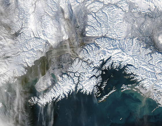
Ice and sediment colored Alaska’s Cook Inlet on February 2, 2025, when the Moderate Resolution Imaging Spectroradiometer (MODIS) on NASA’s Aqua satellite acquired this true-color image.
The Cook Inlet is an important lifeline to Southcentral Alaska, connecting Anchorage, the state’s largest city, to the North Pacific Ocean. It stretches northeast for 220 miles (350 kilometers) between mainland Alaska and the Kenai Peninsula. Salty ocean water flows into the inlet from its southern end while the northern end receives freshwater from several large rivers that drain Southcentral Alaska.
Tidal action from the ocean is strong and constantly stirs up sediment from the bottom. Additionally, the mighty rivers coursing across the basin collect sediment, especially glacial flour (finely ground rock created by the action of glaciers), ultimately dumping it into the inlet. And the upper Inlet is characterized by copious broad mud flats. All of these factors make Cook Inlet famous for its dark, silt-laden color.
When this image was captured, strong north winds were blowing across the region and were laden with gray dust, most likely rich in glacial flour. Snow cover has been low in much of Southcentral Alaska in 2025, leaving soils bare and making conditions ripe for dusty skies.
Image Facts
Satellite:
Aqua
Date Acquired: 2/2/2025
Resolutions:
1km (182.5 KB), 500m (559.2 KB), 250m (1.3 MB)
Bands Used: 1,4,3
Image Credit:
MODIS Land Rapid Response Team, NASA GSFC
