
Images


March 22, 2025 - Clouds over the Mediterranean
 Tweet
Tweet
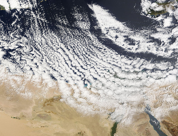
Chilly weather and strong wind helped create striking cloud formations over the Mediterranean Sea in late March 2025. The Moderate Resolution Imaging Spectroradiometer (MODIS) on NASA’s Terra satellite acquired this true-color image of the cloudy scene on March 20.
The long rows of cumulus clouds running parallel to each other are called “cloud streets”. most prominent cloud formation seen in this image is known as “cloud streets” or, more technically, as “horizontal convective rolls”. They form when cold air blows over warmer water and a warmer air layer (temperature inversion) rests over the top of both. The water gives up heat and moisture to the cold air above, and columns of heated air naturally rise through the atmosphere. The temperature inversion acts like a lid, so when the rising thermals hit it, they roll over and loop back on themselves, creating parallel cylinders of rotating air. As this happens, the moisture cools and condenses into cumulus clouds that line up parallel to the direction of the prevailing winds.
Air temperatures were warm in mid-March across the region, registering as high as 86°F (30°C) Port Said, Egypt on March 16, according to Weather Underground. Temperatures tumbled on March 20, however, with highs of only 64°F (17.8°C) in Port Said, with winds blowing from the northwest. Since sea surface temperatures change more slowly than air temperature, even though the air wasn’t frigid, the difference between the air temperature and water temperature was sufficient to allow the creation of this beautiful formation.
Image Facts
Satellite:
Terra
Date Acquired: 3/20/2025
Resolutions:
1km ( B), 500m ( B), 250m (2.2 MB)
Bands Used: 1,4,3
Image Credit:
