
Images


September 18, 2025 - Burn Scars in British Columbia

September 17, 2025
June 9, 2025
Tweet
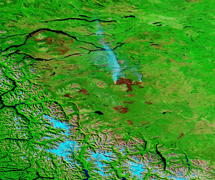
Canada’s wildland fire season has been a tough one, with 5,371 fires burning 8.8 million hectares across the country from January 1 through mid-September 2025. Western Canada, especially British Columbia was hit particularly hard. The Canadian Interagency Forest Fire Centre (CIFFC) reported that, on September 16, 125 fires were active in British Columbia—the highest of any province.
The Moderate Resolution Imaging Spectroradiometer (MODIS) on NASA’s Aqua satellite acquired a pair of false-color images that help visualize the ravages of fire in the Cariboo Region of British Columbia. The top image was acquired on September 17, 2025, and the second was captured on June 9, 2025. The images can be compared simply by clicking on the dates.
In this type of image, vegetation looks green, water is blue, snow and smoke both show up as light electric blue and open land appears tan. Burn scars—the area left behind after land has been seared by fire—can show up in a variety of tones that vary from greenish (old scars where vegetation is returning), to a range of browns and tans. The color depends on many factors, including age of the fire, type of soil, and how completely vegetation was burnt. Very fresh scars usually appear dark brick red, while actively burning fire shows up as an orange blob.
The Itcha Lake Fire dominates the September 17 image, with a very large brick-red burn scar, three active fire fronts, and heavy smoke. According to the BC Wildfire Service, the fire had burnt 54,634 hectares and was classified as “out of control” on that date. It was first reported on August 27 and was ignited by lightning. Also note the burn scars in the northwest (upper left). They retain brick-red color, but green vegetation appears to be growing in some areas, suggesting the scars may be from early this year.
The June 9 image shows a markedly different landscape, with much fewer new burn scars visible. The Itcha Lake Fire has not yet ignited, nor has any of the other nearby fires, although the green grasslands are marked with the faint burn scars that mark older fires. The scars in the northwest, however, appear more distinct, with less vegetation than on September 17.
Image Facts
Satellite:
Aqua
Date Acquired: 9/17/2025
Resolutions:
1km (378.2 KB), 500m (971.9 KB), 250m (2.2 MB)
Bands Used: 7,2,1
Image Credit:
MODIS Land Rapid Response Team, NASA GSFC
September 17, 2025 June 9, 2025
Canada’s wildland fire season has been a tough one, with 5,371 fires burning 8.8 million hectares across the country from January 1 through mid-September 2025. Western Canada, especially British Columbia was hit particularly hard. The Canadian Interagency Forest Fire Centre (CIFFC) reported that, on September 16, 125 fires were active in British Columbia—the highest of any province.
The Moderate Resolution Imaging Spectroradiometer (MODIS) on NASA’s Aqua satellite acquired a pair of false-color images that help visualize the ravages of fire in the Cariboo Region of British Columbia. The top image was acquired on September 17, 2025, and the second was captured on June 9, 2025. The images can be compared simply by clicking on the dates.
In this type of image, vegetation looks green, water is blue, snow and smoke both show up as light electric blue and open land appears tan. Burn scars—the area left behind after land has been seared by fire—can show up in a variety of tones that vary from greenish (old scars where vegetation is returning), to a range of browns and tans. The color depends on many factors, including age of the fire, type of soil, and how completely vegetation was burnt. Very fresh scars usually appear dark brick red, while actively burning fire shows up as an orange blob.
The Itcha Lake Fire dominates the September 17 image, with a very large brick-red burn scar, three active fire fronts, and heavy smoke. According to the BC Wildfire Service, the fire had burnt 54,634 hectares and was classified as “out of control” on that date. It was first reported on August 27 and was ignited by lightning. Also note the burn scars in the northwest (upper left). They retain brick-red color, but green vegetation appears to be growing in some areas, suggesting the scars may be from early this year.
The June 9 image shows a markedly different landscape, with much fewer new burn scars visible. The Itcha Lake Fire has not yet ignited, nor has any of the other nearby fires, although the green grasslands are marked with the faint burn scars that mark older fires. The scars in the northwest, however, appear more distinct, with less vegetation than on September 17.
Image Facts
Satellite:
Aqua
Date Acquired: 9/17/2025
Resolutions:
1km (378.2 KB), 500m (971.9 KB), 250m (2.2 MB)
Bands Used: 7,2,1
Image Credit:
MODIS Land Rapid Response Team, NASA GSFC
