
Images


June 27, 2018 - Clouds over Cape Verde Islands
 Tweet
Tweet
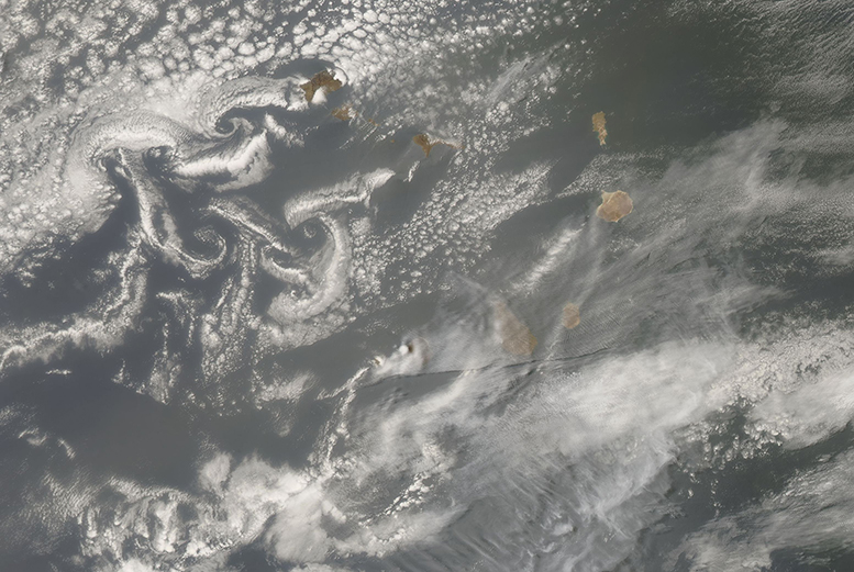
The movement of the wind was written in cursive-style clouds around Cape Verde Islands in late June 2018.
The Republic of Cape Verde is made up of ten volcanic islands clustered off the western coast of Senegal and Mauritania. The islands span slightly more than 1,540 square miles (4,000 square kilometers) in area. Created by volcanic activity, the topography of the islands is rugged and steep, reaching 9,281 feet (2,829 meters).
Strong winds blow off the African coast on a regular basis, often carrying a huge load of dust from the Sahara Desert. When dust becomes entrained in upper-level winds, it can be carried unimpeded across the Atlantic Ocean to fertilize locations such as the Amazon in South American - even reach North America. Lower-level winds also roar off the coast of Africa with little obstruction – until it slams into the tall peaks of the Cape Verde Islands. The immobile topography stops the forward flow of wind, pushing it around the volcanic mountains and creating turbulence on the lee side of the islands. If skies are clear, this turbulence is typically invisible from space but when clouds are present, the clouds swirl along with the wind, creating patterns that paint a stunning picture when viewed from a satellite.
On June 24, 2018, the Moderate Resolution Imaging Spectroradiometer (MODIS) aboard NASA’s Aqua satellite acquired a true-color image of swirling patterns in the clouds on the leeward side of the Cape Verde Islands. The relatively disorganized patterns suggest that the winds were changeable rather than blowing steadily from one direction. The sky is also filled with grayish-tan Saharan dust which is so thick that it obscures much of the ocean and some of the landscape of the islands.
Image Facts
Satellite:
Date Acquired: 6/24/2018
Resolutions:
1km (322.2 KB), 500m (889.8 KB), 250m (758.4 KB)
Bands Used: 1,4,3
Image Credit:
Jeff Schmaltz, MODIS Land Rapid Response Team, NASA GSFC
