
Images


May 20, 2024 - Great Salt Lake at Highest Level in Years


May 16, 2024
May 15, 2022
Tweet
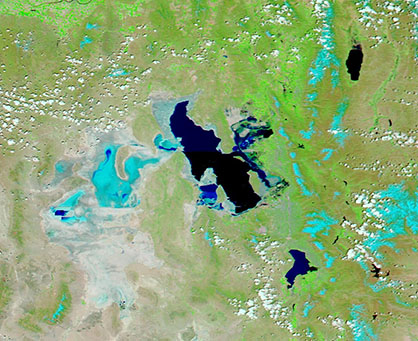
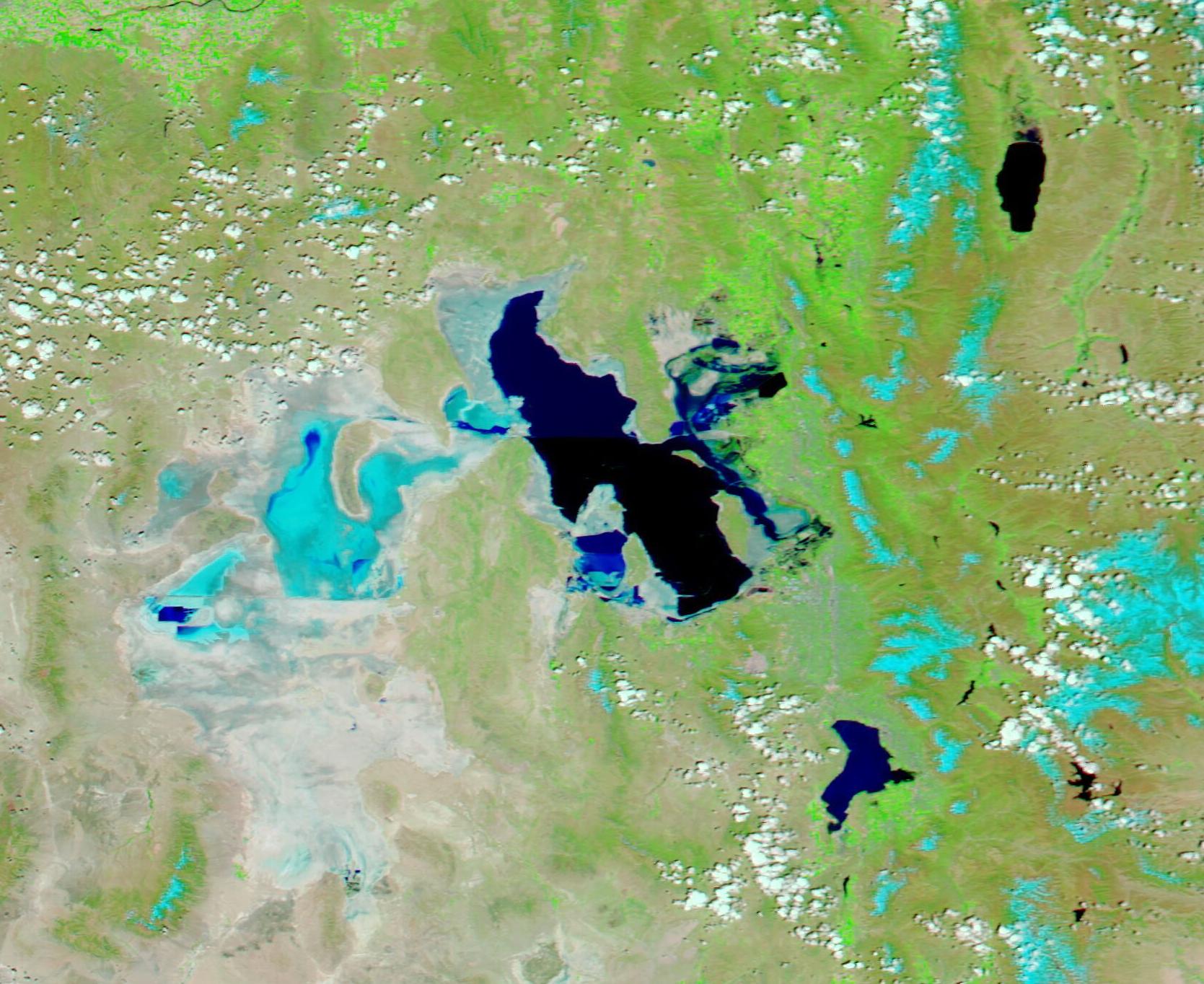
In November 2022, the Great Salt Lake, Utah’s most famous landmark, reached a new record low water level when the average daily value reached 4,188.5 feet above sea level, as measured at the South Arm Causeway gauge. On May 8, 2024, roughly a year and half later, the water level reached 4,195.1 feet—the highest level since 2017.
The welcome rise in water levels comes after two precipitation-filled winters which eased drought in the area and left a deliciously thick snowpack atop the surrounding mountains. According to the Utah Department of Natural Resources, the snowpack peaked at 18.8 inches on April 2, surpassing the median peak snowpack of 16 inches. As of May 19, substantial water remains in the mountain snow and it will trickle into local reservoirs and the Great Salt Lake over the next several weeks, potentially raising water levels still higher.
Despite the welcome increase in water, the Office of the Great Salt Lake Commissioner estimates that the “healthy” water level for the lake should be between 4,196 and 4,200 feet. At that level, not only are salt levels in the lake more suitable for supporting several species of living organisms, but more the lakebed would be submerged. The dry lakebed is a source of dust that carries manufactured toxins, such as arsenic, cadmium, lead, copper, and mercury, as well as natural cyanotoxins from historic algae blooms, according to Utah State University Institute for Land, Water, and Air.
The Moderate Resolution Imaging Spectroradiometer (MODIS) on NASA’s Aqua satellite acquired a pair of false-color images of the Great Salt Lake, one acquired on May 16, 2024, and the second acquired on May 15, 2022, which illustrate the recent increase in water levels.
This type of false-color image highlights water (dark blue) and helps separate it from vegetation (bright green). Open land looks tan while highly reflective substances, such as snow and salt, appear electric blue.
The salt crusts, which overlie part of the historic lakebed, form swirling flats to the west of the lake. They also appear close to the lake shore. Snow is located to the east of the Great Salt Lake.
Toggling between the two images by clicking on the dates reveals the noticeable change in water level between May 2022, when the lake was approaching historic lows, and May 2024 when the Great Salt Lake’s water level has approached healthy for the first time in decades.
Image Facts
Satellite:
Aqua
Date Acquired: 5/16/2024
Resolutions:
1km (90 KB), 500m (209.4 KB), 250m (302.9 KB)
Bands Used: 7,2,1
Image Credit:
MODIS Land Rapid Response Team, NASA GSFC
May 16, 2024 May 15, 2022
In November 2022, the Great Salt Lake, Utah’s most famous landmark, reached a new record low water level when the average daily value reached 4,188.5 feet above sea level, as measured at the South Arm Causeway gauge. On May 8, 2024, roughly a year and half later, the water level reached 4,195.1 feet—the highest level since 2017.
The welcome rise in water levels comes after two precipitation-filled winters which eased drought in the area and left a deliciously thick snowpack atop the surrounding mountains. According to the Utah Department of Natural Resources, the snowpack peaked at 18.8 inches on April 2, surpassing the median peak snowpack of 16 inches. As of May 19, substantial water remains in the mountain snow and it will trickle into local reservoirs and the Great Salt Lake over the next several weeks, potentially raising water levels still higher.
Despite the welcome increase in water, the Office of the Great Salt Lake Commissioner estimates that the “healthy” water level for the lake should be between 4,196 and 4,200 feet. At that level, not only are salt levels in the lake more suitable for supporting several species of living organisms, but more the lakebed would be submerged. The dry lakebed is a source of dust that carries manufactured toxins, such as arsenic, cadmium, lead, copper, and mercury, as well as natural cyanotoxins from historic algae blooms, according to Utah State University Institute for Land, Water, and Air.
The Moderate Resolution Imaging Spectroradiometer (MODIS) on NASA’s Aqua satellite acquired a pair of false-color images of the Great Salt Lake, one acquired on May 16, 2024, and the second acquired on May 15, 2022, which illustrate the recent increase in water levels. This type of false-color image highlights water (dark blue) and helps separate it from vegetation (bright green). Open land looks tan while highly reflective substances, such as snow and salt, appear electric blue.
The salt crusts, which overlie part of the historic lakebed, form swirling flats to the west of the lake. They also appear close to the lake shore. Snow is located to the east of the Great Salt Lake.
Toggling between the two images by clicking on the dates reveals the noticeable change in water level between May 2022, when the lake was approaching historic lows, and May 2024 when the Great Salt Lake’s water level has approached healthy for the first time in decades.
Image Facts
Satellite:
Aqua
Date Acquired: 5/16/2024
Resolutions:
1km (90 KB), 500m (209.4 KB), 250m (302.9 KB)
Bands Used: 7,2,1
Image Credit:
MODIS Land Rapid Response Team, NASA GSFC
