
Images


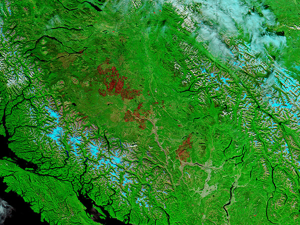
October 1, 2017 - Burn scars in British Columbia (false color)
 Tweet
Tweet
This summer Canada was plagued with huge forest fires that have spanned most of the provinces. British Columbia has been particularly hard hit with large portions of the landscape being decimated by fire.
On September 27, 2017, the Moderate Resolution Imaging Spectroradiometer (MODIS) aboard NASA’s Aqua satellite acquired a false-color image of expansive burn scars in British Columbia.
MODIS imagery, especially the 7,2,1 (false color) band combination, is an excellent tool for assessing the presence and impact of fires. Recent fires scars appear a dark brown or reddish-brown, because vegetation has burned away leaving open land visible. Vegetation appears a bright green, contrasting nicely with the fire scar. Fire scars fade as vegetation begins to regrown in the burned area. Early regrowth looks slightly paler than new burn and several years of regrowth appears only slightly darkened. In this image, not only is a large, fresh burn scar visible from the ravages of this year’s fire season, but there is also evidence of several previous burn scars which are filling in with vegetation.
While there is no evidence of active fire in this burn scar, the fire season is not over. As of September 29, the British Columbia Wildfire Service reports 745 wildfires larger than 0.01 hectare actively burning in the province.
Image Facts
Satellite:
Aqua
Date Acquired: 9/27/2017
Resolutions:
1km (342.2 KB), 500m (1.1 MB), 250m (2.7 MB)
Bands Used: 7,2,1
Image Credit:
Jeff Schmaltz, MODIS Land Rapid Response Team, NASA GSFC
This summer Canada was plagued with huge forest fires that have spanned most of the provinces. British Columbia has been particularly hard hit with large portions of the landscape being decimated by fire. On September 27, 2017, the Moderate Resolution Imaging Spectroradiometer (MODIS) aboard NASA’s Aqua satellite acquired a false-color image of expansive burn scars in British Columbia.
MODIS imagery, especially the 7,2,1 (false color) band combination, is an excellent tool for assessing the presence and impact of fires. Recent fires scars appear a dark brown or reddish-brown, because vegetation has burned away leaving open land visible. Vegetation appears a bright green, contrasting nicely with the fire scar. Fire scars fade as vegetation begins to regrown in the burned area. Early regrowth looks slightly paler than new burn and several years of regrowth appears only slightly darkened. In this image, not only is a large, fresh burn scar visible from the ravages of this year’s fire season, but there is also evidence of several previous burn scars which are filling in with vegetation.
While there is no evidence of active fire in this burn scar, the fire season is not over. As of September 29, the British Columbia Wildfire Service reports 745 wildfires larger than 0.01 hectare actively burning in the province.
Image Facts
Satellite:
Aqua
Date Acquired: 9/27/2017
Resolutions:
1km (342.2 KB), 500m (1.1 MB), 250m (2.7 MB)
Bands Used: 7,2,1
Image Credit:
Jeff Schmaltz, MODIS Land Rapid Response Team, NASA GSFC
