
Images


March 7, 2019 - Ronne Ice Shelf, Antarctica
 Tweet
Tweet
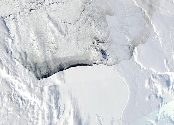
On March 2, 2019, the Moderate Resolution Imaging Spectroradiometer (MODIS) on board NASA’s Aqua satellite acquired a stunning true-color image of the Ronne Ice Shelf.
The Ronne Ice Shelf, named after Edit Ronne, the first American woman to visit Antarctica, sits on the Weddell Sea, just to the east of the Antarctic Peninsula and on the back slope of the Transantarctic Mountains. This massive ice shelf—the second largest in Antarctica—encompasses an area of about 170660 square miles (422,000 square km). The deep blue water of the Weddell Sea can be seen at the edge of the ice sheet while floating ice covers the rest of the water visible.
The sea ice surrounding the great Antarctic ice shelves plays an important role in the health of the ice sheet. Studies have shown that during the autumn and winter months that the amount of salt released in the formation of sea ice turns the water near and below the Ronne Ice Shelf into something like a protective sheath of extremely saline water. With an average temperature of about minus 2 degrees Celsius, this salty water helps shield the ice shelf from the warmer waters carried by the Weddell Gyre.
A study published in the Journal of Climate in 2017 expresses concern about the fate of the southern Weddell Sea continental ice shelf in a time of warming climate. Rising air temperatures over the Weddell Sea could cause less sea ice to form, and warmer water masses to move closer to, and under, the ice shelf. This breakdown of the protective cold, saline layer around the ice shelf as well as the influx of warmer water is expected to ultimately significantly affect the Ronne Ice Shelf, as well as the Filchner Ice Shelf, which sits very close to the Ronne, potentially causing significant melting over future decades.
Image Facts
Satellite:
Aqua
Date Acquired: 3/2/2019
Resolutions:
1km (137.8 KB), 500m (366.7 KB), 250m (1.4 MB)
Bands Used: 1,4,3
Image Credit:
MODIS Land Rapid Response Team, NASA GSFC
