Images
July 14, 2019 - Ice in Hudson Bay
Tweet
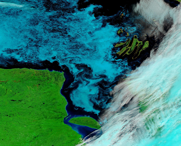
The summer ice melt on Hudson Bay was well under way in early July 2019, leaving a thin layer of ice floating on the southeastern waters.
The Moderate Resolution Imaging Spectroradiometer (MODIS) on board NASA’s Terra satellite acquired this beautiful false-color image of a swatch of southeastern Hudson Bay on July 11 2019. The false-color bands, in this case 7-2-1, help visualize ice and to separate ice from cloud. Both ice and cloud are white in true-color image, but in this band combination ice appears bright electric blue and cloud appears white, or (if the clouds are cold and contain ice), white with a light tint of pale electric blue. Vegetation appears bright green while shallow water appears dark blue and deep water appears black.
Shallow and surrounded by land, Hudson Bay freezes over completely in the winter but thaws for periods in the summer. Usually all of the sea ice is gone by August, and the bay begins to freeze over in October or November. In between, as the sea ice is breaking up, winds and currents cause flotillas of pack ice to cluster in certain parts of the bay as currents carry thin ice, sometimes creating swirls and designs.
One of the most noticeable features in the image is the Belcher Islands, a curved set of islands in the southeastern part of the bay that is rich with hunting and fishing grounds for the Inuit communities who live on them. We can also see the D-shaped Akimiski Island, which is to the south in James Bay. The island has no permanent human residents, but it is the site of a sanctuary for hundreds of thousands of migratory birds each year.
The rhythms of sea ice play a central role in the lives of the animals of Hudson Bay, particularly polar bears. When the bay is topped with ice, polar bears head out to hunt for seals and other prey. When the ice melts in the summer, the bears swim to shore, where they fast until sea ice returns. Reports of polar bear coming onshore have started in early July this year. A video captured a polar bear on land on July 5, and Andrew Derocher, a scientist studying polar bears, reported that on July 6, one or two of the bears carrying collars or ear tags from his study had come ashore near Churchill, a coastal town to the west of this image.
Image Facts
Satellite:
Terra
Date Acquired: 7/11/2019
Resolutions:
1km (722.8 KB), 500m (1.9 MB), 250m (4.8 MB)
Bands Used: 7,2,1
Image Credit:
MODIS Land Rapid Response Team, NASA GSFC


